| Home >> | Advanced Search >> |
 |
|
Astronaut Photography of Earth - Display Record
ISS001-323-21

Low-resolution Browse Image
(Most browse images are not color adjusted.)Images
Conditions for Use of Images >>Image Transformation Tutorial >> Saving, Color Adjusting, and Printing Images >>
Images to View on Your Computer Now
| File Name | File Size (bytes) | Width | Height | Annotated | Cropped | Purpose | Comments | |
|---|---|---|---|---|---|---|---|---|
| View | ISS001-323-21.JPG | 38454 | 515 | 345 | No | No | From ISD highres, sharpened | |
| View | ISS001-323-21.JPG | 100344 | 540 | 805 | Yes | No | NASA's Earth Observatory web site | |
| View | ISS001-323-21.JPG | 728081 | 1992 | 2968 | No | No | NASA's Earth Observatory web site | |
| View | ISS001-323-21_2.JPG | 209677 | 400 | 596 | No | No | Photographic Highlights |
Large Images to Request for Downloading
| File Name | File Size (bytes) | Width | Height | Annotated | Cropped | Purpose | Comments | |
|---|---|---|---|---|---|---|---|---|
| Request | ISS001-323-21_2.JPG | 306862 | 3070 | 2044 | No | No | From ISD CD TIFF images | |
| Request | ISS001-323-21.JPG | 683339 | 2968 | 1992 | No | No | From ISD CD TIFF images |
Download a Keyhole Markup Language (KML) file for use in Google Earth.
Electronic Image Data
Camera files only apply to electronic still cameras.No sound file available.
Identification
Mission: ISS001 Roll: 323 Frame: 21 Mission ID on the Film or image: JSCISS001Country or Geographic Name: USA-CALIFORNIA
Features: SAN FRANCISCO
Center Point Latitude: 38.0 Center Point Longitude: -122.5 (Negative numbers indicate south for latitude and west for longitude)
Stereo: (Yes indicates there is an adjacent picture of the same area)
ONC Map ID: JNC Map ID:
Camera
Camera Tilt:Camera Focal Length: 400mm
Camera: NK: Nikon 35mm film camera
Film: 5069 : Kodak Elite 100S, E6 Reversal, Replaces Lumiere, Warmer in tone vs. Lumiere.
Quality
Film Exposure:Percentage of Cloud Cover: 25 (11-25)
Nadir
Date: 20001110 (YYYYMMDD)GMT Time: 095159 (HHMMSS)Nadir Point Latitude: , Longitude: (Negative numbers indicate south for latitude and west for longitude)
Nadir to Photo Center Direction:
Sun Azimuth: (Clockwise angle in degrees from north to the sun measured at the nadir point)
Spacecraft Altitude: nautical miles (0 km)
Sun Elevation Angle: (Angle in degrees between the horizon and the sun, measured at the nadir point)
Orbit Number:
Captions
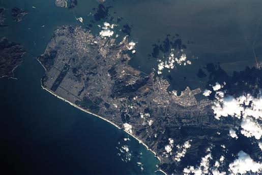
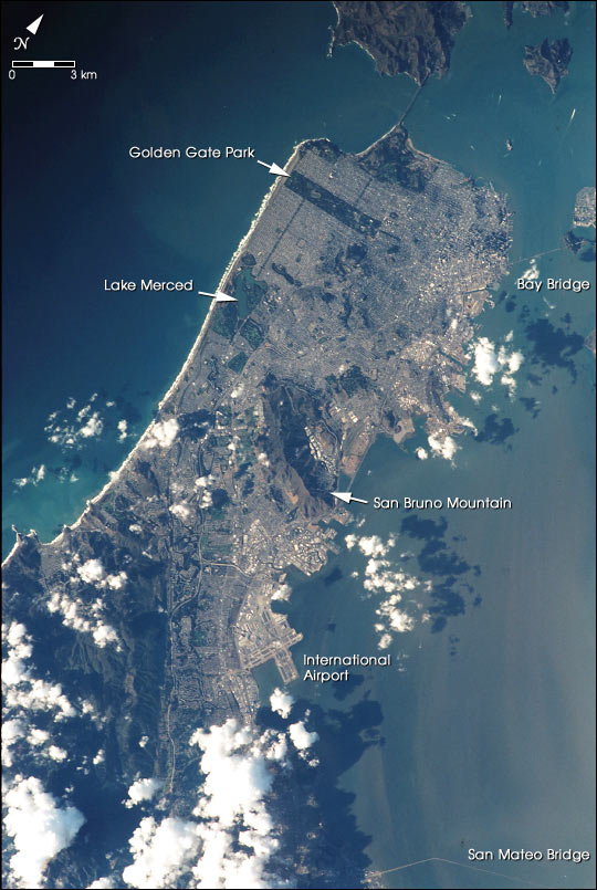
This image shows a photograph of San Francisco taken as the International Space Station passed 383 km overhead on November 10, 2000. It was taken by astronauts looking out one of the station windows using 35 mm film and a 400 mm lens. The view includes the area stretching from the Golden Gate Bridge in the north to the San Mateo Bridge on the southeast.In the full-resolution version major landmarks are easily distinguished, and wider streets such as Van Ness and Geary can be easily distinguished from the less distinct grid of smaller streets. Digitized from film at high resolution, each pixel in this image represents 14.6 m on the ground.
Download Packaged File.
This option downloads the following items, packaged into a single file, if they are available:
- Browse image
- Cataloged information with captions
- Camera file
- Sound file
Server: 2 |
This service is provided by the International Space Station program. |
Recommended Citation: |
||

