| Home >> | Advanced Search >> |
 |
|
Astronaut Photography of Earth - Display Record
ISS008-E-20656

Low-resolution Browse Image
(Most browse images are not color adjusted.)Images
Conditions for Use of Images >>Image Transformation Tutorial >> Saving, Color Adjusting, and Printing Images >>
Images to View on Your Computer Now
| File Name | File Size (bytes) | Width | Height | Annotated | Cropped | Purpose | Comments | |
|---|---|---|---|---|---|---|---|---|
| View | ISS008-E-20656.JPG | 71943 | 639 | 435 | No | No | ||
| View | ISS008-E-20656.JPG | 79695 | 539 | 334 | NASA's Earth Observatory web site | |||
| View | ISS008-E-20656_2.JPG | 917098 | 1004 | 1516 | NASA's Earth Observatory web site | |||
| View | ISS008-E-20656.JPG | 2402429 | 1000 | 1605 | No | Yes | NASA's Earth Observatory web site | Color adjusted |
Large Images to Request for Downloading
| File Name | File Size (bytes) | Width | Height | Annotated | Cropped | Purpose | Comments | |
|---|---|---|---|---|---|---|---|---|
| Request | ISS008-E-20656.JPG | 1003661 | 3032 | 2064 | No | No | ||
| Request | ISS008-E-20656.JPG | 5972667 | 1992 | 3032 | No | No | NASA's Earth Observatory web site | Color adjusted |
Download a Keyhole Markup Language (KML) file for use in Google Earth.
Electronic Image Data
Camera Files >> No sound file available.Identification
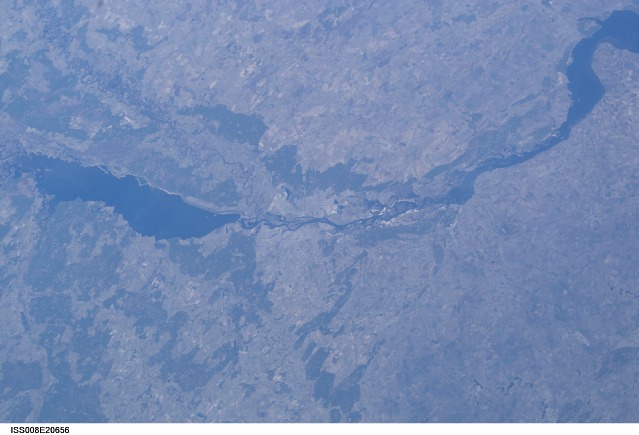
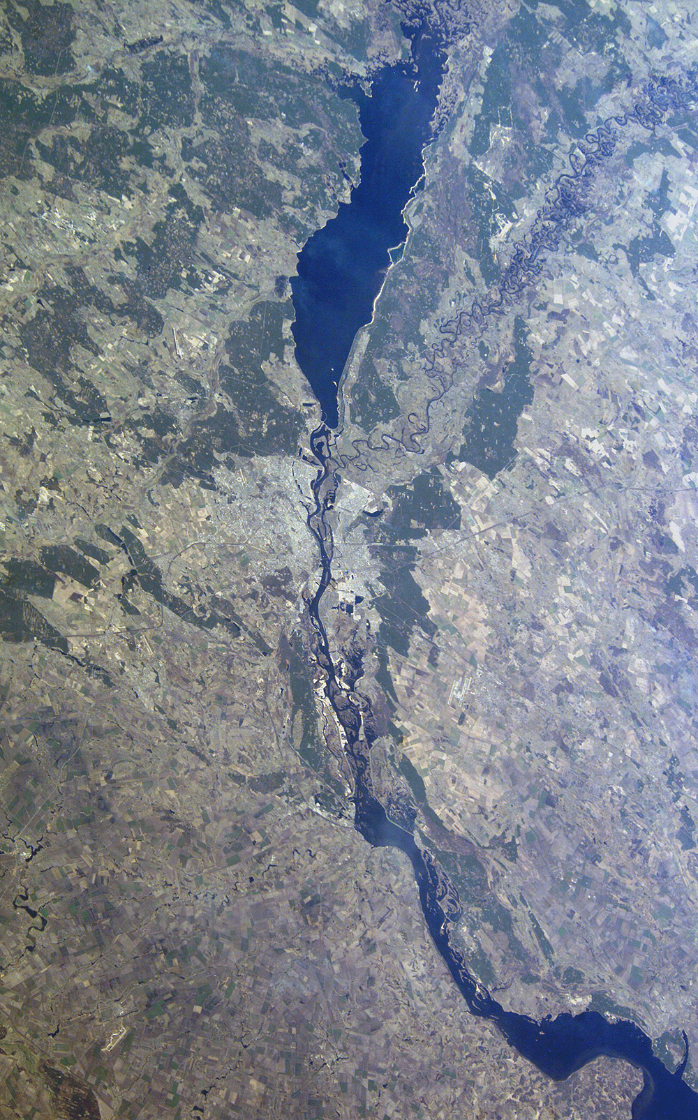
Mission: ISS008 Roll: E Frame: 20656 Mission ID on the Film or image: ISS008Country or Geographic Name: UKRAINE
Features: KIEV, DNEPR RIVER, RESERVOIRS
Center Point Latitude: 50.5 Center Point Longitude: 30.5 (Negative numbers indicate south for latitude and west for longitude)
Stereo: (Yes indicates there is an adjacent picture of the same area)
ONC Map ID: JNC Map ID:
Camera
Camera Tilt: 30Camera Focal Length: 80mm
Camera: E4: Kodak DCS760C Electronic Still Camera
Film: 3060E : 3060 x 2036 pixel CCD, RGBG array.
Quality
Film Exposure:Percentage of Cloud Cover: 10 (0-10)
Nadir
Date: 20040404 (YYYYMMDD)GMT Time: 121239 (HHMMSS)Nadir Point Latitude: 49.5, Longitude: 32.1 (Negative numbers indicate south for latitude and west for longitude)
Nadir to Photo Center Direction: Northwest
Sun Azimuth: 226 (Clockwise angle in degrees from north to the sun measured at the nadir point)
Spacecraft Altitude: 193 nautical miles (357 km)
Sun Elevation Angle: 38 (Angle in degrees between the horizon and the sun, measured at the nadir point)
Orbit Number: 2675
Captions
Kiev, Ukraine:Last week, The International Space Station Expedition 8 crew took a series of images of the Ukrainian city of Kiev on a reservoir on the Dneiper River. Kiev is the capital of Ukraine and home to nearly 3 million people.
Kiev is rich in the history of western civilization. It was a trade center on the Baltic-Black Sea route in the 11th and 12th centuries, and one of the major cities in the Christian world, until Mongol invaders destroyed the city in 1240. Some of the 11th-century cathedrals, which contain famous artifacts, remain standing and have been restored. Throughout the Middle Ages, Kiev suffered through different occupations, but rose to be the center of Russian Orthodox Christianity by the 1800s. This cosmopolitan city was again largely destroyed during World War II. Despite its turbulent history, many of Kiev’s world famous artifacts have been rebuilt, and the city is prominent as a cultural center.
Download Packaged File.
This option downloads the following items, packaged into a single file, if they are available:
- Browse image
- Cataloged information with captions
- Camera file
- Sound file
Server: 2 |
This service is provided by the International Space Station program. |
Recommended Citation: |
||

