| Home >> | Advanced Search >> |
 |
|
Astronaut Photography of Earth - Display Record
ISS016-E-19394
Low-resolution Browse Image
(Most browse images are not color adjusted.)Images
Conditions for Use of Images >>Image Transformation Tutorial >> Saving, Color Adjusting, and Printing Images >>
Images to View on Your Computer Now
| File Name | File Size (bytes) | Width | Height | Annotated | Cropped | Purpose | Comments | |
|---|---|---|---|---|---|---|---|---|
| View | ISS016-E-19394.JPG | 67437 | 639 | 435 | No | No | ||
| View | ISS016-E-19394.JPG | 266407 | 540 | 357 | Yes | Yes | NASA's Earth Observatory web site |
Large Images to Request for Downloading
| File Name | File Size (bytes) | Width | Height | Annotated | Cropped | Purpose | Comments | |
|---|---|---|---|---|---|---|---|---|
| Request | ISS016-E-19394.JPG | 736311 | 1000 | 661 | No | Yes | NASA's Earth Observatory web site | |
| Request | ISS016-E-19394.JPG | 1060822 | 3032 | 2064 | No | No |
Download a Keyhole Markup Language (KML) file for use in Google Earth.
Electronic Image Data
Camera Files >> No sound file available.Identification
Mission: ISS016 Roll: E Frame: 19394 Mission ID on the Film or image: ISS016Country or Geographic Name: SAUDI ARABIA
Features: RED SEA, AL WADJ BANK, CORAL REEF
Center Point Latitude: 25.4 Center Point Longitude: 36.8 (Negative numbers indicate south for latitude and west for longitude)
Stereo: (Yes indicates there is an adjacent picture of the same area)
ONC Map ID: JNC Map ID:
Camera
Camera Tilt: 28Camera Focal Length: 800mm
Camera: E4: Kodak DCS760C Electronic Still Camera
Film: 3060E : 3060 x 2036 pixel CCD, RGBG array.
Quality
Film Exposure:Percentage of Cloud Cover: 10 (0-10)
Nadir
Date: 20071230 (YYYYMMDD)GMT Time: 125513 (HHMMSS)Nadir Point Latitude: 26.6, Longitude: 35.7 (Negative numbers indicate south for latitude and west for longitude)
Nadir to Photo Center Direction: Southeast
Sun Azimuth: 228 (Clockwise angle in degrees from north to the sun measured at the nadir point)
Spacecraft Altitude: 180 nautical miles (333 km)
Sun Elevation Angle: 21 (Angle in degrees between the horizon and the sun, measured at the nadir point)
Orbit Number: 175
Captions
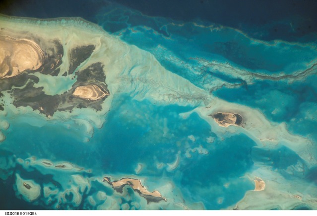
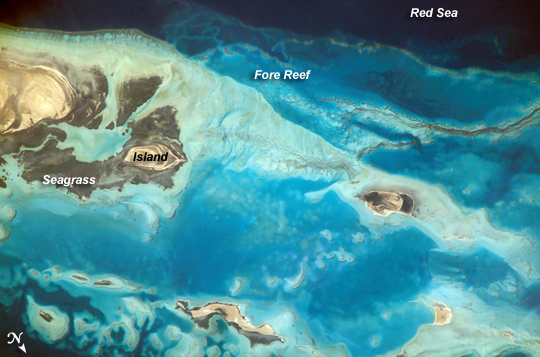
Al Wadj Bank, Saudi ArabiaSaudi Arabia boasts the most coral reefs of any Middle Eastern country, as it includes coastline along both the Red Sea and the Gulf of Arabia. This high-resolution astronaut photograph shows part of the Al Wadj Bank, located along the northern Red Sea coast. Despite the relatively high salinity of Red Sea water (compared to other oceans), approximately 260 species of coral have been documented in the region. Large tracts of the Saudi Arabian coastline are undeveloped, and reefs in these areas are in generally good ecological health. However, reefs located near large urban centers such as Jeddeh have suffered degradation due to land reclamation (dredging and filling), pollution, and increased sediment runoff from land.
The Al Wadj Bank (a bank is an underwater hill) includes a healthy and diverse reef system, extensive seagrass beds, and perhaps the largest population of dugong--a marine mammal similar to the North American manatee--in the eastern Red Sea. The portion of the Bank in this image illustrates the complex form and topography of the reef system. Several emergent islands (tan) are visible, surrounded primarily by dark green seagrass; the largest is at top left. Only the islands are above the waterline; over the reefs, the water color ranges from light teal (shallow) to turquoise (increasing depth). The southern edge of the reef is well defined by the deep, dark blue water of the Red Sea (top).
In recent years, countries that border the Red Sea have cooperated to form a regional conservation plan for reef ecosystems. The plan includes the designation of several Marine Protected Areas (MPAs), integrated coastal management plans, improved pollution controls, reef health monitoring, and public education efforts. The Al Wadj Bank is one of the areas designated as a MPA.
Download Packaged File.
This option downloads the following items, packaged into a single file, if they are available:
- Browse image
- Cataloged information with captions
- Camera file
- Sound file
Server: 2 |
This service is provided by the International Space Station program. |
Recommended Citation: |
||

