| Home >> | Advanced Search >> |
 |
|
Astronaut Photography of Earth - Display Record
ISS006-E-19300
Low-resolution Browse Image
(Most browse images are not color adjusted.)Images
Conditions for Use of Images >>Image Transformation Tutorial >> Saving, Color Adjusting, and Printing Images >>
Images to View on Your Computer Now
| File Name | File Size (bytes) | Width | Height | Annotated | Cropped | Purpose | Comments | |
|---|---|---|---|---|---|---|---|---|
| View | ISS006-E-19300.JPG | 50841 | 639 | 435 | No | No | ||
| View | ISS006-E-19300.JPG | 54172 | 540 | 414 | Photographic Highlights | (540 px resized images) | ||
| View | ISS006-E-19300.JPG | 75415 | 540 | 358 | No | No | NASA's Earth Observatory web site | |
| View | ISS006-E-19300.JPG | 730999 | 1000 | 681 | No | No | NASA's Earth Observatory web site |
Large Images to Request for Downloading
| File Name | File Size (bytes) | Width | Height | Annotated | Cropped | Purpose | Comments | |
|---|---|---|---|---|---|---|---|---|
| Request | ISS006-E-19300.JPG | 180757 | 1024 | 786 | Photographic Highlights | (actual files used) | ||
| Request | ISS006-E-19300.JPG | 647772 | 3032 | 2064 | No | No | ||
| Request | ISS006-E-19300.JPG | 3298371 | 3032 | 2064 | No | No | NASA's Earth Observatory web site |
Download a Keyhole Markup Language (KML) file for use in Google Earth.
Electronic Image Data
Camera Files >> Audio file >>Identification
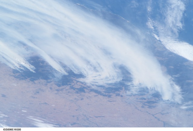
Mission: ISS006 Roll: E Frame: 19300 Mission ID on the Film or image: ISS006Country or Geographic Name: AUSTRALIA-NSW
Features: BUSHFIRES, SMOKE
Center Point Latitude: -36.0 Center Point Longitude: 148.5 (Negative numbers indicate south for latitude and west for longitude)
Stereo: (Yes indicates there is an adjacent picture of the same area)
ONC Map ID: JNC Map ID:
Camera
Camera Tilt: Low ObliqueCamera Focal Length: 85mm
Camera: E4: Kodak DCS760C Electronic Still Camera
Film: 3060E : 3060 x 2036 pixel CCD, RGBG array.
Quality
Film Exposure:Percentage of Cloud Cover: 25 (11-25)
Nadir
Date: 20030118 (YYYYMMDD)GMT Time: 00____ (HHMMSS)Nadir Point Latitude: , Longitude: (Negative numbers indicate south for latitude and west for longitude)
Nadir to Photo Center Direction:
Sun Azimuth: (Clockwise angle in degrees from north to the sun measured at the nadir point)
Spacecraft Altitude: nautical miles (0 km)
Sun Elevation Angle: (Angle in degrees between the horizon and the sun, measured at the nadir point)
Orbit Number:
Captions
For nearly six weeks now, southeastern Australia has been experiencing an unprecedented bushfire emergency. Following months of regional drought, the worst in 50 years, this summer’s fire season has resulted in numerous large fires over much of the Great Dividing Range as well as an enormous smoke pall over New South Wales, Victoria, and the adjacent South Pacific Ocean. The fires have advanced from the lower foothills of the interior to higher elevations, recently threatening ski resorts in the Snowy Mountains.The crew of the International Space Station took this dramatic image of the fires on the morning of January 18, 2003. Brisk winds are sweeping smoke plumes eastward off the Australian coast north of Cape Howe. The agricultural valleys of the Murrumbidgee and Murray Rivers give way to the burning, darker bush areas of the mountains with the extreme eastern coastline of Victoria visible beyond. Images like these are a unique contribution to our understanding of dynamic events — made possible by the human observer in orbit.
Download Packaged File.
This option downloads the following items, packaged into a single file, if they are available:
- Browse image
- Cataloged information with captions
- Camera file
- Sound file
Server: 2 |
This service is provided by the International Space Station program. |
Recommended Citation: |
||

