| Home >> | Advanced Search >> |
 |
|
Astronaut Photography of Earth - Display Record
ISS016-E-19239
Low-resolution Browse Image
(Most browse images are not color adjusted.)Images
Conditions for Use of Images >>Image Transformation Tutorial >> Saving, Color Adjusting, and Printing Images >>
Images to View on Your Computer Now
| File Name | File Size (bytes) | Width | Height | Annotated | Cropped | Purpose | Comments | |
|---|---|---|---|---|---|---|---|---|
| View | ISS016-E-19239.JPG | 119208 | 639 | 435 | No | No | ||
| View | ISS016-E-19239.JPG | 352879 | 540 | 354 | Yes | Yes | NASA's Earth Observatory web site |
Large Images to Request for Downloading
| File Name | File Size (bytes) | Width | Height | Annotated | Cropped | Purpose | Comments | |
|---|---|---|---|---|---|---|---|---|
| Request | ISS016-E-19239.JPG | 1039454 | 1000 | 655 | No | Yes | NASA's Earth Observatory web site | |
| Request | ISS016-E-19239.JPG | 1564732 | 3032 | 2064 | No | No |
Download a Keyhole Markup Language (KML) file for use in Google Earth.
Electronic Image Data
Camera Files >> No sound file available.Identification
Mission: ISS016 Roll: E Frame: 19239 Mission ID on the Film or image: ISS016Country or Geographic Name: ETHIOPIA
Features: BEDADA TOLA,ENYO,CRATER
Center Point Latitude: 8.8 Center Point Longitude: 38.0 (Negative numbers indicate south for latitude and west for longitude)
Stereo: (Yes indicates there is an adjacent picture of the same area)
ONC Map ID: JNC Map ID:
Camera
Camera Tilt: 31Camera Focal Length: 400mm
Camera: E4: Kodak DCS760C Electronic Still Camera
Film: 3060E : 3060 x 2036 pixel CCD, RGBG array.
Quality
Film Exposure:Percentage of Cloud Cover: 10 (0-10)
Nadir
Date: 20071229 (YYYYMMDD)GMT Time: 141257 (HHMMSS)Nadir Point Latitude: 10.4, Longitude: 37.1 (Negative numbers indicate south for latitude and west for longitude)
Nadir to Photo Center Direction: Southeast
Sun Azimuth: 243 (Clockwise angle in degrees from north to the sun measured at the nadir point)
Spacecraft Altitude: 181 nautical miles (335 km)
Sun Elevation Angle: 14 (Angle in degrees between the horizon and the sun, measured at the nadir point)
Orbit Number: 160
Captions
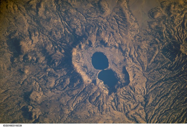
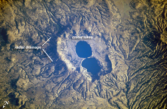
Dendi Caldera, EthiopiaThe Dendi Caldera is located on the Ethiopian Plateau, approximately 86 km to the southwest of Addis Ababa. A caldera is a geological feature formed by the near-total eruption of magma from beneath a volcano, leading to collapse of the volcanic structure into the now-empty magma chamber. This collapse typically leaves a crater or depression where the volcano stood, and later volcanic activity can fill the caldera with younger lavas, ash, pyroclastic rocks, and sediments. While much of the volcanic rock in the area is comprised of basalt erupted as part of the opening of the East African Rift, more silica-rich rock types (characterized by minerals such as quartz and feldspar) are also present.
The approximately 4 km wide Dendi Caldera includes some of this silica-rich volcanic rock – the rim of the caldera, visible in this astronaut photograph, is comprised mainly of poorly-consolidated ash erupted during the Tertiary Period (approximately 65 – 2 million years ago).A notable feature of the Dendi Caldera is the presence of two shallow lakes formed within the central depression (image center). This image also highlights a radial drainage pattern surrounding the remnants of the Dendi volcanic cone. Such patterns typically form around volcanoes, as rainfall has equal potential to move downslope on all sides of the cone and incise channels. No historical volcanic eruptions of Dendi are recorded, however the Wonchi Caldera 13 km to the southwest (not shown) may have been active as recently as A.D. 550.
Download Packaged File.
This option downloads the following items, packaged into a single file, if they are available:
- Browse image
- Cataloged information with captions
- Camera file
- Sound file
Server: 2 |
This service is provided by the International Space Station program. |
Recommended Citation: |
||

