| Home >> | Advanced Search >> |
 |
|
Astronaut Photography of Earth - Display Record
ISS012-E-19051

Low-resolution Browse Image
(Most browse images are not color adjusted.)Images
Conditions for Use of Images >>Image Transformation Tutorial >> Saving, Color Adjusting, and Printing Images >>
Images to View on Your Computer Now
| File Name | File Size (bytes) | Width | Height | Annotated | Cropped | Purpose | Comments | |
|---|---|---|---|---|---|---|---|---|
| View | ISS012-E-19051.JPG | 58911 | 639 | 435 | No | No | ||
| View | ISS012-E-19051.JPG | 243416 | 540 | 392 | Yes | Yes | NASA's Earth Observatory web site |
Large Images to Request for Downloading
| File Name | File Size (bytes) | Width | Height | Annotated | Cropped | Purpose | Comments | |
|---|---|---|---|---|---|---|---|---|
| Request | ISS012-E-19051.JPG | 630230 | 1000 | 725 | No | Yes | NASA's Earth Observatory web site | |
| Request | ISS012-E-19051.JPG | 939361 | 3032 | 2064 | No | No |
Download a Keyhole Markup Language (KML) file for use in Google Earth.
Electronic Image Data
Camera Files >> No sound file available.Identification
Mission: ISS012 Roll: E Frame: 19051 Mission ID on the Film or image: ISS012Country or Geographic Name: USA-RHODE ISLAND
Features: NEWPORT,FLINT POINT
Center Point Latitude: 41.5 Center Point Longitude: -71.3 (Negative numbers indicate south for latitude and west for longitude)
Stereo: (Yes indicates there is an adjacent picture of the same area)
ONC Map ID: JNC Map ID:
Camera
Camera Tilt: 28Camera Focal Length: 800mm
Camera: E4: Kodak DCS760C Electronic Still Camera
Film: 3060E : 3060 x 2036 pixel CCD, RGBG array.
Quality
Film Exposure:Percentage of Cloud Cover: 10 (0-10)
Nadir
Date: 20060304 (YYYYMMDD)GMT Time: 210427 (HHMMSS)Nadir Point Latitude: 41.9, Longitude: -69.7 (Negative numbers indicate south for latitude and west for longitude)
Nadir to Photo Center Direction: West
Sun Azimuth: 247 (Clockwise angle in degrees from north to the sun measured at the nadir point)
Spacecraft Altitude: 185 nautical miles (343 km)
Sun Elevation Angle: 15 (Angle in degrees between the horizon and the sun, measured at the nadir point)
Orbit Number: 1672
Captions
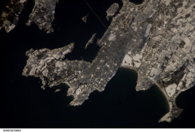
Newport, Rhode IslandNewport, Rhode Island, is well known as a summer destination, but winter snow blankets the city of Newport in this astronaut photograph. One of the first European settlements in the Americas, the region was initially populated by colonists seeking religious freedom denied them in Europe. Founded in 1639, Newport became a bastion of the Baptist faith but also exemplified one of the basic precepts of the United States Constitution—separation of church and state. Throughout the 17th and 18th centuries, Newport consolidated its position as one of the premier ports of the United States. The 19th and early 20th centuries saw a decline in commercial shipping at Newport and its rebirth as a recreational destination. Many of the leading industrialist families of the time, such as the Vanderbilts, built grand summer mansions that are now open to visitors.
The United States Navy has also had a strong presence in the Newport area since 1869, exemplified by the establishment of the Naval War College, shown at top center. The college, established in 1884, is still the premier educational institution for naval officers. The gray-brown metropolitan area of Newport contrasts sharply with the surrounding snow-covered open fields and rural areas to the east and southwest. The Clairborne Pell (also known as Newport) Bridge connects Jamestown, Rhode Island (on Conanicut Island) to Newport, shown at top. The main span of this suspension bridge is 485 meters (1,600 feet) long, and it crosses the East Passage of Narragansett Bay. The Sachuest Point National Wildlife Refuge, shown at lower right, supports over 200 bird species, including the largest winter harlequin duck population on the East Coast.
Download Packaged File.
This option downloads the following items, packaged into a single file, if they are available:
- Browse image
- Cataloged information with captions
- Camera file
- Sound file
Server: 2 |
This service is provided by the International Space Station program. |
Recommended Citation: |
||

