| Home >> | Advanced Search >> |
 |
|
Astronaut Photography of Earth - Display Record
ISS005-E-18511
Low-resolution Browse Image
(Most browse images are not color adjusted.)Images
Conditions for Use of Images >>Image Transformation Tutorial >> Saving, Color Adjusting, and Printing Images >>
Images to View on Your Computer Now
| File Name | File Size (bytes) | Width | Height | Annotated | Cropped | Purpose | Comments | |
|---|---|---|---|---|---|---|---|---|
| View | ISS005-E-18511.JPG | 78466 | 540 | 405 | Yes | Earth From Space collection | ||
| View | ISS005-E-18511.JPG | 105240 | 639 | 435 | No | No |
Large Images to Request for Downloading
| File Name | File Size (bytes) | Width | Height | Annotated | Cropped | Purpose | Comments | |
|---|---|---|---|---|---|---|---|---|
| Request | ISS005-E-18511.JPG | 1599567 | 3032 | 2064 | No | No |
Download a Keyhole Markup Language (KML) file for use in Google Earth.
Electronic Image Data
Camera Files >> No sound file available.Identification
Mission: ISS005 Roll: E Frame: 18511 Mission ID on the Film or image: ISS005Country or Geographic Name: USA-WASHINGTON
Features: MOUNT ST. HELENS
Center Point Latitude: 46.2 Center Point Longitude: -122.2 (Negative numbers indicate south for latitude and west for longitude)
Stereo: (Yes indicates there is an adjacent picture of the same area)
ONC Map ID: JNC Map ID:
Camera
Camera Tilt: 37Camera Focal Length: 800mm
Camera: E4: Kodak DCS760C Electronic Still Camera
Film: 3060E : 3060 x 2036 pixel CCD, RGBG array.
Quality
Film Exposure:Percentage of Cloud Cover: 10 (0-10)
Nadir
Date: 20021025 (YYYYMMDD)GMT Time: 220846 (HHMMSS)Nadir Point Latitude: 46.1, Longitude: -124.8 (Negative numbers indicate south for latitude and west for longitude)
Nadir to Photo Center Direction: East
Sun Azimuth: 214 (Clockwise angle in degrees from north to the sun measured at the nadir point)
Spacecraft Altitude: 206 nautical miles (382 km)
Sun Elevation Angle: 25 (Angle in degrees between the horizon and the sun, measured at the nadir point)
Orbit Number: 2446
Captions
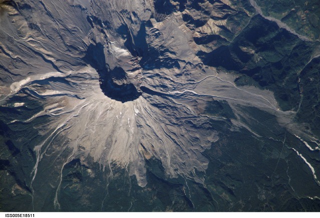
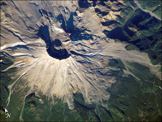
Mount St. Helens, Washington:On May 18, 1980, Mount Saint Helens volcano erupted. A series of earthquakes preceded the eruption, triggering a collapse of the north side of the mountain into a massive landslide. This avalanche coincided with a huge explosion that destroyed over 700 square kilometers (270 square miles) of forest in a few seconds, and sent a billowing cloud of ash and smoke 24,000 meters (80,000 feet) into the atmosphere. Because the eruption occurred in an easily accessible region of the U.S., Mount St. Helens has provided unprecedented opportunities for US researchers to collect scientific observations of the geology of an active volcano and document the regional ecological impact and recovery from an eruption.
This week marks twenty four years since the eruption. On an earlier Space Station expedition, astronauts observed and captured this detailed image of the volcano’s summit caldera. In the center of the crater sits a lava dome that is 876 feet above the crater floor and is about 3,500 feet in diameter. The dome began to form after the 1980 eruption, but there have been no dome building eruptions for more than a decade. Afternoon lighting accents the flow features in the volcanic and debris flows and the steep valleys eroded into the loosely consolidated material near the summit.
The upper slopes of the 1980 blast zone begin at the gray colored region that extends north (upper left) from the summit of the volcano. The volcanic mud and debris from the eruption choked all of the drainages in the region. The deeply incised valley to the left (west) is the uppermost reach of the South Fork of the Toutle River. Devastating mudslides buried the original Toutle River Valley to an average depth of 150 feet, but in places up to 600 feet. Even today, heavy precipitation can send unconsolidated volcanic debris downstream. A special dam was constructed on the North Fork of the Toutle River to catch the sediments from moving further downstream. Levees and dredging also help stem further mudslides. The dark green area south of the blast zone is the thickly forested region of the Gifford Pinchot National Forest.
links:
USGS Cascade Volcano Observatory
STS064-51-25 (wide-angle photograph from the Space Shuttle)
Mount St. Helens and Spirit Lake
Landsat-7 view of Mount St. Helens
Download Packaged File.
This option downloads the following items, packaged into a single file, if they are available:
- Browse image
- Cataloged information with captions
- Camera file
- Sound file
Server: 2 |
This service is provided by the International Space Station program. |
Recommended Citation: |
||

