| Home >> | Advanced Search >> |
 |
|
Astronaut Photography of Earth - Display Record
ISS005-E-18039

Low-resolution Browse Image
(Most browse images are not color adjusted.)Images
Conditions for Use of Images >>Image Transformation Tutorial >> Saving, Color Adjusting, and Printing Images >>
Images to View on Your Computer Now
| File Name | File Size (bytes) | Width | Height | Annotated | Cropped | Purpose | Comments | |
|---|---|---|---|---|---|---|---|---|
| View | ISS005-E-18039.JPG | 61372 | 540 | 451 | Yes | Yes | NASA's Earth Observatory web site | |
| View | ISS005-E-18039.JPG | 65740 | 639 | 435 | No | No | From STIC, color adjusted | |
| View | ISS005-E-18039.JPG | 236225 | 540 | 405 | Photographic Highlights | (540 px resized images) | ||
| View | ISS005-E-18039.JPG | 648912 | 1000 | 702 | No | Yes | NASA's Earth Observatory web site |
Large Images to Request for Downloading
| File Name | File Size (bytes) | Width | Height | Annotated | Cropped | Purpose | Comments | |
|---|---|---|---|---|---|---|---|---|
| Request | ISS005-E-18039.JPG | 746200 | 1024 | 768 | Photographic Highlights | (actual files used) | ||
| Request | ISS005-E-18039.JPG | 1421881 | 3032 | 2064 | No | No | From STIC, color adjusted |
Download a Keyhole Markup Language (KML) file for use in Google Earth.
Electronic Image Data
Camera Files >> No sound file available.Identification
Mission: ISS005 Roll: E Frame: 18039 Mission ID on the Film or image: ISS005Country or Geographic Name: USA-FLORIDA
Features: KEY WEST
Center Point Latitude: 24.5 Center Point Longitude: -82.0 (Negative numbers indicate south for latitude and west for longitude)
Stereo: (Yes indicates there is an adjacent picture of the same area)
ONC Map ID: JNC Map ID:
Camera
Camera Tilt: 5Camera Focal Length: 800mm
Camera: E4: Kodak DCS760C Electronic Still Camera
Film: 3060E : 3060 x 2036 pixel CCD, RGBG array.
Quality
Film Exposure:Percentage of Cloud Cover: 10 (0-10)
Nadir
Date: 20021022 (YYYYMMDD)GMT Time: 134232 (HHMMSS)Nadir Point Latitude: 24.8, Longitude: -81.9 (Negative numbers indicate south for latitude and west for longitude)
Nadir to Photo Center Direction: South
Sun Azimuth: 119 (Clockwise angle in degrees from north to the sun measured at the nadir point)
Spacecraft Altitude: 207 nautical miles (383 km)
Sun Elevation Angle: 28 (Angle in degrees between the horizon and the sun, measured at the nadir point)
Orbit Number: 2394
Captions
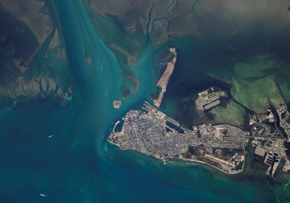
Turquoise blue waters, coral reefs and sandy beaches were apparently on the minds of International Space Station astronauts last week. As they passed over the Florida Keys, they acquired a sequence of images from Key West eastward along the outer keys. The detail of the images showcases the clarity of the Caribbean waters, and allows for mapping of both land use and shallow marine features. This image of Key West shows the intensive built-up area of the town, the offshore sand flats and grassbeds surrounding Key West, the patterns of natural tidal channels and artificially dredged channels that allow boat access to the local marinas.Download Packaged File.
This option downloads the following items, packaged into a single file, if they are available:
- Browse image
- Cataloged information with captions
- Camera file
- Sound file
Server: 2 |
This service is provided by the International Space Station program. |
Recommended Citation: |
||

