| Home >> | Advanced Search >> |
 |
|
Astronaut Photography of Earth - Display Record
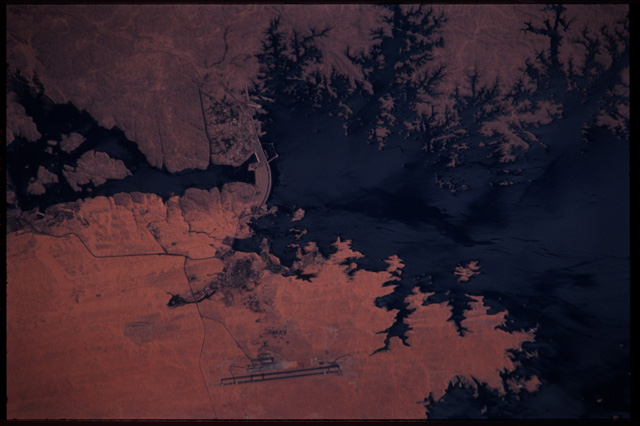
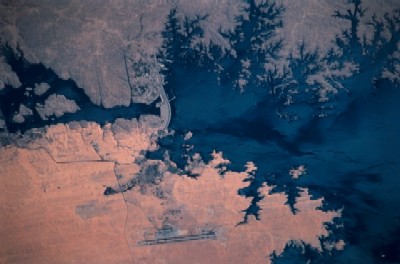
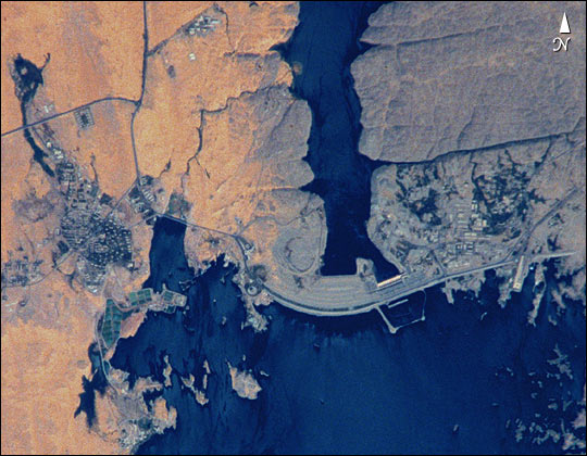
STS102-303-17
Low-resolution Browse Image
(Most browse images are not color adjusted.)Images
Conditions for Use of Images >>Image Transformation Tutorial >> Saving, Color Adjusting, and Printing Images >>
Images to View on Your Computer Now
| File Name | File Size (bytes) | Width | Height | Annotated | Cropped | Purpose | Comments | |
|---|---|---|---|---|---|---|---|---|
| View | STS102-303-17.JPG | 31118 | 400 | 264 | No | No | Photographic Highlights | |
| View | STS102-303-17.JPG | 69192 | 540 | 420 | Yes | Yes | NASA's Earth Observatory web site | |
| View | STS102-303-17_2.JPG | 91510 | 640 | 426 | No | No | From ISD Web Gallery CDs |
Large Images to Request for Downloading
| File Name | File Size (bytes) | Width | Height | Annotated | Cropped | Purpose | Comments | |
|---|---|---|---|---|---|---|---|---|
| Request | STS102-303-17.JPG | 1290703 | 2970 | 1960 | No | No | ||
| Request | STS102-303-17.TIF | 18831656 | 3070 | 2044 | No | No | Scientist Request |
Download a Keyhole Markup Language (KML) file for use in Google Earth.
Electronic Image Data
Camera files only apply to electronic still cameras.No sound file available.
Identification
Mission: STS102 Roll: 303 Frame: 17 Mission ID on the Film or image: STS102Country or Geographic Name: EGYPT
Features: ASWAN HIGH DAM, LAKE NASSER
Center Point Latitude: 24.0 Center Point Longitude: 33.0 (Negative numbers indicate south for latitude and west for longitude)
Stereo: (Yes indicates there is an adjacent picture of the same area)
ONC Map ID: JNC Map ID:
Camera
Camera Tilt: 21Camera Focal Length: 110mm
Camera: NK: Nikon 35mm film camera
Film:
Quality
Film Exposure:Percentage of Cloud Cover: 10 (0-10)
Nadir
Date: 20010318 (YYYYMMDD)GMT Time: 090921 (HHMMSS)Nadir Point Latitude: 24.7, Longitude: 31.9 (Negative numbers indicate south for latitude and west for longitude)
Nadir to Photo Center Direction: Southeast
Sun Azimuth: 152 (Clockwise angle in degrees from north to the sun measured at the nadir point)
Spacecraft Altitude: 205 nautical miles (380 km)
Sun Elevation Angle: 62 (Angle in degrees between the horizon and the sun, measured at the nadir point)
Orbit Number: 156
Captions
STS102-303-17 Aswan High Dam, EgyptThe Aswan High Dam was completed in 1970 and is one of the largest earthen embankment dams in the world. It is 364 feet (111 m) tall, 12 565 feet (3830 m) long and nearly 3281 feet (1000 m) wide. When it was built the new reservoir required relocation of nearly 100 000 residents and some archaeological sites. Although the reservoir has benefited Egypt by providing power and controlling floods, it has also had detrimental effects on the Nile system. Before the dam, an estimated 110 million tons of silt was deposited by the annual flood of the Nile, enriching agricultural lands and maintaining the land of the Nile delta. Now this sediment is trapped behind the dam, requiring artificial fertilization of agricultural lands and leading to erosion and saltwater intrusion where the Nile river meets the Mediterranean Sea.
Download Packaged File.
This option downloads the following items, packaged into a single file, if they are available:
- Browse image
- Cataloged information with captions
- Camera file
- Sound file
Server: 2 |
This service is provided by the International Space Station program. |
Recommended Citation: |
||

