| Home >> | Advanced Search >> |
 |
|
Astronaut Photography of Earth - Display Record
ISS007-E-16525

Low-resolution Browse Image
(Most browse images are not color adjusted.)Images
Conditions for Use of Images >>Image Transformation Tutorial >> Saving, Color Adjusting, and Printing Images >>
Images to View on Your Computer Now
| File Name | File Size (bytes) | Width | Height | Annotated | Cropped | Purpose | Comments | |
|---|---|---|---|---|---|---|---|---|
| View | ISS007-E-16525.JPG | 48960 | 540 | 405 | Photographic Highlights | (resized 540 px images) | ||
| View | ISS007-E-16525.JPG | 69094 | 639 | 435 | No | No | ||
| View | ISS007-E-16525.JPG | 73306 | 540 | 334 | Yes | NASA's Earth Observatory web site | ||
| View | ISS007-E-16525.JPG | 254142 | 335 | 540 | Yes | Yes | NASA's Earth Observatory web site | |
| View | ISS007-E-16525.JPG | 1542278 | 1000 | 1267 | No | Yes | NASA's Earth Observatory web site | Color adjusted |
| View | ISS007-E-16525_2.JPG | 2698628 | 1577 | 1998 | No | Yes | NASA's Earth Observatory web site | Color adjusted |
Large Images to Request for Downloading
| File Name | File Size (bytes) | Width | Height | Annotated | Cropped | Purpose | Comments | |
|---|---|---|---|---|---|---|---|---|
| Request | ISS007-E-16525.JPG | 216678 | 1024 | 768 | Photographic Highlights | (actual files used) | ||
| Request | ISS007-E-16525.JPG | 681769 | 1000 | 621 | No | Yes | NASA's Earth Observatory web site | |
| Request | ISS007-E-16525.JPG | 1614177 | 3032 | 2064 | No | No | ||
| Request | ISS007-E-16525_2.JPG | 5689940 | 6144 | 4068 | No | No | Presentation | Earth Sciences Results Briefing/Ed Lu |
Download a Keyhole Markup Language (KML) file for use in Google Earth.
Electronic Image Data
Camera Files >> No sound file available.Identification
Mission: ISS007 Roll: E Frame: 16525 Mission ID on the Film or image: ISS007Country or Geographic Name: USA-ILLINOIS
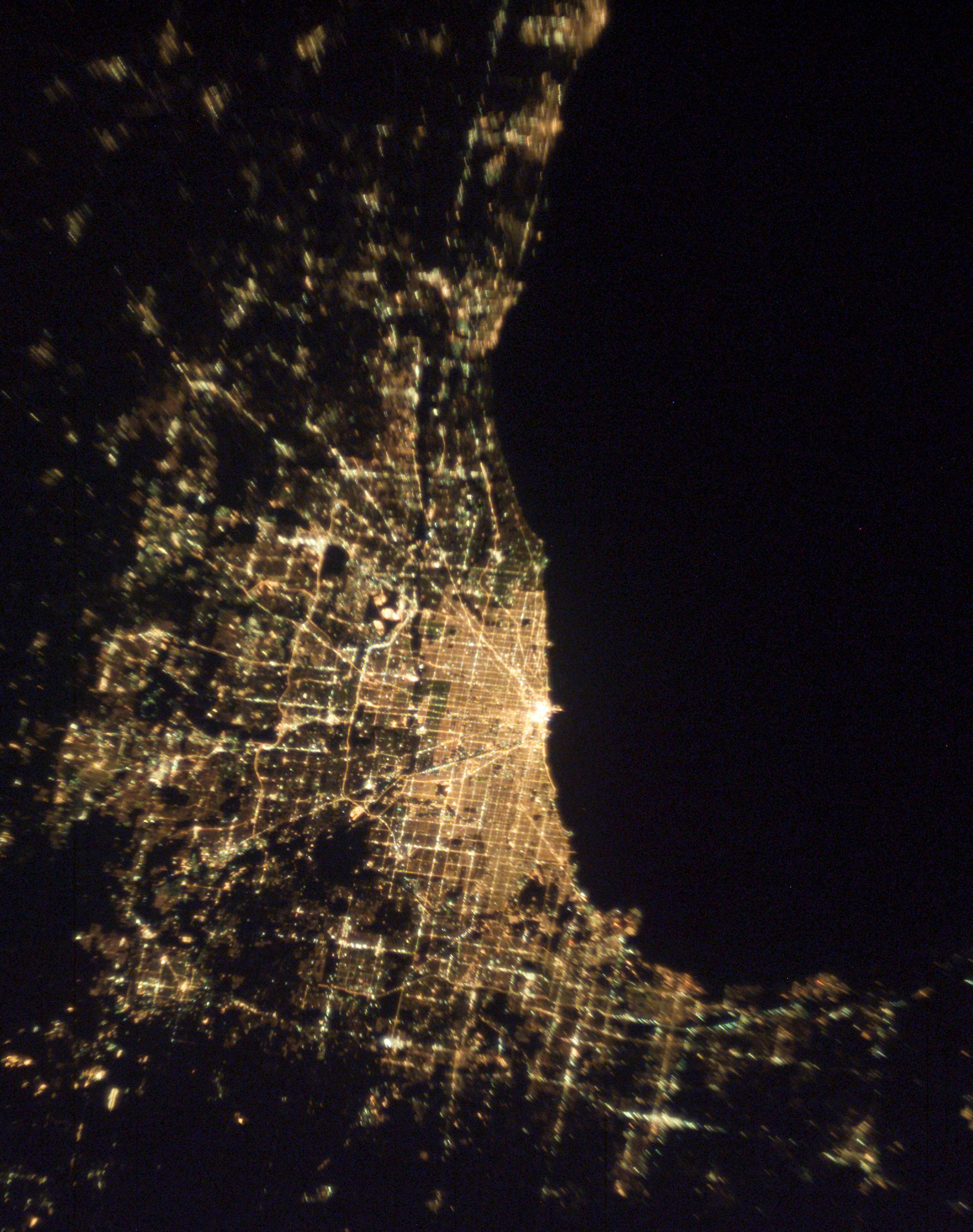
Features: CHICAGO AT NIGHT
Center Point Latitude: 42.0 Center Point Longitude: -87.5 (Negative numbers indicate south for latitude and west for longitude)
Stereo: (Yes indicates there is an adjacent picture of the same area)
ONC Map ID: JNC Map ID:
Camera
Camera Tilt: 14Camera Focal Length: 50mm
Camera: E4: Kodak DCS760C Electronic Still Camera
Film: 3060E : 3060 x 2036 pixel CCD, RGBG array.
Quality
Film Exposure:Percentage of Cloud Cover: 10 (0-10)
Nadir
Date: 20031007 (YYYYMMDD)GMT Time: 013522 (HHMMSS)Nadir Point Latitude: 41.5, Longitude: -86.8 (Negative numbers indicate south for latitude and west for longitude)
Nadir to Photo Center Direction: Northwest
Sun Azimuth: 287 (Clockwise angle in degrees from north to the sun measured at the nadir point)
Spacecraft Altitude: 204 nautical miles (378 km)
Sun Elevation Angle: -26 (Angle in degrees between the horizon and the sun, measured at the nadir point)
Orbit Number: 3848
Captions
Chicago by night. The population of the city of Chicago, IL is roughly 3 million people, but metropolitan Chicago includes nearly 10 million. This image stretches from East Chicago and Gary IND (top center) to Kenosha IL (bottom center). By night, distribution of the region’s 10 million people cannot be missed.Download Packaged File.
This option downloads the following items, packaged into a single file, if they are available:
- Browse image
- Cataloged information with captions
- Camera file
- Sound file
Server: 2 |
This service is provided by the International Space Station program. |
Recommended Citation: |
||

