| Home >> | Advanced Search >> |
 |
|
Astronaut Photography of Earth - Display Record
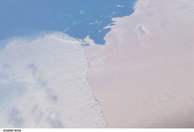
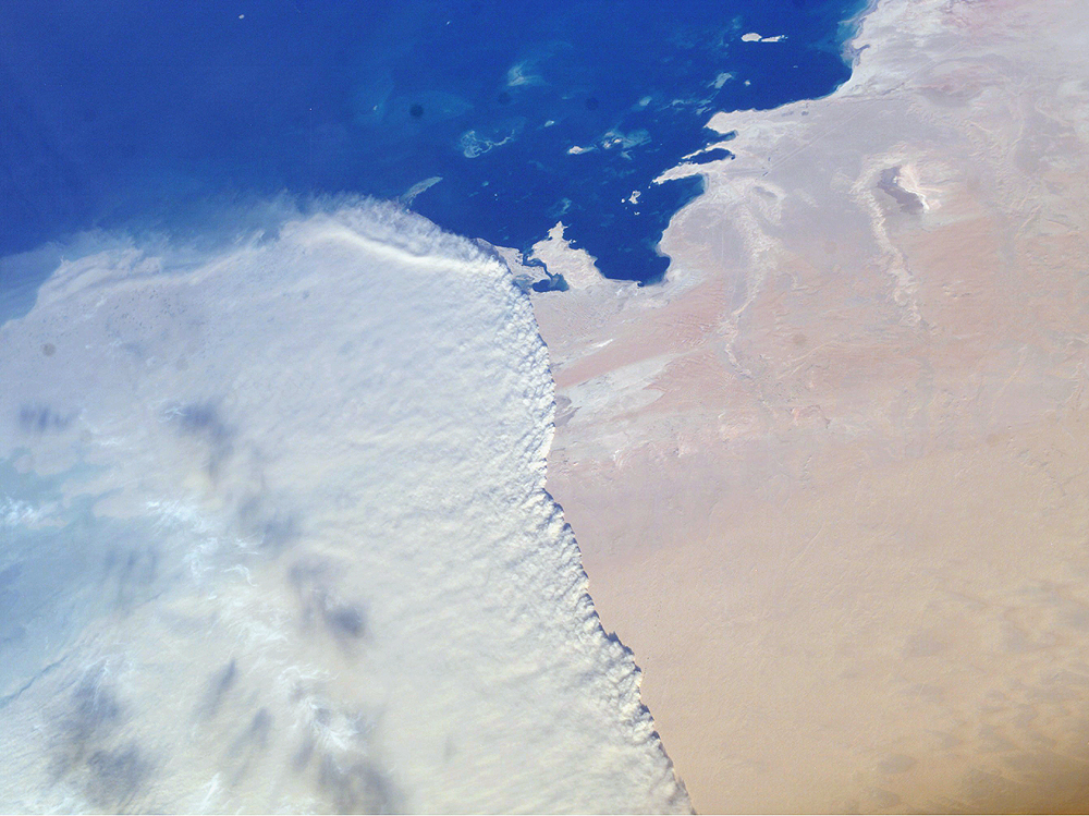
ISS008-E-16355

Low-resolution Browse Image
(Most browse images are not color adjusted.)Images
Conditions for Use of Images >>Image Transformation Tutorial >> Saving, Color Adjusting, and Printing Images >>
Images to View on Your Computer Now
| File Name | File Size (bytes) | Width | Height | Annotated | Cropped | Purpose | Comments | |
|---|---|---|---|---|---|---|---|---|
| View | ISS008-E-16355.JPG | 31117 | 639 | 435 | No | No | ||
| View | ISS008-E-16355.JPG | 72694 | 540 | 404 | No | NASA's Earth Observatory web site | ||
| View | ISS008-E-16355.JPG | 757509 | 1000 | 749 | No | Yes | NASA's Earth Observatory web site | Color adjusted |
Large Images to Request for Downloading
| File Name | File Size (bytes) | Width | Height | Annotated | Cropped | Purpose | Comments | |
|---|---|---|---|---|---|---|---|---|
| Request | ISS008-E-16355.JPG | 479705 | 3032 | 2064 | No | No | ||
| Request | ISS008-E-16355.JPG | 2715102 | 2685 | 2010 | No | No | NASA's Earth Observatory web site | Color adjusted |
Download a Keyhole Markup Language (KML) file for use in Google Earth.
Electronic Image Data
Camera Files >> No sound file available.Identification
Mission: ISS008 Roll: E Frame: 16355 Mission ID on the Film or image: ISS008Country or Geographic Name: SAUDI ARABIA
Features: SAND STORM FRONT, PERSIAN GULF COAST
Center Point Latitude: 24.0 Center Point Longitude: 51.0 (Negative numbers indicate south for latitude and west for longitude)
Stereo: (Yes indicates there is an adjacent picture of the same area)
ONC Map ID: JNC Map ID:
Camera
Camera Tilt: 45Camera Focal Length: 50mm
Camera: E4: Kodak DCS760C Electronic Still Camera
Film: 3060E : 3060 x 2036 pixel CCD, RGBG array.
Quality
Film Exposure:Percentage of Cloud Cover: 50 (26-50)
Nadir
Date: 20040215 (YYYYMMDD)GMT Time: 131112 (HHMMSS)Nadir Point Latitude: 21.0, Longitude: 49.8 (Negative numbers indicate south for latitude and west for longitude)
Nadir to Photo Center Direction: North
Sun Azimuth: 248 (Clockwise angle in degrees from north to the sun measured at the nadir point)
Spacecraft Altitude: 194 nautical miles (359 km)
Sun Elevation Angle: 19 (Angle in degrees between the horizon and the sun, measured at the nadir point)
Orbit Number: 1907
Captions
Massive Sandstorm in Qatar:This striking photograph shows a massive sandstorm sweeping over the Persian Gulf state of Qatar as it races southward toward southeastern Saudi Arabia and the United Arab Emirates on February 15, 2004. A major upper level low pressure over southwestern Asia led to a series of storms sweeping through the area. The crew of the International Space Station acquired this image with a digital camera using a 50-mm lens.
Download Packaged File.
This option downloads the following items, packaged into a single file, if they are available:
- Browse image
- Cataloged information with captions
- Camera file
- Sound file
Server: 2 |
This service is provided by the International Space Station program. |
Recommended Citation: |
||

