| Home >> | Advanced Search >> |
 |
|
Astronaut Photography of Earth - Display Record
ISS012-E-15598

Low-resolution Browse Image
(Most browse images are not color adjusted.)Images
Conditions for Use of Images >>Image Transformation Tutorial >> Saving, Color Adjusting, and Printing Images >>
Images to View on Your Computer Now
| File Name | File Size (bytes) | Width | Height | Annotated | Cropped | Purpose | Comments | |
|---|---|---|---|---|---|---|---|---|
| View | ISS012-E-15598.JPG | 82932 | 639 | 435 | No | No | ||
| View | ISS012-E-15598.JPG | 343643 | 540 | 357 | Yes | Yes | NASA's Earth Observatory web site |
Large Images to Request for Downloading
| File Name | File Size (bytes) | Width | Height | Annotated | Cropped | Purpose | Comments | |
|---|---|---|---|---|---|---|---|---|
| Request | ISS012-E-15598.JPG | 1006531 | 1000 | 662 | No | Yes | NASA's Earth Observatory web site | |
| Request | ISS012-E-15598.JPG | 1132164 | 3032 | 2064 | No | No |
Download a Keyhole Markup Language (KML) file for use in Google Earth.
Electronic Image Data
Camera Files >> No sound file available.Identification
Mission: ISS012 Roll: E Frame: 15598 Mission ID on the Film or image: ISS012Country or Geographic Name: ITALY
Features: ALPS,TORINO,CIRIE
Center Point Latitude: 45.2 Center Point Longitude: 7.6 (Negative numbers indicate south for latitude and west for longitude)
Stereo: (Yes indicates there is an adjacent picture of the same area)
ONC Map ID: JNC Map ID:
Camera
Camera Tilt: 16Camera Focal Length: 180mm
Camera: E4: Kodak DCS760C Electronic Still Camera
Film: 3060E : 3060 x 2036 pixel CCD, RGBG array.
Quality
Film Exposure:Percentage of Cloud Cover: 10 (0-10)
Nadir
Date: 20060121 (YYYYMMDD)GMT Time: 095533 (HHMMSS)Nadir Point Latitude: 46.1, Longitude: 7.6 (Negative numbers indicate south for latitude and west for longitude)
Nadir to Photo Center Direction: South
Sun Azimuth: 154 (Clockwise angle in degrees from north to the sun measured at the nadir point)
Spacecraft Altitude: 185 nautical miles (343 km)
Sun Elevation Angle: 20 (Angle in degrees between the horizon and the sun, measured at the nadir point)
Orbit Number: 1003
Captions
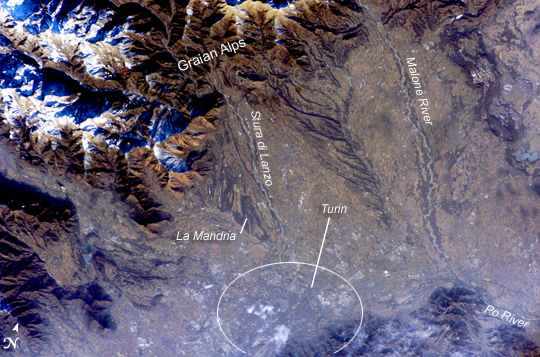
Turin, ItalyLocated in the Piedmont (Piemonte in Italian) region of northwestern Italy, the city of Turin (Torino) is an important industrial and cultural center hosting the Twentieth Olympic Winter Games. The Games will draw 2,600 athletes from 82 nations to compete in such traditional winter sports as skating, skiing, biathlon, bobsleigh, curling, ice hockey, and luge. Venues for the Games include several locations within downtown Turin and the nearby Alps to the west. The first Olympic Winter Games competition was held in Chamonix, France in 1924 with 258 athletes representing 16 nations.
The image illustrates the striking landscape surrounding the city, with the snow-capped Alps visible to the west and north. The city is located on the northern banks of the famous Po River. Two of the Po’s major tributaries are visible in this image, Stura di Lanzo and the Malone River. The built area of Turin appears dark grayish brown with large building complexes indicated by white roofs (bottom image center). La Mandria Regional Park, located along the southwest bank of Stura di Lanzo, is a nature and historical preserve approximately 10 km (6 miles) to the northwest of the city center. Decreasing image contrast over Turin is the result of atmospheric pollution commonly observed in the Po River valley.
Download Packaged File.
This option downloads the following items, packaged into a single file, if they are available:
- Browse image
- Cataloged information with captions
- Camera file
- Sound file
Server: 2 |
This service is provided by the International Space Station program. |
Recommended Citation: |
||

