| Home >> | Advanced Search >> |
 |
|
Astronaut Photography of Earth - Display Record
ISS008-E-15493

Low-resolution Browse Image
(Most browse images are not color adjusted.)Images
Conditions for Use of Images >>Image Transformation Tutorial >> Saving, Color Adjusting, and Printing Images >>
Images to View on Your Computer Now
| File Name | File Size (bytes) | Width | Height | Annotated | Cropped | Purpose | Comments | |
|---|---|---|---|---|---|---|---|---|
| View | ISS008-E-15493.JPG | 46443 | 540 | 270 | Yes | NASA's Earth Observatory web site | ||
| View | ISS008-E-15493.JPG | 90833 | 639 | 435 | No | No | ||
| View | ISS008-E-15493.JPG | 363278 | 1000 | 663 | No | NASA's Earth Observatory web site | color adjusted | |
| View | ISS008-E-15493_2.JPG | 513386 | 661 | 1000 | No | Yes | NASA's Earth Observatory web site | Color adjusted |
Large Images to Request for Downloading
| File Name | File Size (bytes) | Width | Height | Annotated | Cropped | Purpose | Comments | |
|---|---|---|---|---|---|---|---|---|
| Request | ISS008-E-15493.JPG | 1238438 | 3032 | 2064 | No | No | ||
| Request | ISS008-E-15493.JPG | 5387357 | 2004 | 3032 | No | No | NASA's Earth Observatory web site | Color adjusted |
Download a Keyhole Markup Language (KML) file for use in Google Earth.
Electronic Image Data
Camera Files >> No sound file available.Identification
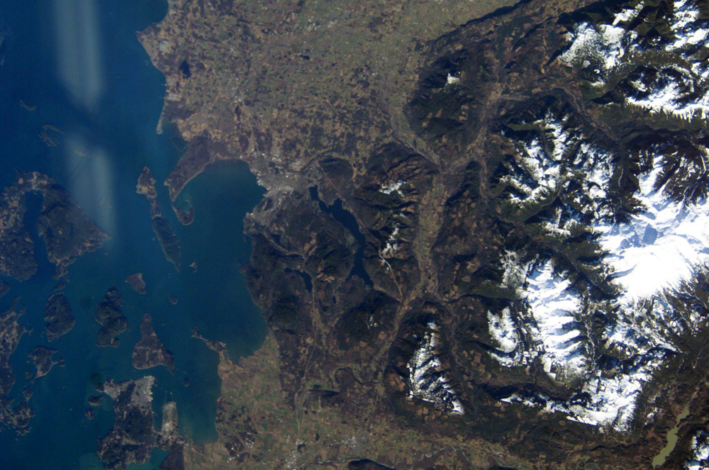
Mission: ISS008 Roll: E Frame: 15493 Mission ID on the Film or image: ISS008Country or Geographic Name: USA-WASHINGTON
Features: BELLINGHAM, FRASER RIVER VALLEY, MTS.
Center Point Latitude: 48.5 Center Point Longitude: -122.0 (Negative numbers indicate south for latitude and west for longitude)
Stereo: (Yes indicates there is an adjacent picture of the same area)
ONC Map ID: JNC Map ID:
Camera
Camera Tilt: 51Camera Focal Length: 80mm
Camera: E4: Kodak DCS760C Electronic Still Camera
Film: 3060E : 3060 x 2036 pixel CCD, RGBG array.
Quality
Film Exposure:Percentage of Cloud Cover: 10 (0-10)
Nadir
Date: 20040212 (YYYYMMDD)GMT Time: 190231 (HHMMSS)Nadir Point Latitude: 49.1, Longitude: -118.1 (Negative numbers indicate south for latitude and west for longitude)
Nadir to Photo Center Direction: West
Sun Azimuth: 163 (Clockwise angle in degrees from north to the sun measured at the nadir point)
Spacecraft Altitude: 194 nautical miles (359 km)
Sun Elevation Angle: 26 (Angle in degrees between the horizon and the sun, measured at the nadir point)
Orbit Number: 1864
Captions
Mount Baker, Washington—a Hazardous Beauty:The Cascade Range is an arc of volcanoes that extends from southwestern British Columbia to northern California. One of the six major composite volcanoes (formed by alternating layers of extruded lava and compacted ash) is Mount Baker in northern Washington. Close to the Canadian border, Mount Baker is about 85 miles north-northeast of Seattle and 65 miles southeast of Vancouver, British Columbia. This beautiful, snow-capped peak dominates the skyline from Bellingham, Washington to Vancouver, and offers multiple recreational opportunities to visitors and locals alike.
The life-threatening and destructive hazards of composite volcanoes include their tephra (ejected ash and rocks), lava flows, lahars (a mudslide composed of volcanic ash and debris saturated with water, often from glacial melt), and debris avalanches. Modern Mount Baker itself is a relatively young volcano (10,000-30,000 years old), but no eruptions have been observed since the mid-1800s. However, a steam plume is often observed from Sherman Crater at the summit (10,778 feet), occasionally alarming local residents. A marked increase in plume activity accompanied by unusual snowmelt led to the temporary closure of Baker Lake by the National Park Service in 1975.
This two photograph was taken from the International Space Station. ISS008-E-15491 provides details of the rough terrain near the summit and on the upper flanks. This view provides a regional picture of Mount Baker, showing its proximity to Bellingham.
Download Packaged File.
This option downloads the following items, packaged into a single file, if they are available:
- Browse image
- Cataloged information with captions
- Camera file
- Sound file
Server: 2 |
This service is provided by the International Space Station program. |
Recommended Citation: |
||

