| Home >> | Advanced Search >> |
 |
|
Astronaut Photography of Earth - Display Record
ISS007-E-15177

Low-resolution Browse Image
(Most browse images are not color adjusted.)Images
Conditions for Use of Images >>Image Transformation Tutorial >> Saving, Color Adjusting, and Printing Images >>
Images to View on Your Computer Now
| File Name | File Size (bytes) | Width | Height | Annotated | Cropped | Purpose | Comments | |
|---|---|---|---|---|---|---|---|---|
| View | ISS007-E-15177.JPG | 85729 | 540 | 540 | Yes | Yes | NASA's Earth Observatory web site | |
| View | ISS007-E-15177.JPG | 85729 | 540 | 540 | Yes | Yes | NASA's Earth Observatory web site | |
| View | ISS007-E-15177.JPG | 89503 | 639 | 435 | No | No | ||
| View | ISS007-E-15177.JPG | 94149 | 435 | 540 | Photographic Highlights | (resized 540 px images) | ||
| View | ISS007-E-15177_2.JPG | 170840 | 619 | 768 | Photographic Highlights | (actual files used) | ||
| View | ISS007-E-15177.JPG | 1631259 | 1000 | 1236 | No | Yes | NASA's Earth Observatory web site | Color adjusted |
Large Images to Request for Downloading
| File Name | File Size (bytes) | Width | Height | Annotated | Cropped | Purpose | Comments | |
|---|---|---|---|---|---|---|---|---|
| Request | ISS007-E-15177.JPG | 1211223 | 3032 | 2064 | No | No | ||
| Request | ISS007-E-15177_2.JPG | 6344867 | 6144 | 4068 | No | No | Presentation | Earth Sciences Results Briefing/Ed Lu |
| Request | ISS007-E-15177.JPG | 6732141 | 3032 | 2064 | No | No | Earth From Space collection | Color adjusted |
Download a Keyhole Markup Language (KML) file for use in Google Earth.
Electronic Image Data
Camera Files >> No sound file available.Identification
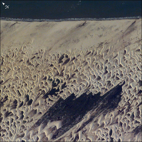
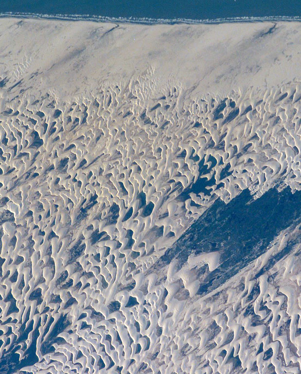
Mission: ISS007 Roll: E Frame: 15177 Mission ID on the Film or image: ISS007Country or Geographic Name: BRAZIL
Features: LENCOIS MARANHENSES, DUNES
Center Point Latitude: -2.5 Center Point Longitude: -43.0 (Negative numbers indicate south for latitude and west for longitude)
Stereo: (Yes indicates there is an adjacent picture of the same area)
ONC Map ID: JNC Map ID:
Camera
Camera Tilt: 22Camera Focal Length: 400mm
Camera: E4: Kodak DCS760C Electronic Still Camera
Film: 3060E : 3060 x 2036 pixel CCD, RGBG array.
Quality
Film Exposure:Percentage of Cloud Cover: 10 (0-10)
Nadir
Date: 20030921 (YYYYMMDD)GMT Time: 194325 (HHMMSS)Nadir Point Latitude: -1.7, Longitude: -44.1 (Negative numbers indicate south for latitude and west for longitude)
Nadir to Photo Center Direction: Southeast
Sun Azimuth: 271 (Clockwise angle in degrees from north to the sun measured at the nadir point)
Spacecraft Altitude: 205 nautical miles (380 km)
Sun Elevation Angle: 16 (Angle in degrees between the horizon and the sun, measured at the nadir point)
Orbit Number: 3609
Captions
The area shown here (10 km across) is a small part of the dune field which is now protected as the Lençóis Maranhenses National Park, on Brazil’s north coast, about 700 km east of the Amazon River mouth. Persistent winds blow off the equatorial Atlantic Ocean onto Brazil from the east, driving white sand inland from the 100 km stretch of coast (upper margin of the image), to form a large field of dunes. The strongly regular pattern of these dunes is a common characteristic of dune fields. The basic shape of each sand mass, repeated throughout the view, is a crescent-shaped dune. In an area with a rich supply of sand such as coastal Brazil, individual crescents coalesce to form entire chains many miles long. The wind strength and supply of sand are sufficient to keep the dunes active, and thus free of vegetation, despite 1500 mm (60 inches) of rainfall annually. The dark areas between the white dunes are fresh water ponds that draw fisherman to this newly established park.The characteristic regularity of the dune landscape can be detected downwind (west) for more than 100 km, beyond the present dune field. Now covered by dense forest, the greater extent of this dune field indicates that climates have been substantially drier at the Equator in the recent geological past.
Download Packaged File.
This option downloads the following items, packaged into a single file, if they are available:
- Browse image
- Cataloged information with captions
- Camera file
- Sound file
Server: 2 |
This service is provided by the International Space Station program. |
Recommended Citation: |
||

