| Home >> | Advanced Search >> |
 |
|
Astronaut Photography of Earth - Display Record
ISS012-E-15050
Low-resolution Browse Image
(Most browse images are not color adjusted.)Images
Conditions for Use of Images >>Image Transformation Tutorial >> Saving, Color Adjusting, and Printing Images >>
Images to View on Your Computer Now
| File Name | File Size (bytes) | Width | Height | Annotated | Cropped | Purpose | Comments | |
|---|---|---|---|---|---|---|---|---|
| View | ISS012-E-15050.JPG | 73453 | 639 | 435 | No | No | ||
| View | ISS012-E-15050.JPG | 397086 | 540 | 681 | Yes | Yes | NASA's Earth Observatory web site |
Large Images to Request for Downloading
| File Name | File Size (bytes) | Width | Height | Annotated | Cropped | Purpose | Comments | |
|---|---|---|---|---|---|---|---|---|
| Request | ISS012-E-15050.JPG | 1036393 | 3032 | 2064 | No | No | ||
| Request | ISS012-E-15050.JPG | 1177765 | 1000 | 1261 | No | Yes | NASA's Earth Observatory web site |
Download a Keyhole Markup Language (KML) file for use in Google Earth.
Electronic Image Data
Camera Files >> No sound file available.Identification
Mission: ISS012 Roll: E Frame: 15050 Mission ID on the Film or image: ISS012Country or Geographic Name: USA-OHIO
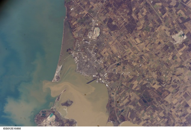
Features: SANDUSKY, BAY, SED. PLUMES
Center Point Latitude: 41.4 Center Point Longitude: -82.7 (Negative numbers indicate south for latitude and west for longitude)
Stereo: (Yes indicates there is an adjacent picture of the same area)
ONC Map ID: JNC Map ID:
Camera
Camera Tilt: 31Camera Focal Length: 400mm
Camera: E4: Kodak DCS760C Electronic Still Camera
Film: 3060E : 3060 x 2036 pixel CCD, RGBG array.
Quality
Film Exposure:Percentage of Cloud Cover: 10 (0-10)
Nadir
Date: 20060112 (YYYYMMDD)GMT Time: 183959 (HHMMSS)Nadir Point Latitude: 41.8, Longitude: -80.9 (Negative numbers indicate south for latitude and west for longitude)
Nadir to Photo Center Direction: West
Sun Azimuth: 197 (Clockwise angle in degrees from north to the sun measured at the nadir point)
Spacecraft Altitude: 184 nautical miles (341 km)
Sun Elevation Angle: 25 (Angle in degrees between the horizon and the sun, measured at the nadir point)
Orbit Number: 867
Captions
Sandusky, OhioMuddy brown water fills Sandusky Bay, just south of Lake Erie in this astronaut photograph. The small city of Sandusky occupies the southeastern shore of the bay. Highway 2 can be seen arcing around the south side of the city. Ferries connect Sandusky to Pelee Island (not visible) in the middle of the lake. In earlier days, Sandusky Bay was known as one of the port sites best protected from rough waters in the Great Lakes.
The most striking aspect of this image is the flow of the brown water in and out of the mouth of the bay. Slight movement of lake surface water, driven mainly by wind, causes a small ebb and flow of bay water. Sediment-charged water is derived from agricultural fields along the Sandusky River upstream. Mud plumes in Lake Erie originate from prior pulses of muddy water from the bay. When this image was taken, some clear, lake water (blue-green strip) appeared to be flowing into the bay.
Sandusky lies midway between Toledo and Cleveland, both about an hour’s drive away. Sandusky has a diverse economic base in engineering and chemical plants, as well as boasting one of the most popular vacation destinations in the United States, drawing millions of visitors each year to its very large amusement park, located on the eastern spit between Sandusky Bay and Lake Erie. NASA Glenn Research Center - Plum Brook Station also appears in this image, in the lower right corner.
Download Packaged File.
This option downloads the following items, packaged into a single file, if they are available:
- Browse image
- Cataloged information with captions
- Camera file
- Sound file
Server: 2 |
This service is provided by the International Space Station program. |
Recommended Citation: |
||

