| Home >> | Advanced Search >> |
 |
|
Astronaut Photography of Earth - Display Record
ISS013-E-14843
Low-resolution Browse Image
(Most browse images are not color adjusted.)Images
Conditions for Use of Images >>Image Transformation Tutorial >> Saving, Color Adjusting, and Printing Images >>
Images to View on Your Computer Now
| File Name | File Size (bytes) | Width | Height | Annotated | Cropped | Purpose | Comments | |
|---|---|---|---|---|---|---|---|---|
| View | ISS013-E-14843.JPG | 67806 | 639 | 435 | No | No | ||
| View | ISS013-E-14843.JPG | 284656 | 540 | 377 | Yes | Yes | NASA's Earth Observatory web site |
Large Images to Request for Downloading
| File Name | File Size (bytes) | Width | Height | Annotated | Cropped | Purpose | Comments | |
|---|---|---|---|---|---|---|---|---|
| Request | ISS013-E-14843.JPG | 817341 | 1000 | 699 | No | Yes | NASA's Earth Observatory web site | |
| Request | ISS013-E-14843.JPG | 1094102 | 3032 | 2064 | No | No |
Download a Keyhole Markup Language (KML) file for use in Google Earth.
Electronic Image Data
Camera Files >> No sound file available.Identification
Mission: ISS013 Roll: E Frame: 14843 Mission ID on the Film or image: ISS013Country or Geographic Name: USA-MICHIGAN
Features: ROGERS CITY,LIMESTONE QUARRY
Center Point Latitude: 45.4 Center Point Longitude: -83.8 (Negative numbers indicate south for latitude and west for longitude)
Stereo: (Yes indicates there is an adjacent picture of the same area)
ONC Map ID: JNC Map ID:
Camera
Camera Tilt: 37Camera Focal Length: 800mm
Camera: E4: Kodak DCS760C Electronic Still Camera
Film: 3060E : 3060 x 2036 pixel CCD, RGBG array.
Quality
Film Exposure:Percentage of Cloud Cover: 10 (0-10)
Nadir
Date: 20060506 (YYYYMMDD)GMT Time: 211724 (HHMMSS)Nadir Point Latitude: 47.6, Longitude: -84.4 (Negative numbers indicate south for latitude and west for longitude)
Nadir to Photo Center Direction: South
Sun Azimuth: 256 (Clockwise angle in degrees from north to the sun measured at the nadir point)
Spacecraft Altitude: 183 nautical miles (339 km)
Sun Elevation Angle: 35 (Angle in degrees between the horizon and the sun, measured at the nadir point)
Orbit Number: 2665
Captions
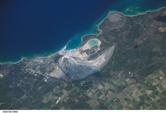
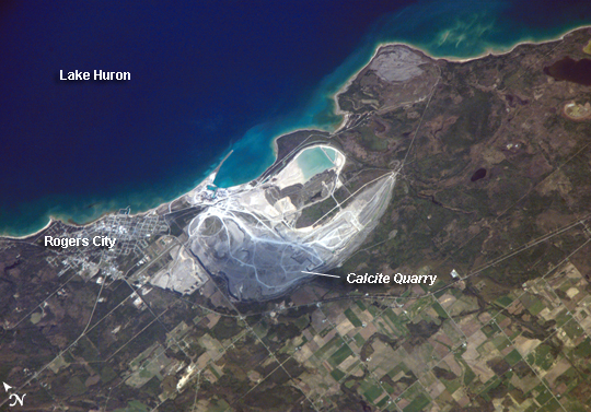
Calcite Quarry, MichiganWhile the Great Lakes region of North America is well known for its importance to shipping between the United States, Canada, and the Atlantic Ocean, it is also the location of an impressive structure in the continent’s bedrock: the Michigan Basin. Formed during the Paleozoic Era (approximately 540-250 million years ago) the Basin looks much like a large bullseye defined by the arrangement of exposed rock layers that all tilt inwards, forming a huge bowl-shaped structure. While this “bowl” is not readily apparent from the ground, detailed mapping of the rock units on a regional scale revealed the structure to geologists. The outer layers of the Basin include thick deposits of carbonates—rocks containing carbon and oxygen, such as limestone—deposited over millions of years when a shallow sea covered the region.
These carbonate rocks are mined throughout the Great Lakes region using large open-pit mines. The largest carbonate mine in the world, Calcite Quarry, appears in this astronaut photograph. The mine has been active for over 85 years. The worked area (grey region in image center) measures approximately 7 kilometers long by 4 kilometers wide, and it is crossed by several access roads (white). The rocks are processed to create crushed aggregate, building stone, soil enhancers, lime, additives to steel, and a host of other products. Calcite Quarry ships between 7 and 10.5 million tons of material each year, thanks to the quarry’s location on the shores of Lake Huron. Nearby Rogers City was once a typical mining company town, but over time it has expanded its economic base as a summer retreat for sailing and tourism.
Download Packaged File.
This option downloads the following items, packaged into a single file, if they are available:
- Browse image
- Cataloged information with captions
- Camera file
- Sound file
Server: 2 |
This service is provided by the International Space Station program. |
Recommended Citation: |
||

