| Home >> | Advanced Search >> |
 |
|
Astronaut Photography of Earth - Display Record
ISS010-E-14618

Low-resolution Browse Image
(Most browse images are not color adjusted.)Images
Conditions for Use of Images >>Image Transformation Tutorial >> Saving, Color Adjusting, and Printing Images >>
Images to View on Your Computer Now
| File Name | File Size (bytes) | Width | Height | Annotated | Cropped | Purpose | Comments | |
|---|---|---|---|---|---|---|---|---|
| View | ISS010-E-14618.JPG | 111549 | 639 | 435 | No | No | ||
| View | ISS010-E-14618.JPG | 310858 | 540 | 356 | Yes | Yes | NASA's Earth Observatory web site |
Large Images to Request for Downloading
| File Name | File Size (bytes) | Width | Height | Annotated | Cropped | Purpose | Comments | |
|---|---|---|---|---|---|---|---|---|
| Request | ISS010-E-14618.JPG | 876550 | 1000 | 660 | No | Yes | NASA's Earth Observatory web site | |
| Request | ISS010-E-14618.JPG | 1388562 | 3032 | 2064 | No | No |
Download a Keyhole Markup Language (KML) file for use in Google Earth.
Electronic Image Data
Camera Files >> No sound file available.Identification
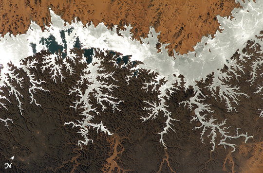
Mission: ISS010 Roll: E Frame: 14618 Mission ID on the Film or image: ISS010Country or Geographic Name: EGYPT
Features: LAKE NASSER,SUNGLINT
Center Point Latitude: 22.5 Center Point Longitude: 32.5 (Negative numbers indicate south for latitude and west for longitude)
Stereo: (Yes indicates there is an adjacent picture of the same area)
ONC Map ID: JNC Map ID:
Camera
Camera Tilt: 54Camera Focal Length: 400mm
Camera: E4: Kodak DCS760C Electronic Still Camera
Film: 3060E : 3060 x 2036 pixel CCD, RGBG array.
Quality
Film Exposure:Percentage of Cloud Cover: 10 (0-10)
Nadir
Date: 20050123 (YYYYMMDD)GMT Time: 095135 (HHMMSS)Nadir Point Latitude: 26.7, Longitude: 33.8 (Negative numbers indicate south for latitude and west for longitude)
Nadir to Photo Center Direction: South
Sun Azimuth: 178 (Clockwise angle in degrees from north to the sun measured at the nadir point)
Spacecraft Altitude: 188 nautical miles (348 km)
Sun Elevation Angle: 44 (Angle in degrees between the horizon and the sun, measured at the nadir point)
Orbit Number: 3292
Captions
ISS010-E-14618 (23 January 2005) --- Egypt's Lake Nasser, centered roughly at 22.64 degrees north latitude and 32.45 degrees east longitude, was captured with an electronic still camera by the Expedition 10 crew onboard the International Space Station. Sunglint on the lake makes it more easily visible.Download Packaged File.
This option downloads the following items, packaged into a single file, if they are available:
- Browse image
- Cataloged information with captions
- Camera file
- Sound file
Server: 2 |
This service is provided by the International Space Station program. |
Recommended Citation: |
||

