| Home >> | Advanced Search >> |
 |
|
Astronaut Photography of Earth - Display Record
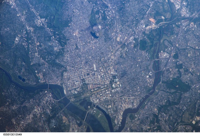
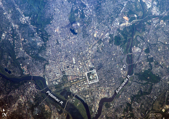
ISS013-E-13549
Low-resolution Browse Image
(Most browse images are not color adjusted.)Images
Conditions for Use of Images >>Image Transformation Tutorial >> Saving, Color Adjusting, and Printing Images >>
Images to View on Your Computer Now
| File Name | File Size (bytes) | Width | Height | Annotated | Cropped | Purpose | Comments | |
|---|---|---|---|---|---|---|---|---|
| View | ISS013-E-13549.JPG | 123066 | 639 | 435 | No | No | ||
| View | ISS013-E-13549.JPG | 387139 | 540 | 381 | Yes | Yes | NASA's Earth Observatory web site |
Large Images to Request for Downloading
| File Name | File Size (bytes) | Width | Height | Annotated | Cropped | Purpose | Comments | |
|---|---|---|---|---|---|---|---|---|
| Request | ISS013-E-13549.JPG | 1166721 | 1000 | 706 | No | Yes | NASA's Earth Observatory web site | |
| Request | ISS013-E-13549.JPG | 1692104 | 3032 | 2064 | No | No |
Download a Keyhole Markup Language (KML) file for use in Google Earth.
Electronic Image Data
Camera Files >> No sound file available.Identification
Mission: ISS013 Roll: E Frame: 13549 Mission ID on the Film or image: ISS013Country or Geographic Name: USA-DC
Features: WASHINGTON METRO AREA
Center Point Latitude: 38.9 Center Point Longitude: -77.0 (Negative numbers indicate south for latitude and west for longitude)
Stereo: (Yes indicates there is an adjacent picture of the same area)
ONC Map ID: JNC Map ID:
Camera
Camera Tilt: 41Camera Focal Length: 800mm
Camera: E4: Kodak DCS760C Electronic Still Camera
Film: 3060E : 3060 x 2036 pixel CCD, RGBG array.
Quality
Film Exposure:Percentage of Cloud Cover: 10 (0-10)
Nadir
Date: 20060502 (YYYYMMDD)GMT Time: 211823 (HHMMSS)Nadir Point Latitude: 39.3, Longitude: -79.6 (Negative numbers indicate south for latitude and west for longitude)
Nadir to Photo Center Direction: East
Sun Azimuth: 264 (Clockwise angle in degrees from north to the sun measured at the nadir point)
Spacecraft Altitude: 184 nautical miles (341 km)
Sun Elevation Angle: 32 (Angle in degrees between the horizon and the sun, measured at the nadir point)
Orbit Number: 2602
Captions
Washington, D.C.George Washington not only served as the namesake for the capital city of the United States, he also chose its location, perhaps envisioning the transportation possibilities that the Potomac River flowing past the site would provide. Early on, the city saw conflict; in the War of 1812, British forces invaded and burned several public buildings. The Civil War marked the beginning of the city’s transformation from a provincial town to a world center of culture, history, and political energy during the 20th century. According to the Census Bureau, the District of Columbia, which comprises the city of Washington, supported a population of more than half a million inhabitants in 2003.
This picture was taken as the International Space Station passed over the western border of Maryland and West Virginia. The resolution and spatial coverage of this image are similar to the 15-meter-per-pixel data obtained by sensors onboard the Landsat 7 and Terra satellites. Recognizable in this image are the Capitol Building, the Washington Monument (and its shadow), and the Lincoln Memorial, along the northeast bank of the Potomac River.
Download Packaged File.
This option downloads the following items, packaged into a single file, if they are available:
- Browse image
- Cataloged information with captions
- Camera file
- Sound file
Server: 2 |
This service is provided by the International Space Station program. |
Recommended Citation: |
||

