| Home >> | Advanced Search >> |
 |
|
Astronaut Photography of Earth - Display Record
ISS010-E-13393

Low-resolution Browse Image
(Most browse images are not color adjusted.)Images
Conditions for Use of Images >>Image Transformation Tutorial >> Saving, Color Adjusting, and Printing Images >>
Images to View on Your Computer Now
| File Name | File Size (bytes) | Width | Height | Annotated | Cropped | Purpose | Comments | |
|---|---|---|---|---|---|---|---|---|
| View | ISS010-E-13393.JPG | 110197 | 639 | 435 | No | No | ||
| View | ISS010-E-13393.JPG | 274240 | 540 | 357 | Yes | Yes | Earth From Space collection | |
| View | ISS010-E-13393.JPG | 803541 | 1000 | 661 | No | Yes | NASA's Earth Observatory web site |
Large Images to Request for Downloading
| File Name | File Size (bytes) | Width | Height | Annotated | Cropped | Purpose | Comments | |
|---|---|---|---|---|---|---|---|---|
| Request | ISS010-E-13393.JPG | 1335839 | 3032 | 2064 | No | No |
Download a Keyhole Markup Language (KML) file for use in Google Earth.
Electronic Image Data
Camera Files >> No sound file available.Identification
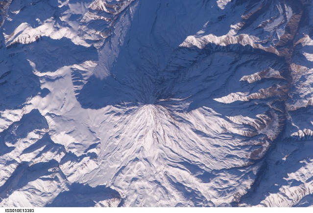
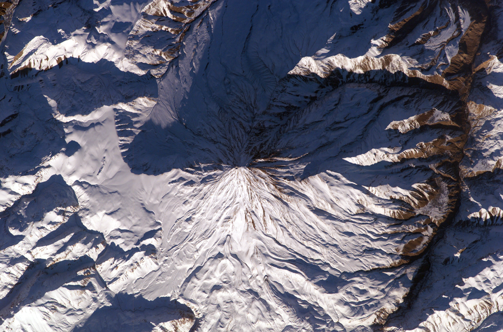
Mission: ISS010 Roll: E Frame: 13393 Mission ID on the Film or image: ISS010Country or Geographic Name: IRAN
Features: DAMAVAND VOLCANO, LAVA FLOWS
Center Point Latitude: 36.0 Center Point Longitude: 52.1 (Negative numbers indicate south for latitude and west for longitude)
Stereo: (Yes indicates there is an adjacent picture of the same area)
ONC Map ID: JNC Map ID:
Camera
Camera Tilt: 34Camera Focal Length: 400mm
Camera: E4: Kodak DCS760C Electronic Still Camera
Film: 3060E : 3060 x 2036 pixel CCD, RGBG array.
Quality
Film Exposure:Percentage of Cloud Cover: 10 (0-10)
Nadir
Date: 20050115 (YYYYMMDD)GMT Time: 122941 (HHMMSS)Nadir Point Latitude: 36.2, Longitude: 54.2 (Negative numbers indicate south for latitude and west for longitude)
Nadir to Photo Center Direction: West
Sun Azimuth: 235 (Clockwise angle in degrees from north to the sun measured at the nadir point)
Spacecraft Altitude: 188 nautical miles (348 km)
Sun Elevation Angle: 10 (Angle in degrees between the horizon and the sun, measured at the nadir point)
Orbit Number: 3168
Captions
Mt. Damavand, IranLocated approximately 50 kilometers northeast of Tehran, Mt. Damavand is an impressive stratovolcano that reaches 5,670 meters (18,598 feet) in elevation. Part of the Alborz Mountain Range that borders the Caspian Sea to the north, Damavand is a young volcano that has formed mostly during the Holocene Epoch (over approximately the last 10,000 years). The western flank of the volcano includes solidified lava flows with flow levees—“walls” formed as the side edges of flowing lava cooled rapidly, forming a chute that channeled the hotter, interior lava. Two such flows with well-defined levees are highlighted by snow on the mountainside.
Damavand is the highest peak in Iran and the highest volcano in the Middle East. The mountain and its surrounding areas are popular hiking, climbing, and skiing destinations. While no historic eruptions of the volcano are recorded, hot springs on the flanks of the volcano and fumaroles (steam vents) in the summit crater suggest that a hot or cooling magma body is still present beneath the volcano. This continuing activity, while minor, indicates a dormant rather than extinct volcano.
Download Packaged File.
This option downloads the following items, packaged into a single file, if they are available:
- Browse image
- Cataloged information with captions
- Camera file
- Sound file
Server: 2 |
This service is provided by the International Space Station program. |
Recommended Citation: |
||

