| Home >> | Advanced Search >> |
 |
|
Astronaut Photography of Earth - Display Record
ISS009-E-13366

Low-resolution Browse Image
(Most browse images are not color adjusted.)Images
Conditions for Use of Images >>Image Transformation Tutorial >> Saving, Color Adjusting, and Printing Images >>
Images to View on Your Computer Now
| File Name | File Size (bytes) | Width | Height | Annotated | Cropped | Purpose | Comments | |
|---|---|---|---|---|---|---|---|---|
| View | ISS009-E-13366.JPG | 71549 | 639 | 435 | No | No | ||
| View | ISS009-E-13366.JPG | 87653 | 540 | 553 | NASA's Earth Observatory web site | |||
| View | ISS009-E-13366.JPG | 448439 | 1000 | 1093 | No | Yes |
Large Images to Request for Downloading
| File Name | File Size (bytes) | Width | Height | Annotated | Cropped | Purpose | Comments | |
|---|---|---|---|---|---|---|---|---|
| Request | ISS009-E-13366.JPG | 890081 | 3032 | 2064 | No | No |
Download a Keyhole Markup Language (KML) file for use in Google Earth.
Electronic Image Data
Camera Files >> No sound file available.Identification
Mission: ISS009 Roll: E Frame: 13366 Mission ID on the Film or image: ISS009Country or Geographic Name: TANZANIA
Features: MOUNT KILIMANJARO, GLACIERS
Center Point Latitude: -3.1 Center Point Longitude: 37.3 (Negative numbers indicate south for latitude and west for longitude)
Stereo: (Yes indicates there is an adjacent picture of the same area)
ONC Map ID: JNC Map ID:
Camera
Camera Tilt: 15Camera Focal Length: 800mm
Camera: E4: Kodak DCS760C Electronic Still Camera
Film: 3060E : 3060 x 2036 pixel CCD, RGBG array.
Quality
Film Exposure:Percentage of Cloud Cover: 25 (11-25)
Nadir
Date: 20040628 (YYYYMMDD)GMT Time: 090411 (HHMMSS)Nadir Point Latitude: -2.8, Longitude: 38.1 (Negative numbers indicate south for latitude and west for longitude)
Nadir to Photo Center Direction: West
Sun Azimuth: 14 (Clockwise angle in degrees from north to the sun measured at the nadir point)
Spacecraft Altitude: 196 nautical miles (363 km)
Sun Elevation Angle: 63 (Angle in degrees between the horizon and the sun, measured at the nadir point)
Orbit Number: 7
Captions
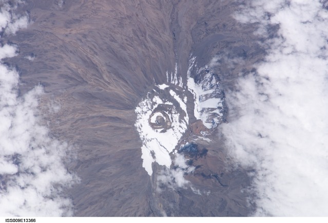
Mount Kilimanjaro Closeup:Mount Kilimanjaro is a dormant stratovolcano and the highest mountain in Africa. Kibo Summit (5,893 m) at the top of Kilimanjaro is one of the few peaks in Africa to retain glaciers. A comparison image (ISS006-E-45499) is a high oblique photograph taken from the International Space Station in early April 2003. That photograph provides a 3-dimensional perspective on the positions of the glaciers on the upper northwestern and southern flanks of the mountain. This photograph, ISS009-E-13366, taken from the International Space Station in late June 2004, shows large glacier fields (blue-white, with defined edges) on the northwestern and southern slopes of the peak. In this scene, a light layer of snow brightens the dark brown terrain around the glaciers.
Scientists use ice cores, an automated weather station, computer modeling, and images like these as tools to learn about the past and present activity of Kilimanjaro’s receding glaciers. One atmospheric scientist at the University of Wisconsin-Madison found clues that link reduced cloud cover to post-1880 decreased water levels in East African lakes. Lake evaporation indicates a decrease in both precipitation and cloudiness around Kilimanjaro. These two images illustrate the changes over time in snow cover at the summit as well as the current extent of the glaciers themselves. Light brown outwash channels from the northwestern flank icefield are particularly evident in the oblique photograph (top). While clear conditions over Kilimanjaro allow for the collection of spectacular images like these, the lack of cloud cover may be one cause for the glaciers’ retreat. The increased sunlight facilitates faster evaporation and less precipitation—thus, the land surface absorbs more incoming sunlight and, as it warms, the ice and snow melts at an accelerated pace.
Most scientists agree that the glaciers of Mt. Kilimanjaro will be gone by the year 2020, but there is less agreement as to why they are now receding. Climatologists are now studying current weather trends, environmental changes from the late 1800s, and historical records of the mountain climate compared with longer-term climate records at lower elevations. A correct interpretation of the ice core data may help provide an explanation for this glacial recession. The loss of Kilimanjaro’s permanent ice fields will have both climatological and hydrological implications for local populations who depend on access to melt water from the ice fields as a source of fresh water during dry seasons and monsoon failures.
Additional images of Mt. Kilimanjaro:
Kilimanjaro (Landsat 7)
Mount Kilimanjaro, Tanzania (SRTM)
Melting Snows of Kilimanjaro (Landsat 5 & 7)
Kilimanjaro-The Shining Mountain (Space Shuttle STS 38)
Mt. Kilimanjaro’s Receding Glaciers (Space Shuttle STS 97)
Download Packaged File.
This option downloads the following items, packaged into a single file, if they are available:
- Browse image
- Cataloged information with captions
- Camera file
- Sound file
Server: 2 |
This service is provided by the International Space Station program. |
Recommended Citation: |
||

