| Home >> | Advanced Search >> |
 |
|
Astronaut Photography of Earth - Display Record
ISS007-E-13090

Low-resolution Browse Image
(Most browse images are not color adjusted.)Images
Conditions for Use of Images >>Image Transformation Tutorial >> Saving, Color Adjusting, and Printing Images >>
Images to View on Your Computer Now
| File Name | File Size (bytes) | Width | Height | Annotated | Cropped | Purpose | Comments | |
|---|---|---|---|---|---|---|---|---|
| View | ISS007-E-13090.JPG | 68242 | 639 | 435 | No | No | ||
| View | ISS007-E-13090.JPG | 92749 | 376 | 540 | Photographic Highlights | (resized 540 px images) | ||
| View | ISS007-E-13090.JPG | 118536 | 540 | 540 | Yes | Yes | NASA's Earth Observatory web site | |
| View | ISS007-E-13090.JPG | 118536 | 540 | 540 | Yes | Yes | NASA's Earth Observatory web site | |
| View | ISS007-E-13090_2.JPG | 195011 | 535 | 768 | Photographic Highlights | (actual files used) | ||
| View | ISS007-E-13090.JPG | 1991839 | 1000 | 1428 | No | Yes | NASA's Earth Observatory web site | color corrected |
Large Images to Request for Downloading
| File Name | File Size (bytes) | Width | Height | Annotated | Cropped | Purpose | Comments | |
|---|---|---|---|---|---|---|---|---|
| Request | ISS007-E-13090.JPG | 1116348 | 3032 | 2064 | No | No | ||
| Request | ISS007-E-13090_2.JPG | 6849077 | 6144 | 4068 | No | No | Presentation | Earth Sciences Results Briefing/Ed Lu |
| Request | ISS007-E-13090.JPG | 7151379 | 3032 | 2064 | No | No | NASA's Earth Observatory web site | color corrected |
Download a Keyhole Markup Language (KML) file for use in Google Earth.
Electronic Image Data
Camera Files >> Audio file >>Identification
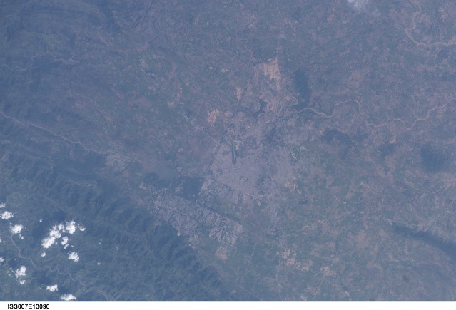
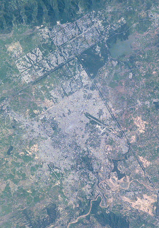
Mission: ISS007 Roll: E Frame: 13090 Mission ID on the Film or image: ISS007Country or Geographic Name: PAKISTAN
Features: RAWALPINDI, ISLAMABAD, AGRICULTURE
Center Point Latitude: 33.5 Center Point Longitude: 73.0 (Negative numbers indicate south for latitude and west for longitude)
Stereo: (Yes indicates there is an adjacent picture of the same area)
ONC Map ID: JNC Map ID:
Camera
Camera Tilt: 24Camera Focal Length: 180mm
Camera: E4: Kodak DCS760C Electronic Still Camera
Film: 3060E : 3060 x 2036 pixel CCD, RGBG array.
Quality
Film Exposure:Percentage of Cloud Cover: 10 (0-10)
Nadir
Date: 20030821 (YYYYMMDD)GMT Time: 102502 (HHMMSS)Nadir Point Latitude: 33.7, Longitude: 74.5 (Negative numbers indicate south for latitude and west for longitude)
Nadir to Photo Center Direction: West
Sun Azimuth: 257 (Clockwise angle in degrees from north to the sun measured at the nadir point)
Spacecraft Altitude: 202 nautical miles (374 km)
Sun Elevation Angle: 40 (Angle in degrees between the horizon and the sun, measured at the nadir point)
Orbit Number: 3119
Captions
Islamabad and Rawalpindi, Pakistan:Two capital cities in Pakistan lie next to one another but display land use patterns that are entirely different. Islamabad, with a population of 901,000 (ca. 1998) boasts a master-planned rectangular street pattern nestled against the Margala Hills (top left). The larger Rawalpindi (population 1,406,214 in 1998) lies to the south on the Soan River.
Islamabad has grown rapidly since construction began in 1961. It was created as a new administrative district in Pakistan to be the home of government, the supreme court, and the diplomatic corps. The great white building of the Faisal Mosque appears on the northern margin of the city. By contrast with orthogonal Islamabad, Rawalpindi displays the radial land transportation pattern of many cities with a river flowing through the city center. City blocks are small and growth less controlled than in its newer neighbor. Airports can be seen to the east and south.
Rawalpindi was an important British military center from the mid-1800s during colonial times, and became the interim capital for a decade (1959–69) once the decision was made to move the capital from Karachi inland to be closer to disputed Kashmir and neighboring Muslim countries. Rawalpindi is the headquarters of Pakistan’s army and an administrative, commercial, educational and industrial centre.
Download Packaged File.
This option downloads the following items, packaged into a single file, if they are available:
- Browse image
- Cataloged information with captions
- Camera file
- Sound file
Server: 2 |
This service is provided by the International Space Station program. |
Recommended Citation: |
||

