| Home >> | Advanced Search >> |
 |
|
Astronaut Photography of Earth - Display Record
ISS010-E-13088
Low-resolution Browse Image
(Most browse images are not color adjusted.)Images
Conditions for Use of Images >>Image Transformation Tutorial >> Saving, Color Adjusting, and Printing Images >>
Images to View on Your Computer Now
| File Name | File Size (bytes) | Width | Height | Annotated | Cropped | Purpose | Comments | |
|---|---|---|---|---|---|---|---|---|
| View | ISS010-E-13088.JPG | 70260 | 639 | 435 | No | No | ||
| View | ISS010-E-13088.JPG | 222941 | 355 | 540 | Yes | Yes | NASA's Earth Observatory web site | |
| View | ISS010-E-13088.JPG | 222941 | 355 | 540 | Yes | Yes | Earth From Space collection | |
| View | ISS010-E-13088.JPG | 690447 | 1000 | 657 | No | Yes | NASA's Earth Observatory web site |
Large Images to Request for Downloading
| File Name | File Size (bytes) | Width | Height | Annotated | Cropped | Purpose | Comments | |
|---|---|---|---|---|---|---|---|---|
| Request | ISS010-E-13088.JPG | 690447 | 1000 | 657 | No | Yes | Earth From Space collection | |
| Request | ISS010-E-13088.JPG | 1029649 | 3032 | 2064 | No | No |
Download a Keyhole Markup Language (KML) file for use in Google Earth.
Electronic Image Data
Camera Files >> No sound file available.Identification
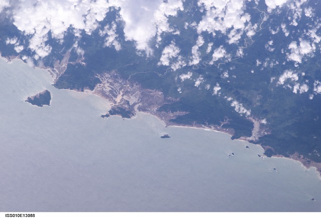
Mission: ISS010 Roll: E Frame: 13088 Mission ID on the Film or image: ISS010Country or Geographic Name: INDONESIA-S
Features: RAYA I., GLINT, TSUNAMI DAMAGE
Center Point Latitude: 4.8 Center Point Longitude: 95.5 (Negative numbers indicate south for latitude and west for longitude)
Stereo: (Yes indicates there is an adjacent picture of the same area)
ONC Map ID: JNC Map ID:
Camera
Camera Tilt: 54Camera Focal Length: 400mm
Camera: E4: Kodak DCS760C Electronic Still Camera
Film: 3060E : 3060 x 2036 pixel CCD, RGBG array.
Quality
Film Exposure:Percentage of Cloud Cover: 25 (11-25)
Nadir
Date: 20050115 (YYYYMMDD)GMT Time: 074534 (HHMMSS)Nadir Point Latitude: 8.4, Longitude: 97.9 (Negative numbers indicate south for latitude and west for longitude)
Nadir to Photo Center Direction: Southwest
Sun Azimuth: 226 (Clockwise angle in degrees from north to the sun measured at the nadir point)
Spacecraft Altitude: 190 nautical miles (352 km)
Sun Elevation Angle: 47 (Angle in degrees between the horizon and the sun, measured at the nadir point)
Orbit Number: 3165
Captions
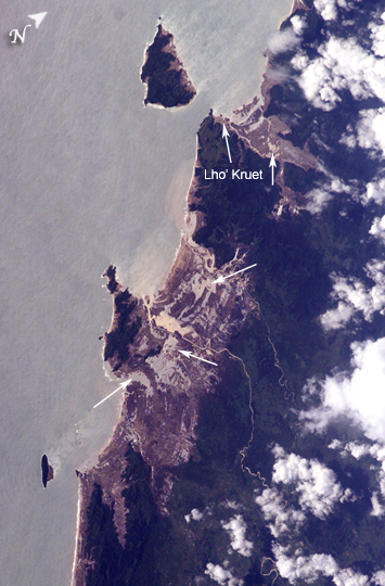
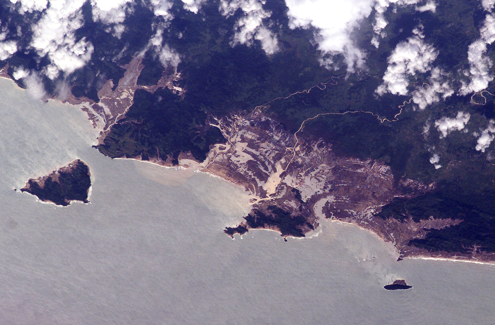
Tsunami Damage, Northwestern Sumatra (Indonesia)On December 26, 2004, a large (magnitude 9.0) earthquake occurred off the western coast of Sumatra in the Indian Ocean. The earthquake was caused by the release of stresses accumulated as the Burma tectonic plate overrides the India tectonic plate. Movement of the seafloor due to the earthquake generated a tsunami, or seismic sea wave, that affected coastal regions around the Indian Ocean. The northwestern Sumatra coastline in particular suffered extensive damage and loss of life. These astronaut photographs illustrate damage along the southwestern coast of Aceh Province in the vicinity of the city of Lho’ Kruet, Indonesia.
Large areas of bare and disturbed soil (brownish gray) that were previously covered with vegetation are visible along the coastline in the near-nadir (top) image. Embayments in the coastline were particularly hard hit, while adjacent headlands were less affected. The oblique (lower) astronaut photograph was acquired 45 seconds after the near-nadir photograph, and captures sunglint illuminating the Indian Ocean and standing water inland (light gray, yellow). Distortion and scale differences in the images are caused by increased obliquity of the view from the International Space Station. Arrows on the photographs indicate several points of comparison between the two images. Standing bodies of seawater may inhibit revegetation of damaged areas and act as sources of salt contamination in soil and groundwater.
Download Packaged File.
This option downloads the following items, packaged into a single file, if they are available:
- Browse image
- Cataloged information with captions
- Camera file
- Sound file
Server: 2 |
This service is provided by the International Space Station program. |
Recommended Citation: |
||

