| Home >> | Advanced Search >> |
 |
|
Astronaut Photography of Earth - Display Record
ISS011-E-12863

Low-resolution Browse Image
(Most browse images are not color adjusted.)Images
Conditions for Use of Images >>Image Transformation Tutorial >> Saving, Color Adjusting, and Printing Images >>
Images to View on Your Computer Now
| File Name | File Size (bytes) | Width | Height | Annotated | Cropped | Purpose | Comments | |
|---|---|---|---|---|---|---|---|---|
| View | ISS011-E-12863.JPG | 108885 | 639 | 435 | No | No | ||
| View | ISS011-E-12863.JPG | 332547 | 540 | 357 | No | Yes | NASA's Earth Observatory web site |
Large Images to Request for Downloading
| File Name | File Size (bytes) | Width | Height | Annotated | Cropped | Purpose | Comments | |
|---|---|---|---|---|---|---|---|---|
| Request | ISS011-E-12863.JPG | 971504 | 1000 | 662 | No | Yes | NASA's Earth Observatory web site | |
| Request | ISS011-E-12863.JPG | 1221401 | 3032 | 2008 | No | No | Not enhanced | Converted to JPEG from a raw image |
Download a Keyhole Markup Language (KML) file for use in Google Earth.
Electronic Image Data
Camera Files >> No sound file available.Identification
Mission: ISS011 Roll: E Frame: 12863 Mission ID on the Film or image: ISS011Country or Geographic Name: USA-WYOMING
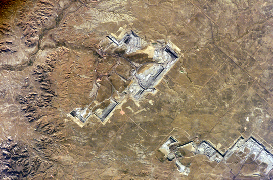
Features: LITTLE THUNDER CR., STRIP MINE
Center Point Latitude: 43.8 Center Point Longitude: -105.2 (Negative numbers indicate south for latitude and west for longitude)
Stereo: (Yes indicates there is an adjacent picture of the same area)
ONC Map ID: JNC Map ID:
Camera
Camera Tilt: 4Camera Focal Length: 400mm
Camera: E4: Kodak DCS760C Electronic Still Camera
Film: 3060E : 3060 x 2036 pixel CCD, RGBG array.
Quality
Film Exposure:Percentage of Cloud Cover: 10 (0-10)
Nadir
Date: 20050911 (YYYYMMDD)GMT Time: 223917 (HHMMSS)Nadir Point Latitude: 43.9, Longitude: -105.0 (Negative numbers indicate south for latitude and west for longitude)
Nadir to Photo Center Direction:
Sun Azimuth: 248 (Clockwise angle in degrees from north to the sun measured at the nadir point)
Spacecraft Altitude: 186 nautical miles (344 km)
Sun Elevation Angle: 27 (Angle in degrees between the horizon and the sun, measured at the nadir point)
Orbit Number: 2933
Captions
North Antelope Rochelle Coal Mine, WyomingThe United States’ highest rate of coal production is in Wyoming, with almost 400 million short tons extracted in 2004. The majority of this coal is burned to generate electrical power within the United States, but a small percentage is also goes to Spain and Canada. The Powder River Basin in the northeastern portion of the state is the most productive of Wyoming’s coal fields. The extensive coal deposits - ranging in thickness from 21 to 53 meters (70 to 175 feet) - formed over 38-66 million years ago. The source of organic material for the coal originated in swamps, estuaries, and deltas associated with the regression (retreat) of a large inland seaway that occupied central North America during the Cretaceous Period, which spanned the years between about 144 to 65 million years ago.
Open-pit strip mining is the technique that coal operators prefer for removing the sparsely vegetated surface (overburden in mining terminology) of northeastern Wyoming that covers the coal seams. One of the largest of these mines, Peabody Energy’s North Antelope Rochelle Complex, is located at the center of this astronaut photograph. A portion of Arch Coal’s Black Thunder Mine Complex is visible to north. Active coal seam faces are visible as black lines, and the stepped benches along the sides of the pit allow access for trucks carrying coal and overburden from the mine. Large draglines and shovels remove the overburden and expose the coal seam; blasting reduces the coal to loadable fragments. The coal is then transported from Wyoming by up to 2000 rail cars per day. Following removal of the coal, mining companies are required by federal law to reclaim and revegetate the former mine workings.
Download Packaged File.
This option downloads the following items, packaged into a single file, if they are available:
- Browse image
- Cataloged information with captions
- Camera file
- Sound file
Server: 2 |
This service is provided by the International Space Station program. |
Recommended Citation: |
||

