| Home >> | Advanced Search >> |
 |
|
Astronaut Photography of Earth - Display Record
ISS004-E-12328
Low-resolution Browse Image
(Most browse images are not color adjusted.)Images
Conditions for Use of Images >>Image Transformation Tutorial >> Saving, Color Adjusting, and Printing Images >>
Images to View on Your Computer Now
| File Name | File Size (bytes) | Width | Height | Annotated | Cropped | Purpose | Comments | |
|---|---|---|---|---|---|---|---|---|
| View | ISS004-E-12328.JPG | 109776 | 639 | 435 | No | No | ||
| View | ISS004-E-12328.JPG | 110144 | 540 | 851 | Yes | Yes | NASA's Earth Observatory web site | |
| View | ISS004-E-12328_2.JPG | 365063 | 487 | 768 | Yes | Yes | NASA's Earth Observatory web site | |
| View | ISS004-E-12328.JPG | 1091367 | 1000 | 777 | No | Yes | NASA's Earth Observatory web site |
Large Images to Request for Downloading
| File Name | File Size (bytes) | Width | Height | Annotated | Cropped | Purpose | Comments | |
|---|---|---|---|---|---|---|---|---|
| Request | ISS004-E-12328.JPG | 1662100 | 3032 | 2064 | No | No |
Download a Keyhole Markup Language (KML) file for use in Google Earth.
Electronic Image Data
Camera Files >> No sound file available.Identification
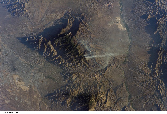
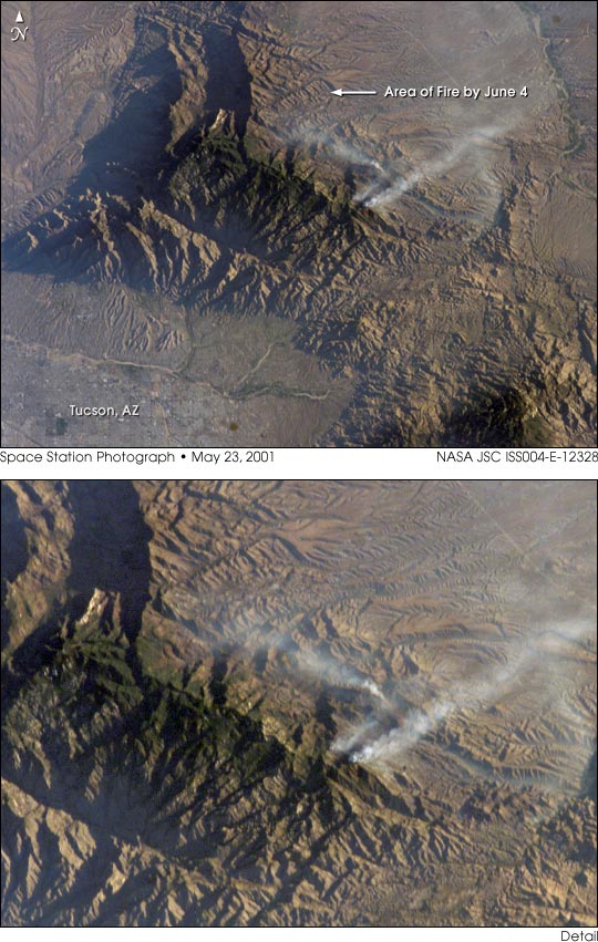
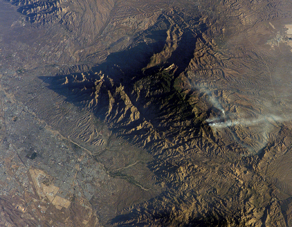
Mission: ISS004 Roll: E Frame: 12328 Mission ID on the Film or image: ISS004Country or Geographic Name: USA-ARIZONA
Features: BULLOCK FIRE NEAR TUCSON
Center Point Latitude: 32.5 Center Point Longitude: -110.5 (Negative numbers indicate south for latitude and west for longitude)
Stereo: (Yes indicates there is an adjacent picture of the same area)
ONC Map ID: JNC Map ID:
Camera
Camera Tilt: 44Camera Focal Length: 180mm
Camera: E4: Kodak DCS760C Electronic Still Camera
Film: 3060E : 3060 x 2036 pixel CCD, RGBG array.
Quality
Film Exposure:Percentage of Cloud Cover: 10 (0-10)
Nadir
Date: 20020523 (YYYYMMDD)GMT Time: 131520 (HHMMSS)Nadir Point Latitude: 29.4, Longitude: -109.3 (Negative numbers indicate south for latitude and west for longitude)
Nadir to Photo Center Direction: North
Sun Azimuth: 72 (Clockwise angle in degrees from north to the sun measured at the nadir point)
Spacecraft Altitude: 206 nautical miles (382 km)
Sun Elevation Angle: 10 (Angle in degrees between the horizon and the sun, measured at the nadir point)
Orbit Number: 4022
Captions
This image of the Bullock Fire was taken by the crew of the International Space Station using a digital camera on May 23, 2002, two days after the fire began. By May 25, fighting the fire was listed as the top national priority. The mountainous region of the Coronado National Forest, northeast of Tucson, Arizona, is highlighted by the low sun angle when the photograph was taken. Around 30,560 acres were consumed by the blaze (which was 85% contained by June 3) but it is still considered dangerous.Download Packaged File.
This option downloads the following items, packaged into a single file, if they are available:
- Browse image
- Cataloged information with captions
- Camera file
- Sound file
Server: 2 |
This service is provided by the International Space Station program. |
Recommended Citation: |
||

