| Home >> | Advanced Search >> |
 |
|
Astronaut Photography of Earth - Display Record
ISS005-E-11900

Low-resolution Browse Image
(Most browse images are not color adjusted.)Images
Conditions for Use of Images >>Image Transformation Tutorial >> Saving, Color Adjusting, and Printing Images >>
Images to View on Your Computer Now
| File Name | File Size (bytes) | Width | Height | Annotated | Cropped | Purpose | Comments | |
|---|---|---|---|---|---|---|---|---|
| View | ISS005-E-11900.JPG | 57752 | 639 | 435 | No | No | From STIC, color adjusted | |
| View | ISS005-E-11900.JPG | 69820 | 540 | 540 | Yes | Yes | NASA's Earth Observatory web site | |
| View | ISS005-E-11900.JPG | 213892 | 348 | 540 | Photographic Highlights | (540 px resized images) | ||
| View | ISS005-E-11900_2.JPG | 526740 | 495 | 768 | Photographic Highlights | (actual files used) | ||
| View | ISS005-E-11900.JPG | 1549335 | 1000 | 1469 | No | No | NASA's Earth Observatory web site |
Large Images to Request for Downloading
| File Name | File Size (bytes) | Width | Height | Annotated | Cropped | Purpose | Comments | |
|---|---|---|---|---|---|---|---|---|
| Request | ISS005-E-11900.JPG | 1339182 | 3032 | 2064 | No | No | From STIC, color adjusted |
Download a Keyhole Markup Language (KML) file for use in Google Earth.
Electronic Image Data
Camera Files >> No sound file available.Identification
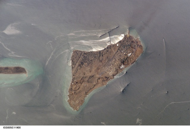
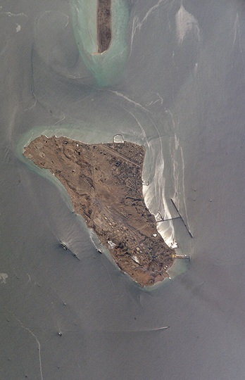
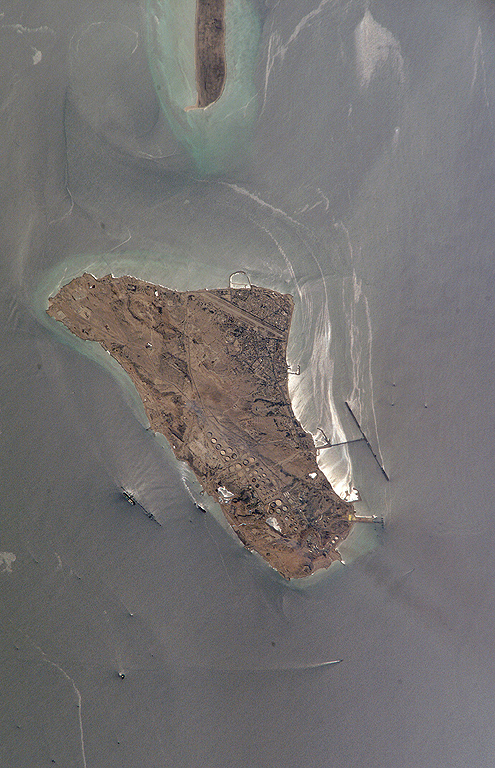
Mission: ISS005 Roll: E Frame: 11900 Mission ID on the Film or image: ISS005Country or Geographic Name: IRAN
Features: KHARG ISLAND, OIL SLICK, SUNGLINT
Center Point Latitude: 29.5 Center Point Longitude: 50.5 (Negative numbers indicate south for latitude and west for longitude)
Stereo: (Yes indicates there is an adjacent picture of the same area)
ONC Map ID: JNC Map ID:
Camera
Camera Tilt: 36Camera Focal Length: 800mm
Camera: E4: Kodak DCS760C Electronic Still Camera
Film: 3060E : 3060 x 2036 pixel CCD, RGBG array.
Quality
Film Exposure:Percentage of Cloud Cover: 10 (0-10)
Nadir
Date: 20020831 (YYYYMMDD)GMT Time: 102559 (HHMMSS)Nadir Point Latitude: 29.5, Longitude: 53.0 (Negative numbers indicate south for latitude and west for longitude)
Nadir to Photo Center Direction: West
Sun Azimuth: 239 (Clockwise angle in degrees from north to the sun measured at the nadir point)
Spacecraft Altitude: 206 nautical miles (382 km)
Sun Elevation Angle: 56 (Angle in degrees between the horizon and the sun, measured at the nadir point)
Orbit Number: 1580
Captions
Kharg Island is Iran’s primary oil export terminal in the Persian Gulf. This rocky limestone island is unique because it is one of the few islands in the Persian Gulf with freshwater which has collected within the porous limestone. In addition to its commercial and strategic importance, the freshwater has biological importance, supporting populations of gazelles. This high-resolution photograph taken by astronauts on board the International Space Station shows detail of the tanker dock facilities, tanks and other infrastructure. Sunglint on the surface of the water highlights small amounts of oil on the sea surface and reveals the direction of the local currents.Download Packaged File.
This option downloads the following items, packaged into a single file, if they are available:
- Browse image
- Cataloged information with captions
- Camera file
- Sound file
Server: 2 |
This service is provided by the International Space Station program. |
Recommended Citation: |
||

