| Home >> | Advanced Search >> |
 |
|
Astronaut Photography of Earth - Display Record
ISS014-E-11872
Low-resolution Browse Image
(Most browse images are not color adjusted.)Images
Conditions for Use of Images >>Image Transformation Tutorial >> Saving, Color Adjusting, and Printing Images >>
Images to View on Your Computer Now
| File Name | File Size (bytes) | Width | Height | Annotated | Cropped | Purpose | Comments | |
|---|---|---|---|---|---|---|---|---|
| View | ISS014-E-11872.JPG | 36871 | 639 | 435 | No | No | ||
| View | ISS014-E-11872.JPG | 160228 | 540 | 396 | Yes | Yes | NASA's Earth Observatory web site |
Large Images to Request for Downloading
| File Name | File Size (bytes) | Width | Height | Annotated | Cropped | Purpose | Comments | |
|---|---|---|---|---|---|---|---|---|
| Request | ISS014-E-11872.JPG | 431569 | 1000 | 734 | No | Yes | NASA's Earth Observatory web site | |
| Request | ISS014-E-11872.JPG | 550726 | 3032 | 2064 | No | No |
Download a Keyhole Markup Language (KML) file for use in Google Earth.
Electronic Image Data
Camera Files >> No sound file available.Identification
Mission: ISS014 Roll: E Frame: 11872 Mission ID on the Film or image: ISS014Country or Geographic Name: NORTHERN MARIANA IS.
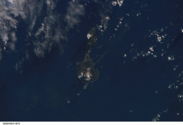
Features: PAGAN, VOLCANOS, ASH PLUME
Center Point Latitude: 18.0 Center Point Longitude: 146.0 (Negative numbers indicate south for latitude and west for longitude)
Stereo: (Yes indicates there is an adjacent picture of the same area)
ONC Map ID: JNC Map ID:
Camera
Camera Tilt: 19Camera Focal Length: 180mm
Camera: E4: Kodak DCS760C Electronic Still Camera
Film: 3060E : 3060 x 2036 pixel CCD, RGBG array.
Quality
Film Exposure:Percentage of Cloud Cover: 25 (11-25)
Nadir
Date: 20070111 (YYYYMMDD)GMT Time: 065721 (HHMMSS)Nadir Point Latitude: 18.1, Longitude: 145.0 (Negative numbers indicate south for latitude and west for longitude)
Nadir to Photo Center Direction: East
Sun Azimuth: 242 (Clockwise angle in degrees from north to the sun measured at the nadir point)
Spacecraft Altitude: 180 nautical miles (333 km)
Sun Elevation Angle: 13 (Angle in degrees between the horizon and the sun, measured at the nadir point)
Orbit Number: 2599
Captions
Pagan Island, Northern Mariana Islands:The Mariana Islands are part a volcanic island arc—surface volcanoes formed from magma generated as one tectonic plate overrides another. In the case of the Mariana Islands, the Pacific Plate is being pulled, or subducted, beneath the Philippine Plate along the famously deep Mariana Trench, which is more than 11 kilometers (nearly 7 miles) below sea level. Pagan Island (image right) is made up of two volcanoes connected by a narrow isthmus of land. The volcanoes are stratovolcanoes, which are tall, typically cone-shaped structures formed by layers of dense, crystallized lava and less-dense ash and pumice. Mount Pagan, the larger of the two volcanoes, forms the northeastern portion of the island and has been the most active historically.
The most recent major eruption took place in 1981, but since then numerous steam- and ash-producing events have been observed at the volcano—the latest reported one occurring between December 5–8, 2006. This astronaut photograph records volcanic activity on January 11, 2007, that produced a thin plume that extended westwards away from Mount Pagan. The plume was most probably steam, possibly with minor ash content. The island is sparsely populated, and it is monitored for volcanic activity by the United States Geological Survey and the Commonwealth of the Mariana Islands.
Download Packaged File.
This option downloads the following items, packaged into a single file, if they are available:
- Browse image
- Cataloged information with captions
- Camera file
- Sound file
Server: 2 |
This service is provided by the International Space Station program. |
Recommended Citation: |
||

