| Home >> | Advanced Search >> |
 |
|
Astronaut Photography of Earth - Display Record
ISS007-E-11256
Low-resolution Browse Image
(Most browse images are not color adjusted.)Images
Conditions for Use of Images >>Image Transformation Tutorial >> Saving, Color Adjusting, and Printing Images >>
Images to View on Your Computer Now
| File Name | File Size (bytes) | Width | Height | Annotated | Cropped | Purpose | Comments | |
|---|---|---|---|---|---|---|---|---|
| View | ISS007-E-11256.JPG | 84629 | 639 | 435 | No | No | ||
| View | ISS007-E-11256.JPG | 103681 | 540 | 405 | Yes | Yes | NASA's Earth Observatory web site | |
| View | ISS007-E-11256.JPG | 103681 | 540 | 405 | Yes | Yes | NASA's Earth Observatory web site | Color adjusted |
| View | ISS007-E-11256.JPG | 158147 | 540 | 597 | Photographic Highlights | (resized 540 px images) | ||
| View | ISS007-E-11256_2.JPG | 246297 | 695 | 768 | Photographic Highlights | (actual files used) | ||
| View | ISS007-E-11256.JPG | 1177161 | 1000 | 1100 | No | Yes | NASA's Earth Observatory web site | Cropped and rotated |
Large Images to Request for Downloading
| File Name | File Size (bytes) | Width | Height | Annotated | Cropped | Purpose | Comments | |
|---|---|---|---|---|---|---|---|---|
| Request | ISS007-E-11256.JPG | 1231874 | 3032 | 2064 | No | No | ||
| Request | ISS007-E-11256_2.JPG | 6959119 | 6144 | 4068 | No | No | Presentation | Earth Sciences Results Briefing/Ed Lu |
Download a Keyhole Markup Language (KML) file for use in Google Earth.
Electronic Image Data
Camera Files >> No sound file available.Identification
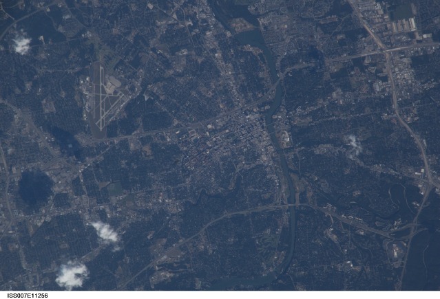
Mission: ISS007 Roll: E Frame: 11256 Mission ID on the Film or image: ISS007Country or Geographic Name: USA-TEXAS
Features: AUSTIN, COLORADO RIVER, AIRPORT
Center Point Latitude: 30.5 Center Point Longitude: -97.5 (Negative numbers indicate south for latitude and west for longitude)
Stereo: (Yes indicates there is an adjacent picture of the same area)
ONC Map ID: JNC Map ID:
Camera
Camera Tilt: 38Camera Focal Length: 800mm
Camera: E4: Kodak DCS760C Electronic Still Camera
Film: 3060E : 3060 x 2036 pixel CCD, RGBG array.
Quality
Film Exposure:Percentage of Cloud Cover: 10 (0-10)
Nadir
Date: 20030729 (YYYYMMDD)GMT Time: 224339 (HHMMSS)Nadir Point Latitude: 28.0, Longitude: -98.3 (Negative numbers indicate south for latitude and west for longitude)
Nadir to Photo Center Direction: North
Sun Azimuth: 275 (Clockwise angle in degrees from north to the sun measured at the nadir point)
Spacecraft Altitude: 204 nautical miles (378 km)
Sun Elevation Angle: 34 (Angle in degrees between the horizon and the sun, measured at the nadir point)
Orbit Number: 2768
Captions
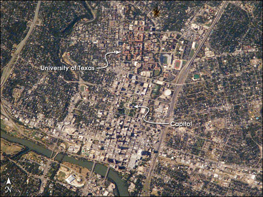
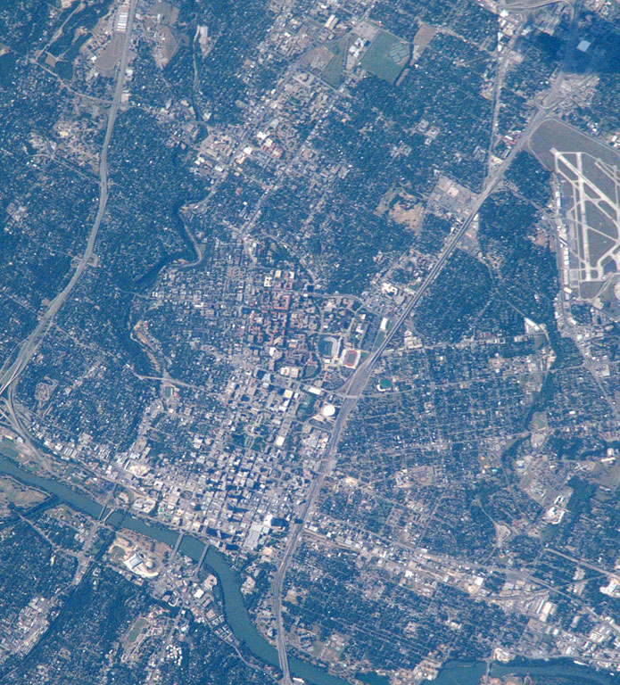
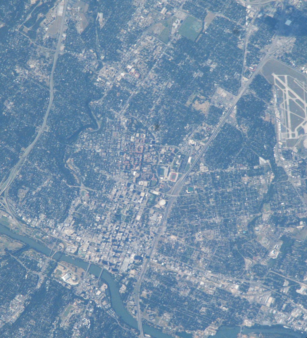
It was Texas hot when this view of the capital city of Austin was taken in late July by astronaut Ed Lu. Adding to the rising temperatures were heated debates in the Texas Capitol Building, where a special session had convened. Eleven democratic senators thwarted a redistricting vote by disappearing from the state. Were Lu, and his Expedition 7 partner Yuri Malenchenko looking for the missing democratic senators? We’ll never know, but they expanded their Austin search a week later with a wider view of Austin, taken with a 400 mm lens on August 6.Austin is an expanding city in the Texas hill country. A few decades ago Austin was known as a place where University of Texas students and state politicians co-existed along the banks of the Colorado River (seen snaking along the lower left of the image). Today, the exploding population (44% growth between 1990 and 2000) and increasing development stresses local resources like water, green space, and transportation networks, prompting city planners to think through scenarios for future development.
Documenting city environments and city footprints over time is one of the science objectives of the Crew Earth Observations payload on the International Space Station. Astronauts have always enjoyed observing cities around the world. These images of Austin provide a 2003 baseline for monitoring its regional development and growth.
Download Packaged File.
This option downloads the following items, packaged into a single file, if they are available:
- Browse image
- Cataloged information with captions
- Camera file
- Sound file
Server: 2 |
This service is provided by the International Space Station program. |
Recommended Citation: |
||

