| Home >> | Advanced Search >> |
 |
|
Astronaut Photography of Earth - Display Record
ISS004-E-10319
Low-resolution Browse Image
(Most browse images are not color adjusted.)Images
Conditions for Use of Images >>Image Transformation Tutorial >> Saving, Color Adjusting, and Printing Images >>
Images to View on Your Computer Now
| File Name | File Size (bytes) | Width | Height | Annotated | Cropped | Purpose | Comments | |
|---|---|---|---|---|---|---|---|---|
| View | ISS004-E-10319.JPG | 90047 | 639 | 435 | No | No | From STIC, color adjusted | |
| View | ISS004-E-10319.JPG | 320055 | 540 | 380 | Photographic Highlights | 540 px resized images | ||
| View | ISS004-E-10319.JPG | 413128 | 540 | 439 | Yes | Yes | NASA's Earth Observatory web site |
Large Images to Request for Downloading
| File Name | File Size (bytes) | Width | Height | Annotated | Cropped | Purpose | Comments | |
|---|---|---|---|---|---|---|---|---|
| Request | ISS004-E-10319.JPG | 1078294 | 1024 | 768 | Photographic Highlights | actual files used | ||
| Request | ISS004-E-10319.JPG | 1306382 | 3032 | 2064 | No | No | From STIC, color adjusted |
Download a Keyhole Markup Language (KML) file for use in Google Earth.
Electronic Image Data
Camera Files >> No sound file available.Identification
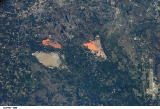
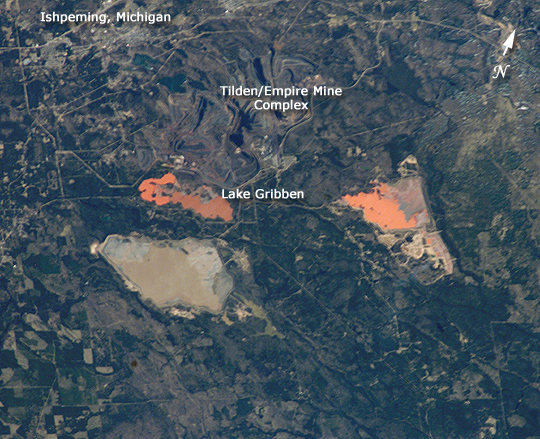
Mission: ISS004 Roll: E Frame: 10319 Mission ID on the Film or image: ISS004Country or Geographic Name: USA-MICHIGAN
Features: LAKE GRIBBEN, SAWYER AFB
Center Point Latitude: 46.5 Center Point Longitude: -87.5 (Negative numbers indicate south for latitude and west for longitude)
Stereo: (Yes indicates there is an adjacent picture of the same area)
ONC Map ID: JNC Map ID:
Camera
Camera Tilt: 45Camera Focal Length: 400mm
Camera: E4: Kodak DCS760C Electronic Still Camera
Film: 3060E : 3060 x 2036 pixel CCD, RGBG array.
Quality
Film Exposure:Percentage of Cloud Cover: 10 (0-10)
Nadir
Date: 20020422 (YYYYMMDD)GMT Time: 214512 (HHMMSS)Nadir Point Latitude: 47.1, Longitude: -84.1 (Negative numbers indicate south for latitude and west for longitude)
Nadir to Photo Center Direction: West
Sun Azimuth: 258 (Clockwise angle in degrees from north to the sun measured at the nadir point)
Spacecraft Altitude: 210 nautical miles (389 km)
Sun Elevation Angle: 28 (Angle in degrees between the horizon and the sun, measured at the nadir point)
Orbit Number: 3544
Captions
Astronauts onboard the International Space Station often observe small, otherwise unnoticed water bodies on the ground due to their unusual colors. Such a lake with color linked commercial activity is Lake Gribben, located to the southeast of Ishpeming in Michigan’s Upper Peninsula. Iron ore is extracted from the Tilden/Empire Mine complex visible to the north of the lake.Link to Earth Observatory Caption >>
Download Packaged File.
This option downloads the following items, packaged into a single file, if they are available:
- Browse image
- Cataloged information with captions
- Camera file
- Sound file
Server: 2 |
This service is provided by the International Space Station program. |
Recommended Citation: |
||

