| Home >> | Advanced Search >> |
 |
|
Astronaut Photography of Earth - Display Record
STS005-39-1022
Low-resolution Browse Image
(Most browse images are not color adjusted.)Images
Conditions for Use of Images >>Image Transformation Tutorial >> Saving, Color Adjusting, and Printing Images >>
Images to View on Your Computer Now
| File Name | File Size (bytes) | Width | Height | Annotated | Cropped | Purpose | Comments | |
|---|---|---|---|---|---|---|---|---|
| View | STS005-39-1022.JPG | 30078 | 640 | 480 | No | No | ISD 1 |
Large Images to Request for Downloading
| File Name | File Size (bytes) | Width | Height | Annotated | Cropped | Purpose | Comments | |
|---|---|---|---|---|---|---|---|---|
| Request | STS005-39-1022_2.TIF | 3264856 | 1304 | 1282 | No | No | ||
| Request | STS005-39-1022.TIF | 11430474 | 2608 | 2564 | No | No |
Download a Keyhole Markup Language (KML) file for use in Google Earth.
Electronic Image Data
Camera files only apply to electronic still cameras.No sound file available.
Identification
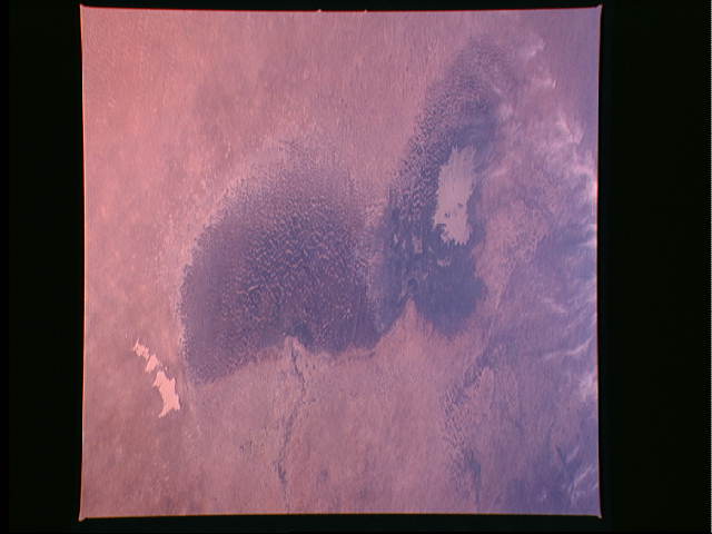
Mission: STS005 Roll: 39 Frame: 1022 Mission ID on the Film or image: STS-5Country or Geographic Name: CHAD
Features: LAKE CHAD
Center Point Latitude: 13.7 Center Point Longitude: 13.8 (Negative numbers indicate south for latitude and west for longitude)
Stereo: No (Yes indicates there is an adjacent picture of the same area)
ONC Map ID: KO3 JNC Map ID:
Camera
Camera Tilt: Low ObliqueCamera Focal Length: 100mm
Camera: HB: Hasselblad
Film: 5017 : Kodak, natural color positive, Ektachrome, X Professional, ASA 64, standard base.
Quality
Film Exposure: NormalPercentage of Cloud Cover: 5 (0-10)
Nadir
Date: 198211__ (YYYYMMDD)GMT Time: (HHMMSS)Nadir Point Latitude: , Longitude: (Negative numbers indicate south for latitude and west for longitude)
Nadir to Photo Center Direction:
Sun Azimuth: (Clockwise angle in degrees from north to the sun measured at the nadir point)
Spacecraft Altitude: nautical miles (0 km)
Sun Elevation Angle: (Angle in degrees between the horizon and the sun, measured at the nadir point)
Orbit Number: 30
Captions
Once a great inland lake, Lake Chad (13.0N, 14.0E) in the Sahara Desert at the intersection of the African nations of Chad, Niger, Nigeria and Cameroon, is now in decline. The larger northern lobe is almost totally dry and slowly filling in with encroaching sand dunes. The southern lobe, still retains some water in the lower center but the water surface area is less than 2000 square kilometers and sand dunes are filling in the north end.Download Packaged File.
This option downloads the following items, packaged into a single file, if they are available:
- Browse image
- Cataloged information with captions
- Camera file
- Sound file
Server: 2 |
This service is provided by the International Space Station program. |
Recommended Citation: |
||

