| Home >> | Advanced Search >> |
 |
|
Astronaut Photography of Earth - Display Record
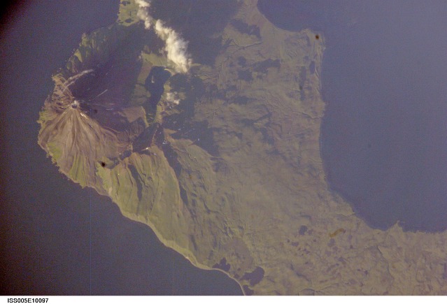
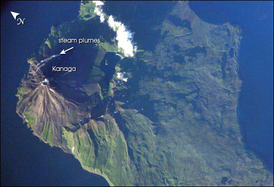
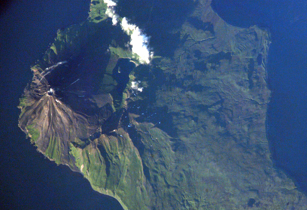
ISS005-E-10097
Low-resolution Browse Image
(Most browse images are not color adjusted.)Images
Conditions for Use of Images >>Image Transformation Tutorial >> Saving, Color Adjusting, and Printing Images >>
Images to View on Your Computer Now
| File Name | File Size (bytes) | Width | Height | Annotated | Cropped | Purpose | Comments | |
|---|---|---|---|---|---|---|---|---|
| View | ISS005-E-10097.JPG | 57883 | 540 | 369 | Yes | Yes | NASA's Earth Observatory web site | |
| View | ISS005-E-10097.JPG | 64739 | 639 | 435 | No | No | From STIC, color adjusted | |
| View | ISS005-E-10097.JPG | 860308 | 1000 | 684 | No | Yes | NASA's Earth Observatory web site |
Large Images to Request for Downloading
| File Name | File Size (bytes) | Width | Height | Annotated | Cropped | Purpose | Comments | |
|---|---|---|---|---|---|---|---|---|
| Request | ISS005-E-10097.JPG | 444024 | 2368 | 1620 | No | Yes | NASA's Earth Observatory web site | Color adjusted |
| Request | ISS005-E-10097.JPG | 1964285 | 3032 | 2064 | No | No | From STIC, color adjusted | |
| Request | ISS005-E-10097.TIF | 18277968 | 3032 | 2008 | No | No | From STIC, color adjusted |
Download a Keyhole Markup Language (KML) file for use in Google Earth.
Electronic Image Data
Camera Files >> No sound file available.Identification
Mission: ISS005 Roll: E Frame: 10097 Mission ID on the Film or image: ISS005Country or Geographic Name: USA-ALASKA
Features: KANAGA ISLAND, VOLCANO
Center Point Latitude: 52.0 Center Point Longitude: -177.0 (Negative numbers indicate south for latitude and west for longitude)
Stereo: (Yes indicates there is an adjacent picture of the same area)
ONC Map ID: JNC Map ID:
Camera
Camera Tilt: 31Camera Focal Length: 800mm
Camera: E4: Kodak DCS760C Electronic Still Camera
Film: 3060E : 3060 x 2036 pixel CCD, RGBG array.
Quality
Film Exposure:Percentage of Cloud Cover: 10 (0-10)
Nadir
Date: 20020814 (YYYYMMDD)GMT Time: 054647 (HHMMSS)Nadir Point Latitude: 50.0, Longitude: -177.4 (Negative numbers indicate south for latitude and west for longitude)
Nadir to Photo Center Direction: North
Sun Azimuth: 278 (Clockwise angle in degrees from north to the sun measured at the nadir point)
Spacecraft Altitude: 204 nautical miles (378 km)
Sun Elevation Angle: 12 (Angle in degrees between the horizon and the sun, measured at the nadir point)
Orbit Number: 1312
Captions
The symmetrical cone of Kanaga volcano stands out on the northern corner of Kanaga Island, located in the central part of Alaska’s Aleutian archipelago. Kanaga last erupted in 1994 and is well known for its active fumaroles and hot springs (located, in this image, by fine steam plumes on the northeast flank of the volcano). A small lake to the southeast of the cone is situated on the floor of a larger more ancient volcanic caldera. The crew of the international space station acquired this image late in the day of August 13, 2002. Note how the late summer sun accentuates the terrain features like the volcanic flows that radiate down from the volcano’s peak, and the steep cliffs along the western coastline.Download Packaged File.
This option downloads the following items, packaged into a single file, if they are available:
- Browse image
- Cataloged information with captions
- Camera file
- Sound file
Server: 2 |
This service is provided by the International Space Station program. |
Recommended Citation: |
||

