| ||
Savannah River Site, South Carolina
| ||||
|
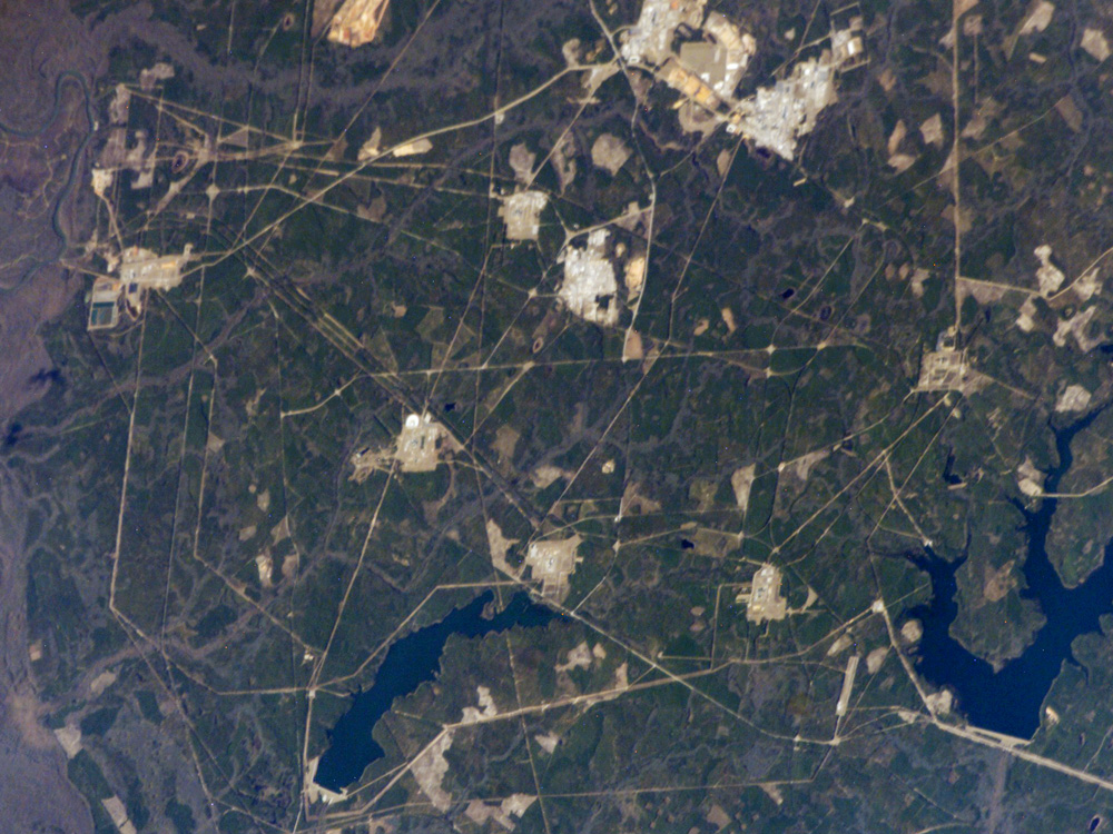
Situated between the South Carolina piedmont and the Atlantic Ocean, the Savannah River Site is an important part of the U.S. Department of Energy’s nuclear program. Construction of the site—originally called the Savannah River Plant—began in 1951 for the purpose of generating radioactive materials necessary for nuclear weapons production during the Cold War. A total of five nuclear reactors occupy the central portion of the site and operated throughout 1953–1992. Following the end of the Cold War in 1991, activities at the Savannah River Site are now focused on disposal of nuclear wastes, environmental cleanup of the site itself, and development of advanced remediation technologies. A history of the site is detailed in the book SRS at Fifty. The Savannah River Site is located in the Sand Hills region of South Carolina and includes an area of 800 square kilometers (about 300 square miles). The southern half of the site (building clusters with reflective white rooftops) is shown in this astronaut photograph. The nearby Savannah River and its tributary creeks provided a ready source of water for the nuclear reactors; to this end, two artificial lakes (“L” Lake and Par Pond) were constructed. The meandering channel of the river and its floodplain, characterized by grey-brown sediments, is visible on the far left of the image. Because the river is so close to the nuclear site and because the underlying geological materials (sand, clay, gravel, and carbonate rocks) are permeable, an extensive and ongoing environmental monitoring and cleanup effort is necessary to reduce potential contamination of local water sources. Final remediation of wastes posing threats to surface and groundwater is scheduled to occur by 2025. Astronaut photograph ISS012-E-16633 was acquired January 28, 2006, with a Kodak 760C digital camera using a 400 mm lens, and is provided by the ISS Crew Earth Observations experiment and the Image Science & Analysis Group, Johnson Space Center. The image in this article has been cropped and contrast enhanced; lens artifacts have also been removed. The International Space Station Program supports the laboratory to help astronauts take pictures of Earth that will be of the greatest value to scientists and the public, and to make those images freely available on the Internet. Additional images taken by astronauts and cosmonauts can be viewed at the NASA/JSC Gateway to Astronaut Photography of Earth. Recommend this Image to a Friend Back to: Newsroom Also see |
View Images Index
| |||
| Subscribe to the
Earth Observatory About the Earth Observatory Please send comments or questions to: eo-contact@eodomo.gsfc.nasa.gov Program Manager: David Herring Responsible NASA official: Yoram Kaufman NASA/GSFC Security and Privacy Statement |
 Click here to view full
image
Click here to view full
image