a. Synoptic History
A westward-moving tropical wave crossed Central America on 28-29 July. For the next few days, the system continued westward at 10- 15 knots over the tropical eastern Pacific, enhancing convection along the ITCZ but showing little evidence of organization. Late on 5 August, as the wave neared 120W, the associated cloud pattern become more consolidated and by 0600 UTC 6 August, the organization had improved significantly, with curved cloud bands evident on satellite images. Based on the organization of the cloud pattern, it is estimated that Tropical Depression Eight-E formed at this time, centered about 850 n mi southwest of Cabo San Lucas. Data T-numbers from the Dvorak technique suggest that the depression became a tropical storm, Eugene, by 1800 UTC 6 August, while centered about 900 n mi southwest of Cabo San Lucas.
For the first couple of days, with a slight weakness in the subtropical ridge to its north, the tropical cyclone moved generally west-northwestward at less than 10 knots. By 8 August, however, the ridge to the north of Eugene strengthened, forcing the cyclone on a westward course at 10-11 knots. Eugene intensified into a hurricane a little before 1800 UTC that day, as a small eye about 10 n mi in diameter was observed on the satellite pictures. Stronger ridging to the north caused the system to move slightly south of west, keeping it over warmer sea surface temperatures. Additional strengthening occurred until the hurricane reached its peak intensity of about 95 knots around 1800 UTC 9 August. It should be noted that this cyclone reached its maximum intensity near 133W longitude, significantly farther west than the typical location at which eastern north Pacific tropical cyclones reach their peak strength. Shortly thereafter, a slow weakening trend commenced. Eugene moved westward and entered the Central Pacific basin, as a 75-knot hurricane, early on 11 August.
In an environment of modest shear and marginal (for strengthening) sea surface temperatures, the cyclone was quite slow to wind down. Eugene eventually weakened below hurricane strength by 0000 UTC 13 August, while centered about 550 n mi east-southeast of the island of Hawaii. The storm passed a little less than 300 n mi south of the southern end of the island of Hawaii at 0600 UTC 14 August, by which time its maximum sustained winds had diminished to near 45 knots. Eugene turned west-southwestward toward a region of increasing vertical shear. The cyclone weakened to a depression later on the 14th, then turned back toward the west and dissipated, a little over 500 n mi southeast of Johnston Island, on 15 August.
b. Meteorological Statistics
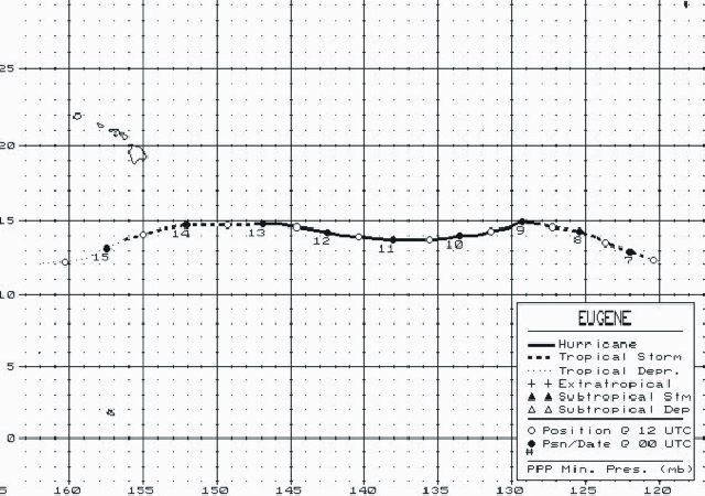
Table 1 is a listing of the post-storm "best" track positions and intensities of Eugene at six-hourly intervals. West of 140W longitude, the best track was produced by the Central Pacific Hurricane Center (CPHC) in Honolulu, Hawaii. Figure 1 is a map of the best track.
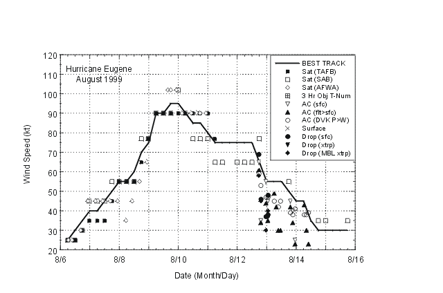
Figure 2 and Figure 3 show curves of the maximum one-minute average "surface" (10 meters above ground level) wind speed and minimum central sea-level pressure, respectively, as a function of time. Also plotted are the observations on which the curves are based, consisting of aircraft reconnaissance and dropsonde data from the U.S. Air Force Reserves (the Hurricane Hunters) as well as Dvorak-technique estimates from the Tropical Analysis and Forecast Branch (TAFB), the Satellite Analysis Branch (SAB), and the U.S. Air Force Weather Agency (AFWA) using satellite imagery. In Figure 2, the aircraft flight level wind measurements have been adjusted for elevation (90% of 700 mb wind speeds and 80% of 850 mb speeds), and dropsonde wind measurements that fail above the surface are adjusted to the 10 meter level using a mean hurricane eyewall profile determined by previous dropsonde measurements.
Prior to its entrance into the CPHC's area of responsibility, the intensity of Eugene was estimated solely on the basis of satellite images. The estimated peak strength, 95 knots, is a compromise between Dvorak estimates from AFWA, SAB, and TAFB.
c. Casualty and Damage Statistics
No reports of casualties or damages due to Eugene have been received.
d. Forecast and Warning Critique
In comparison to the long-term average, Eugene's track was reasonably well forecast, although there was almost always a slight northward bias in the National Hurricane Center and CPHC track predictions. During the strengthening phase of the tropical cyclone, practically all of the official forecasts under-predicted the intensity of Eugene, at times by as much as 30 to 35 knots. Afterwards the intensity was, for the most part, slightly over-predicted.
The CPHC correctly forecast Eugene to remain safely south of the Hawaiian island chain. Watches and/or warnings were not required.
Figure 1. Best track positions for Hurricane Eugene, 6-15 August, 1999
Figure 2. Best track maximum sustained wind speed curve for Hurricane Eugene, showing all available intensity estimates and wind observations. Aircraft flight-level winds are adjusted for elevation (90% of 700 mb flight level wind speeds and 80% of 850 mb speeds). Dropsonde wind speeds are adjusted to the surface using a mean eyewall profile determined from previous dropsonde measurements. MBL denotes mean boundary layer).
Figure 3. Best track minimum central pressure curve and central pressure observations for Hurricane Eugene.
Table 1. Best track, Hurricane Eugene, 6-15 August, 1999 Date/Time
(UTC)Position Pressure
(mb)Wind Speed
(kt)Stage Lat. (°N) Lon. (°W) 6/0600 12.2 119.9 1007 25 tropical depression 6/1200 12.3 120.4 1007 30 " 6/1800 12.6 121.1 1005 35 tropical storm 7/0000 12.9 122.0 1004 40 " 7/0600 13.2 122.8 1003 40 " 7/1200 13.5 123.6 1003 45 " 7/1800 13.9 124.4 997 50 " 8/0000 14.3 125.4 994 55 " 8/0600 14.4 126.3 994 55 " 8/1200 14.6 127.2 990 60 " 8/1800 14.8 128.2 983 70 hurricane 9/0000 14.9 129.3 979 75 " 9/0600 14.5 130.3 970 90 " 9/1200 14.3 131.4 970 90 " 9/1800 14.0 132.4 964 95 " 10/0000 14.0 133.5 965 95 " 10/0600 13.8 134.5 970 90 " 10/1200 13.7 135.6 974 85 " 10/1800 13.7 136.7 974 85 " 11/0000 13.7 138.1 977 80 " 11/0600 13.8 139.3 979 75 " 11/1200 13.9 140.4 980 75 " 11/1800 14.0 141.5 980 75 " 12/0000 14.2 142.5 985 75 " 12/0600 14.4 143.6 985 75 12/1200 14.6 144.6 985 75 " 12/1800 14.8 145.8 990 65 " 13/0000 14.8 146.9 998 55 tropical storm 13/0600 14.7 148.0 998 55 " 13/1200 14.7 149.3 999 55 " 13/1800 14.7 150.7 1003 50 " 14/0000 14.7 152.1 1002 45 " 14/0600 14.5 153.6 1004 45 " 14/1200 14.1 155.0 1004 35 " 14/1800 13.7 156.3 1004 30 tropical depression 15/0000 13.1 157.5 1006 30 " 15/0600 12.5 158.8 1006 30 " 15/1200 12.2 160.3 1006 30 " 15/1800 12.1 161.8 1006 30 " 16/0000 dissipated 9/1800 14.0 132.4 964 95 minimum pressure