| Home >> | Advanced Search >> |
 |
|
Astronaut Photography of Earth - Display Record
ISS011-E-9680
Low-resolution Browse Image
(Most browse images are not color adjusted.)Images
Conditions for Use of Images >>Image Transformation Tutorial >> Saving, Color Adjusting, and Printing Images >>
Images to View on Your Computer Now
| File Name | File Size (bytes) | Width | Height | Annotated | Cropped | Purpose | Comments | |
|---|---|---|---|---|---|---|---|---|
| View | ISS011-E-9680.JPG | 67686 | 639 | 435 | No | No | ||
| View | ISS011-E-9680.JPG | 292167 | 357 | 540 | Yes | Yes | NASA's Earth Observatory web site |
Large Images to Request for Downloading
| File Name | File Size (bytes) | Width | Height | Annotated | Cropped | Purpose | Comments | |
|---|---|---|---|---|---|---|---|---|
| Request | ISS011-E-9680.JPG | 904400 | 1000 | 661 | No | Yes | NASA's Earth Observatory web site | |
| Request | ISS011-E-9680.JPG | 911121 | 3032 | 2008 | No | No | Not enhanced | Converted to JPEG from a raw image |
Download a Keyhole Markup Language (KML) file for use in Google Earth.
Electronic Image Data
Camera Files >> No sound file available.Identification
Mission: ISS011 Roll: E Frame: 9680 Mission ID on the Film or image: ISS011Country or Geographic Name: USA-CALIFORNIA
Features: SEARLES LAKE,PLAYA,SLATE RANGE
Center Point Latitude: 35.5 Center Point Longitude: -117.5 (Negative numbers indicate south for latitude and west for longitude)
Stereo: (Yes indicates there is an adjacent picture of the same area)
ONC Map ID: JNC Map ID:
Camera
Camera Tilt: 14Camera Focal Length: 180mm
Camera: E4: Kodak DCS760C Electronic Still Camera
Film: 3060E : 3060 x 2036 pixel CCD, RGBG array.
Quality
Film Exposure:Percentage of Cloud Cover: 10 (0-10)
Nadir
Date: 20050627 (YYYYMMDD)GMT Time: 130354 (HHMMSS)Nadir Point Latitude: 34.8, Longitude: -117.1 (Negative numbers indicate south for latitude and west for longitude)
Nadir to Photo Center Direction: Northwest
Sun Azimuth: 64 (Clockwise angle in degrees from north to the sun measured at the nadir point)
Spacecraft Altitude: 188 nautical miles (348 km)
Sun Elevation Angle: 4 (Angle in degrees between the horizon and the sun, measured at the nadir point)
Orbit Number: 1731
Captions
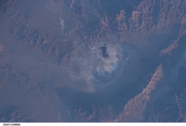
Searles Lake, CaliforniaSearles Lake is known for the abundance of rare elements and evaporate minerals, such as trona, hanksite, and halite formed within its sediments. Evaporites are minerals that are left behind when saltwater evaporates. During the Pleistocene Epoch (beginning approximately 2 million years ago), Searles Lake was one of a chain of lakes fed by streamflow from the Sierra Nevada to the west. Lake levels rose and fell dependant on glacial outwash from the Sierra Nevada as climate shifted. Successive layers of sediment were deposited as lake levels fluctuated, preserving an important record of regional climate change. The lakes gradually dried up completely as climatic conditions became hotter and drier (as today), forming a string of playas—enclosed basins with no outlets.
This astronaut photograph depicts the Searles Lake playa (characterized by white surface mineral deposits) bounded by the Argus and Slate Mountains. The width of the playa is approximately 10 kilometers. The center of the image is dominated by mining operations that extract sodium- and potassium-rich minerals (primarily borax and salt) for industrial use. Minerals are primarily found in naturally occurring, subsurface brines, which are pumped to the surface and evaporated to crystallize the minerals. A large evaporation pond (black) is visible in the center of the image. Further processing concentrates the minerals and removes excess water.
Download Packaged File.
This option downloads the following items, packaged into a single file, if they are available:
- Browse image
- Cataloged information with captions
- Camera file
- Sound file
Server: 2 |
This service is provided by the International Space Station program. |
Recommended Citation: |
||

