| Home >> | Advanced Search >> |
 |
|
Astronaut Photography of Earth - Display Record
ISS002-E-5654

Low-resolution Browse Image
(Most browse images are not color adjusted.)Images
Conditions for Use of Images >>Image Transformation Tutorial >> Saving, Color Adjusting, and Printing Images >>
Images to View on Your Computer Now
| File Name | File Size (bytes) | Width | Height | Annotated | Cropped | Purpose | Comments | |
|---|---|---|---|---|---|---|---|---|
| View | ISS002-E-5654.JPG | 45370 | 540 | 358 | Yes | No | NASA's Earth Observatory web site | |
| View | ISS002-E-5654_2.JPG | 72010 | 437 | 640 | No | No | ||
| View | ISS002-E-5654.JPG | 122352 | 400 | 265 | No | No | Photographic Highlights | |
| View | ISS002-E-5654.JPG | 148732 | 540 | 369 | Photographic Highlights | (540px resized images) | ||
| View | ISS002-E-5654.JPG | 296907 | 540 | 405 | Scientist Request | Online Publication | ||
| View | ISS002-E-5654.JPG | 1064452 | 3060 | 2027 | No | No | NASA's Earth Observatory web site |
Large Images to Request for Downloading
| File Name | File Size (bytes) | Width | Height | Annotated | Cropped | Purpose | Comments | |
|---|---|---|---|---|---|---|---|---|
| Request | ISS002-E-5654.JPG | 464999 | 1024 | 700 | Photographic Highlights | actual files used | ||
| Request | ISS002-E-5654.JPG | 929413 | 1024 | 768 | Yes | Presentation | Color adjusted | |
| Request | ISS002-E-5654.JPG | 1064452 | 3060 | 2027 | No | No | NASA's Earth Observatory web site | |
| Request | ISS002-E-5654.JPG | 1520292 | 2092 | 3060 | No | No |
Download a Keyhole Markup Language (KML) file for use in Google Earth.
Electronic Image Data
Camera Files >> No sound file available.Identification
Mission: ISS002 Roll: E Frame: 5654 Mission ID on the Film or image: ISS002Country or Geographic Name: BOLIVIA
Features: TIERRAS BAJAS DEFORESTATION
Center Point Latitude: -17.5 Center Point Longitude: -60.5 (Negative numbers indicate south for latitude and west for longitude)
Stereo: (Yes indicates there is an adjacent picture of the same area)
ONC Map ID: JNC Map ID:
Camera
Camera Tilt: 16Camera Focal Length: 800mm
Camera: E2: Kodak DCS460 Electronic Still Camera
Film: 3060E : 3060 x 2036 pixel CCD, RGBG array.
Quality
Film Exposure:Percentage of Cloud Cover: 10 (0-10)
Nadir
Date: 20010416 (YYYYMMDD)GMT Time: 160430 (HHMMSS)Nadir Point Latitude: -17.4, Longitude: -61.5 (Negative numbers indicate south for latitude and west for longitude)
Nadir to Photo Center Direction: East
Sun Azimuth: 1 (Clockwise angle in degrees from north to the sun measured at the nadir point)
Spacecraft Altitude: 206 nautical miles (382 km)
Sun Elevation Angle: 62 (Angle in degrees between the horizon and the sun, measured at the nadir point)
Orbit Number: 1748
Captions
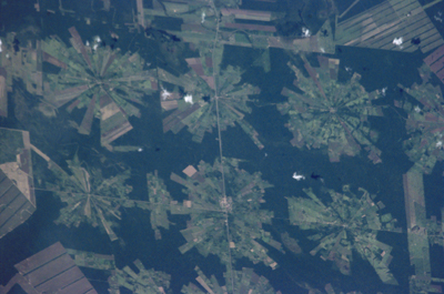
Tierras Bajas Deforestation, BoliviaThis digital photograph of deforestation associated with the Tierras Bajas project in eastern Bolivia was taken by astronauts from the International Space Station on April 16, 2001. The spatial resolution of the original digital photograph is about 6 meters per pixel.
The area east of Santa Cruz was originally dry tropical forest. As part of the Tierras Bajas project, people have been resettled from the Altiplano to cultivate soybeans. Each agricultural "pin wheel" pattern is centered on a small community. The communities are then spaced evenly across the landscape at 5-km intervals. Roadways can be seen connecting each town center.
See previous images of this area posted to Earth Observatory:
Landsat & aerial photography
Landsat time series
Download Packaged File.
This option downloads the following items, packaged into a single file, if they are available:
- Browse image
- Cataloged information with captions
- Camera file
- Sound file
Server: 2 |
This service is provided by the International Space Station program. |
Recommended Citation: |
||

