| Home >> | Advanced Search >> |
 |
|
Astronaut Photography of Earth - Display Record
ISS002-E-5325

Low-resolution Browse Image
(Most browse images are not color adjusted.)Images
Conditions for Use of Images >>Image Transformation Tutorial >> Saving, Color Adjusting, and Printing Images >>
Images to View on Your Computer Now
| File Name | File Size (bytes) | Width | Height | Annotated | Cropped | Purpose | Comments | |
|---|---|---|---|---|---|---|---|---|
| View | ISS002-E-5325.JPG | 84241 | 540 | 540 | Yes | Yes | NASA's Earth Observatory web site | |
| View | ISS002-E-5325.JPG | 92498 | 640 | 437 | No | No | ||
| View | ISS002-E-5325_3.JPG | 136060 | 400 | 273 | No | No | Photographic Highlights | |
| View | ISS002-E-5325.JPG | 150846 | 540 | 369 | Photographic Highlights | (540px resized images) | ||
| View | ISS002-E-5325.JPG | 230840 | 1200 | 820 | No | No | Cities collection | |
| View | ISS002-E-5325.JPG | 1438928 | 3060 | 2092 | No | No | NASA's Earth Observatory web site | |
| View | ISS002-E-5325.JPG | 1536272 | 3060 | 2092 | No | No | Cities collection |
Large Images to Request for Downloading
| File Name | File Size (bytes) | Width | Height | Annotated | Cropped | Purpose | Comments | |
|---|---|---|---|---|---|---|---|---|
| Request | ISS002-E-5325.JPG | 436858 | 1024 | 700 | Photographic Highlights | actual files used | ||
| Request | ISS002-E-5325.JPG | 1438928 | 3060 | 2092 | No | No | NASA's Earth Observatory web site | |
| Request | ISS002-E-5325.JPG | 1660827 | 3060 | 2092 | No | No |
Download a Keyhole Markup Language (KML) file for use in Google Earth.
Electronic Image Data
Camera Files >> No sound file available.Identification
Mission: ISS002 Roll: E Frame: 5325 Mission ID on the Film or image: ISS002Country or Geographic Name: USA-NEW YORK
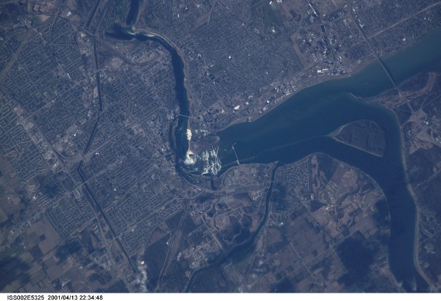
Features: NIAGARA FALLS
Center Point Latitude: 43.0 Center Point Longitude: -79.0 (Negative numbers indicate south for latitude and west for longitude)
Stereo: (Yes indicates there is an adjacent picture of the same area)
ONC Map ID: JNC Map ID:
Camera
Camera Tilt: 19Camera Focal Length: 800mm
Camera: E2: Kodak DCS460 Electronic Still Camera
Film: 3060E : 3060 x 2036 pixel CCD, RGBG array.
Quality
Film Exposure:Percentage of Cloud Cover: 10 (0-10)
Nadir
Date: 20010413 (YYYYMMDD)GMT Time: 222048 (HHMMSS)Nadir Point Latitude: 42.0, Longitude: -79.6 (Negative numbers indicate south for latitude and west for longitude)
Nadir to Photo Center Direction: Northeast
Sun Azimuth: 267 (Clockwise angle in degrees from north to the sun measured at the nadir point)
Spacecraft Altitude: 209 nautical miles (387 km)
Sun Elevation Angle: 17 (Angle in degrees between the horizon and the sun, measured at the nadir point)
Orbit Number: 1706
Captions
Mark Twain once said of Niagara Falls: "Although it was wonderful to see all that water tumbling down, it would be even more wonderful to see all that water tumbling up."Viewing the tumbling waters of the Niagara River from the microgravity environment of the International Space Station, astronauts recently acquired this image. They were at an orbit of 207 nautical miles (383 km) above the Falls, and used a digital camera with an 800 mm lens. In taking these kinds of detailed images, Space Station crewmembers have compensated for the relative motion of the Earth, thus achieving spatial resolutions of less than 6 m and surpassing the previous records for spatial resolution from human spaceflight. Details of the city of Niagara Falls are easy to see; for spatial reference, the American falls is 328 m wide (1075 ft), and the Horseshoe Falls is 675 m wide (2200 ft).
The Niagara River forms the U.S.-Canadian Border and allows Lake Erie to drain northwest into Lake Ontario. Lake Ontario is about 100 m lower than Lake Erie; the Falls and the rapids account for most of the elevation difference. The energy derived from water falling over the falls, with average total flows of 750,000 U.S. gallons (2.8 million liters) per second, fuel multiple power plants on the river. Power Plants downstream from the plant generate 4.4 million kilowatts of power for both Ontario and New York.
Download Packaged File.
This option downloads the following items, packaged into a single file, if they are available:
- Browse image
- Cataloged information with captions
- Camera file
- Sound file
Server: 2 |
This service is provided by the International Space Station program. |
Recommended Citation: |
||

