| Home >> | Advanced Search >> |
 |
|
Astronaut Photography of Earth - Display Record
STS111-376-3

Low-resolution Browse Image
(Most browse images are not color adjusted.)Images
Conditions for Use of Images >>Image Transformation Tutorial >> Saving, Color Adjusting, and Printing Images >>
Images to View on Your Computer Now
| File Name | File Size (bytes) | Width | Height | Annotated | Cropped | Purpose | Comments | |
|---|---|---|---|---|---|---|---|---|
| View | STS111-376-3.JPG | 25744 | 515 | 342 | No | No | From ISD highres, sharpened | |
| View | STS111-376-3.JPG | 75350 | 540 | 383 | Yes | Yes | NASA's Earth Observatory web site | |
| View | STS111-376-3.JPG | 296622 | 540 | 405 | Photographic Highlights | (540px resized images) | ||
| View | STS111-376-3.JPG | 1397578 | 1402 | 995 | No | Yes | NASA's Earth Observatory web site |
Large Images to Request for Downloading
| File Name | File Size (bytes) | Width | Height | Annotated | Cropped | Purpose | Comments | |
|---|---|---|---|---|---|---|---|---|
| Request | STS111-376-3.JPG | 466322 | 3070 | 2044 | No | No | Photographic Highlights | From ISD TGA images |
| Request | STS111-376-3.JPG | 466322 | 3070 | 2044 | No | No | From ISD TGA images | |
| Request | STS111-376-3_2.JPG | 828640 | 1024 | 768 | Photographic Highlights | (actual files used) | ||
| Request | STS111-376-3.TIF | 2876263 | 1200 | 798 | No | No | Photographic Highlights | From ISD TGA images |
Download a Keyhole Markup Language (KML) file for use in Google Earth.
Electronic Image Data
Camera files only apply to electronic still cameras.No sound file available.
Identification
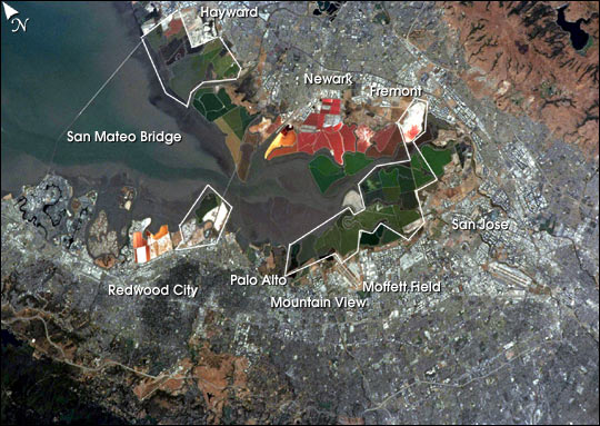
Mission: STS111 Roll: 376 Frame: 3 Mission ID on the Film or image: STS111Country or Geographic Name: USA-CALIFORNIA
Features: SAN JOSE AREA, SALT PONDS
Center Point Latitude: 37.5 Center Point Longitude: -122.0 (Negative numbers indicate south for latitude and west for longitude)
Stereo: (Yes indicates there is an adjacent picture of the same area)
ONC Map ID: JNC Map ID:
Camera
Camera Tilt: 45Camera Focal Length: mm
Camera: NK: Nikon 35mm film camera
Film: 5069 : Kodak Elite 100S, E6 Reversal, Replaces Lumiere, Warmer in tone vs. Lumiere.
Quality
Film Exposure:Percentage of Cloud Cover: 10 (0-10)
Nadir
Date: 20020617 (YYYYMMDD)GMT Time: 195341 (HHMMSS)Nadir Point Latitude: 36.5, Longitude: -119.1 (Negative numbers indicate south for latitude and west for longitude)
Nadir to Photo Center Direction: West
Sun Azimuth: 176 (Clockwise angle in degrees from north to the sun measured at the nadir point)
Spacecraft Altitude: 187 nautical miles (346 km)
Sun Elevation Angle: 77 (Angle in degrees between the horizon and the sun, measured at the nadir point)
Orbit Number: 188
Captions
The red and green colors of the salt ponds in South San Francisco Bay are brilliant visual markers for astronauts. The STS-111 crew photographed the bay south of the San Mateo bridge in June, 2002. This photograph is timely because a large number of the salt ponds (more than 16,500 acres) that are owned by Cargill, Inc. will be sold in September for wetlands restoration—a restoration project second in size only to the Florida Everglades project. Rough boundaries of the areas to be restored are outlined on the image.Over the past century, more than 80% of San Francisco Bay’s wetlands have been filled and developed or diked off for salt mining. San Francisco Bay has supported salt mining since 1854. Cargill has operated most of the bay’s commercial salt ponds since 1978, and had already sold thousands of acres to the State of California and the Don Edwards National Wildlife Refuge. This new transaction will increase San Francisco Bay’s existing tidal wetlands by 50%. The new wetlands, to be managed by the California Department of Fish and Game and the U.S. Fish and Wildlife Service, will join the Don Edwards National Wildlife Refuge, and provide valuable habitat for birds, fish and other wildlife. The wetlands will contribute to better water quality and flood control in the bay, and open up more coastline for public enjoyment.
Additional information:
Historic Agreement Reached to Purchase San Francisco Bay Salt Ponds
Download Packaged File.
This option downloads the following items, packaged into a single file, if they are available:
- Browse image
- Cataloged information with captions
- Camera file
- Sound file
Server: 2 |
This service is provided by the International Space Station program. |
Recommended Citation: |
||

