
Images & Animations
-
Credit
Jacques Descloitres, MODIS Land Rapid Response Team, NASA/GSFC
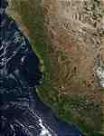
This true-color image of western Mexico was acquired from data collected on October 30, 2001. In the upper-right portion of the image are the Sierra Madre Occidental mountains as they pass through the central region of Mexico. Running parallel to the western coastline of Mexico, the Sierra Madre Occidental spans 700 miles, and is one of the 3 mountain chains that comprise the Sierra Madres, the principal mountain system in Mexico.
Lake Chapala, Mexico's largest natural lake, shows up as the lower of two gray areas just below the image's center. The lake serves many functions that include being used for irrigation, recreation, an industrial waste receptacle, and as a water supply for the city of Guadalajara, which is the gray patch to its north.
Metadata
-
Sensor
Terra/MODIS -
Visualization Date
2001-10-30