GEOS-5 Model Run Showing Hurricane Katrina
|
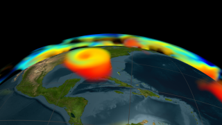
This visualization shows data from a global atmospheric assimilation model for August 2005. In early August the camera looks towards the North pole showing the swirling winds caused by the Coriolis effect; then the camera moves down towards Africa which is the birthplace of many tropical storms; finally, the camera moves across the Atlantic as many of the storms form during 2005 ending with Hurricane Katrina. This visualization was created in support of demonstrations given at the Supercomputing 2007 Conference.
|
|
|
|
GEOS-5 model run during August 2005
Duration: 32.0 seconds
Available formats:
1280x720 (30 fps)
MPEG-4
15 MB
640x360 (30 fps)
MPEG-4
6 MB
512x288 (30 fps)
MPEG-1
9 MB
1280x720 (30 fps)
MPEG-2
37 MB
1280x720 (30 fps)
Frames
320x180
PNG
177 KB
160x80
PNG
44 KB
80x40
PNG
11 KB
How to play our movies
|
|
|
Back to Top
|

