Event CategoriesYear 2008 Storm Events
Year 2007 Storm Events
Year 2006 Storm Events
Year 2005 Storm Events
Year 2004 Storm Events
Year 2003 Storm Events
Year 2002 Storm Events
Year 2001 Storm Events
Year 2000 Storm Events
Archival Imagery
2008 Regional Imagery
2007 Regional Imagery
2006 Regional Imagery
2005 Regional Imagery
2004 Regional Imagery
2003 Regional Imagery
2002 Regional Imagery
2001 Regional Imagery
2001 Regional Analyses
2000 Regional Imagery
2000 Regional Analyses
1999 Tropical Storm Summary
Home
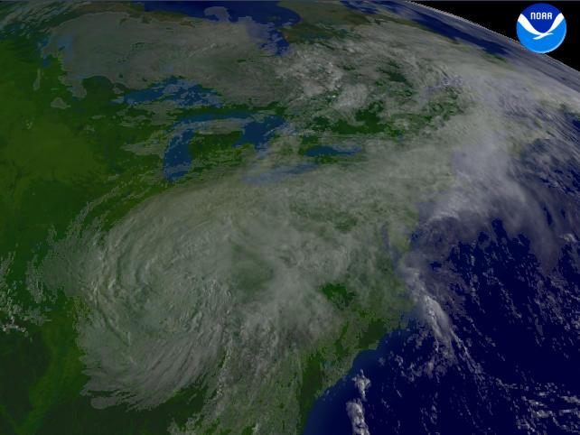
NOAA Satellite and Information Service Home Page NOAA's All Hazards Monitor Where in the World is Tomorrow Now? NOAA National Hurricane Center NOAA Satellite Services Division Geostationary Satellite Server nowCOAST GIS Mapping Portal to Real-Time Environmental Observations and NOAA Forecasts Operational Significant Event Imagery Defense Meteorological Satellite Program NCDC Climate of 2008 FAQ: Hurricanes, Typhoons And Tropical Cyclones Visualization Lab Support | Year 2005 Storm EventsTropical Storm KatrinaTropical Storm Katrina regional imagery, 2005.08.30 at 1315Z.
Centerpoint Latitude: 34:47:36N Longitude: 88:38:54W.
View our smaller 640 X 480
picture!Data Elements: Tropical Storm Katrina is currently located northeast of Tupelo, Mississippi. See this higher resolution image of Tropical Storm Katrina.
Observation Device: GOES-12 1 km visible imagery.
Visualization Date: August 30, 2005 10:08:10
|


