
 Feeds & Data
Magnitude 6.7 - BOUGAINVILLE REGION, PAPUA NEW GUINEA
2007 June 28 02:52:09 UTC
Earthquake Details
| Magnitude | 6.7 |
|---|---|
| Date-Time |
|
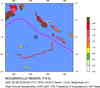
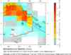
| Location | 7.938°S, 154.616°E |
| Depth | 10 km (6.2 miles) set by location program |
| Region | BOUGAINVILLE REGION, PAPUA NEW GUINEA |
| Distances | 220 km (135 miles) SSW of Arawa, Bougainville, PNG 240 km (150 miles) ENE of Kulumadau, Woodlark Island, PNG 825 km (520 miles) E of PORT MORESBY, Papua New Guinea 2160 km (1350 miles) N of BRISBANE, Queensland, Australia |
| Location Uncertainty | horizontal +/- 4 km (2.5 miles); depth fixed by location program |
| Parameters | NST=238, Nph=238, Dmin=609.3 km, Rmss=0.78 sec, Gp= 22°, M-type=teleseismic moment magnitude (Mw), Version=S |
| Source |
|
| Event ID | us2007edaf |
- This event has been reviewed by a seismologist.
- Did you feel it? Report shaking and damage at your location. You can also view a map displaying accumulated data from your report and others.
Earthquake Summary


The following is a release by the United States Geological Survey, National Earthquake Information Center: An earthquake occurred about 220 km (135 miles) SSW of Arawa, Bougainville, PNG or about 825 km (520 miles) E of PORT MORESBY, Papua New Guinea at 8:52 PM MDT, Jun 27, 2007 (Jun 28 at 12:52 PM local time in Papua New Guinea). The magnitude and location may be revised when additional data and further analysis results are available. There have been no reports of damage.
 Tsunami Information
- West Coast & Alaska Tsunami Warning Center
- Pacific Tsunami Warning Center
- NOAA Tsunami Warning Center
- Recent Tsunamis
- Tsunami Information Links
The earthquake locations and magnitudes cited in these bulletins are very preliminary, and may disagree with the more accurate USGS locations and magnitudes computed using more extensive data sets.
Earthquake Maps


Scientific & Technical Information

- Preliminary Earthquake Report
- U.S. Geological Survey, National Earthquake Information Center:
World Data Center for Seismology, Denver
