Local forecast by
"City, St" or zip code |
Search by city or zip code. Press enter or select the go button to submit request |
|
The National Weather Service in Birmingham has responsibility for
providing meteorological support to land management agencies for wildfires
and prescribed burns across central Alabama. This support is primarily
achieved through the issuance of a Fire
Weather Forecast.
Fire Weather Forecasts are issued by the Birmingham office twice a
day, by 7:30 am and 3:00 pm (CST/CDT). If a more detailed forecast
is needed, land management agencies may request a Spot Forecast by
clicking on the links above.
|
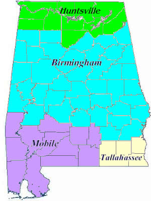
The shaded areas on the map represent the fire weather forecast
areas and which office has responsibility.
Click on the shaded area to view the fire weather forecast for that area.
|
Most of the terminology used in the fire weather forecast is typical
of what you would hear in any weather forecast. However, there are
certain terms which are used mainly within the forestry program and
are discussed below.
Mixing Height
- Definition: The height of the vertical mixing of the air and suspended particles above the ground.
- Purpose: To determine how far smoke will rise.
- How it is calculated: A temperature profile of the atmosphere is determined from data taken from weather balloons released twice a day all across the United States. By plotting the data on a
special temperature-pressure map, a temperature curve is created from the surface of the earth up through 25,000 feet. A parcel of air rising from the surface of the earth will rise at a given rate
(called the dry-adiabatic lapse rate). As long as the parcel of air is warmer than the temperature curve, it will continue to rise. However, once it becomes colder than the temperature curve, it will
slow down and eventually stop. It is at this junction where it crosses the temperature curve that determines the mixing height.
Transport Wind
- Definition: The average wind speed and direction in the mixed layer above the surface of the earth.
- Purpose: To determine how quickly smoke will disperse horizontally.
- How it is calculated: If the mixing height is 3500 feet, then all wind speed and direction data from the surface of the earth through 3500 feet is averaged together to give a transport wind.
Dispersion Index
- Definition: A numerical index that estimates the atmosphere's capacity to disperse smoke.
- Purpose: To assist user agencies in smoke management.
- How it is calculated: There is no one formula to calculate this index but a series of calculations. The index includes variables such as cloud cover, surface wind speed, mixing height and
transport wind. Generally, the stronger the transport wind, the higher the index.
- Higher numbers indicate better dispersion.
Scale Interpretation
| 1-6 |
Very poor dispersion |
| 7-12 |
Poor dispersion |
| 13-20 |
Generally poor dispersion |
| 21-40 |
Fair dispersion |
| 41-60 |
Generally good dispersion |
| 61-100 |
Good dispersion |
| 100+ |
Very good dispersion |
|
|
|
National Weather Service
Birmingham, Alabama Weather Forecast Office
465 Weathervane Road
Calera, Alabama 35040
Phone: (205) 664-3010
Contact Us
Page last modified: June
26,
2003
|
Disclaimer |
Privacy Policy |
|