
 Feeds & Data
Magnitude 5.9 - TANZANIA
2007 July 17 14:10:42 UTC
Earthquake Details
| Magnitude | 5.9 |
|---|---|
| Date-Time |
|
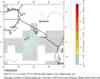
| Location | 2.586°S, 36.281°E |
| Depth | 8 km (5.0 miles) set by location program |
| Region | TANZANIA |
| Distances | 80 km (50 miles) NNW of Arusha, Tanzania 170 km (105 miles) SSW of NAIROBI, Kenya 275 km (170 miles) S of Nakuru, Kenya 560 km (345 miles) NW of DAR ES SALAAM, Tanzania |
| Location Uncertainty | horizontal +/- 10.1 km (6.3 miles); depth fixed by location program |
| Parameters | NST=100, Nph=100, Dmin=194 km, Rmss=0.97 sec, Gp= 65°, M-type=moment magnitude (Mw), Version=V |
| Source |
|
| Event ID | us2007exbe |
- This event has been reviewed by a seismologist.
- Did you feel it? Report shaking and damage at your location. You can also view a map displaying accumulated data from your report and others.
Earthquake Summary


Felt Reports
Some damage (IV) at Arusha and felt (V) at Moshi. Felt at Kingori, Longido, Mwanza, Ngara, Tanga and Usa River. Felt (IV) at Kijabe, Mombasa, Nairobi, Naivasha and Voi, Kenya. Also felt at Kisumu and Namanga, Kenya; Kigali, Rwanda; Kampala, Uganda.
Tectonic Summary
The sequence of earthquakes that has been occurring in northern Tanzania since July 14, 2007, represents a seismic phenomenon known as a seismic "swarm"-- an episode of high earthquake activity in which the largest earthquake does not occur at the beginning of the episode and in which the largest earthquake is not substantially larger than other earthquakes of the episode. Worldwide, earthquake swarm activity is commonly associated with tectonic regions in which both strike-slip fault and normal faulting occur and where magmatic activity occurs at shallow depths in the earth's crust.
The earthquake swarm is situated close to the Ol Doinyo Lengai volcano, an active volcano in the Gregory Rift of the East African rift system. Although volcanic eruptions are often preceded and accompanied by earthquake swarms, most earthquake swarms are not associated with volcanic eruptions. Information recorded at the U. S. Geological Survey/National Earthquake Information Center is not sufficient to determine if the current Tanzania swarm activity reflects a geologic process that might lead to a change in the eruptive behavior of Ol Doinyo Lengai.
The East African rift system is a diffuse zone of crustal extension that passes through eastern Africa from Djibouti and Eritrea on the north to Malawi and Mozambique on the south and that constitutes the boundary between the Africa plate on the west and the Somalia plate on the east. At the earthquake?s latitude, the Africa and Somalia plates are spreading apart at a rate of several millimeters per year. The largest earthquake to have occurred in the rift system since 1900 had a magnitude of about 7.6. Earthquakes within the East African rift system occur as the result of both normal faulting and strike-slip faulting.
Earthquake Maps


Scientific & Technical Information

- Preliminary Earthquake Report
- U.S. Geological Survey, National Earthquake Information Center:
World Data Center for Seismology, Denver
