
 Feeds & Data
Magnitude 7.1 - MACQUARIE ISLAND REGION
2008 April 12 00:30:11 UTC
Earthquake Details
| Magnitude | 7.1 |
|---|---|
| Date-Time |
|
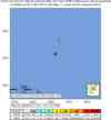
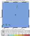
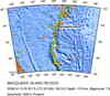
| Location | 55.681°S, 158.527°E |
| Depth | 10 km (6.2 miles) set by location program |
| Region | MACQUARIE ISLAND REGION |
| Distances | 120 km (75 miles) SSW of Macquarie Island, Australia 760 km (470 miles) SW of Auckland Island, New Zealand 1995 km (1240 miles) SSW of WELLINGTON, New Zealand 2370 km (1470 miles) SSE of CANBERRA, A.C.T., Australia |
| Location Uncertainty | horizontal +/- 8.2 km (5.1 miles); depth fixed by location program |
| Parameters | NST=207, Nph=207, Dmin=>999 km, Rmss=1.05 sec, Gp= 58°, M-type=moment magnitude (Mw), Version=8 |
| Source |
|
| Event ID | us2008qtae |
- This event has been reviewed by a seismologist.
- Did you feel it? Report shaking and damage at your location. You can also view a map displaying accumulated data from your report and others.
Earthquake Summary


The following is a release by the United States Geological Survey, National Earthquake Information Center: An earthquake occurred 110 km (70 miles) SSW of Macquarie Island, Australia. 755 km (470 miles) SW of Auckland Island, New Zealand 1995 km (1240 miles) SSW of WELLINGTON, New Zealand at 5:30 PM MST, Apr 11, 2008 (Apr 12 at 11:30 AM local time in New Zealand). The magnitude and location may be revised when additional data and further analysis results are available. There have been no reports of damage at this time.
Tectonic Summary
The April 12th, 2008 earthquake south of the Macquarie Islands indicates thrust faulting on the plate boundary between the Australian and Pacific Plates in the southwest Pacific Ocean. The earthquake is located in a region of rapid transitions in plate motion from convergence at the Hjort Trench (just south of the earthquake) to strike-slip motion along the Macquarie Ridge (north of the earthquake), brought about by the close proximity of this section of the plate boundary to the Australia:Pacific pole of rotation. This plate boundary transition is delineated by earthquakes of both thrust and strike-slip orientation in the vicinity of the 04/12/2008 earthquake. In the epicentral region of this event, the Australian Plate moves north-northeast with respect to the Pacific Plate at a rate of approximately 27 mm/yr.
The Australia-Pacific plate boundary south of New Zealand experiences numerous strong earthquakes, and has hosted great (M8+) earthquakes in recent history. In 1989, a magnitude 8.1 earthquake occurred on the plate boundary approximately 380km north of the 04/12/2008 event, and most recently a magnitude 8.1 event occurred within the Australian Plate west of the plate boundary another 250 km further north. The 04/12/2008 event is the largest known historic earthquake on the section of the plate boundary south of the 1989 event since a nearby magnitude 8.3 earthquake in 1924.
Earthquake Maps


Scientific & Technical Information

- Preliminary Earthquake Report
- U.S. Geological Survey, National Earthquake Information Center:
World Data Center for Seismology, Denver
