

National Climatic Data Center
16 September 2008
The data presented in this report are preliminary. Ranks and anomalies may change as more complete data are received and processed. The most current data may be accessed via the Global Surface Temperature Anomalies page.
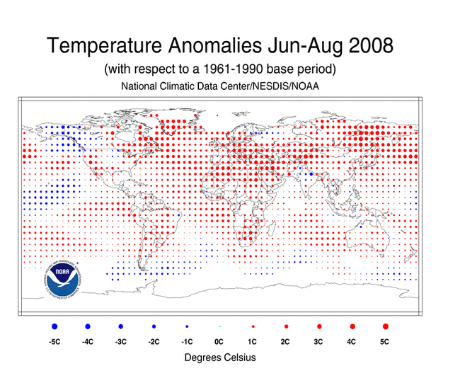
Temperature anomalies for June-August 2008 and August 2008 are shown on the dot maps below. The dot maps, below left, provide a spatial representation of anomalies calculated from the Global Historical Climatology Network (GHCN) data set of land surface stations using a 1961-1990 base period. The dot maps, below right, are a product of a merged land surface and sea surface temperature anomaly analysis developed by Smith and Reynolds (2005). Temperature anomalies with respect to the 1961-1990 mean for land and ocean are analyzed separately and then merged to form the global analysis. Additional information on this product is available.
During August, above-average temperatures were observed across the British Isles, the western continental U.S., parts of Russia and Africa, and most of Europe and South America. Meanwhile, cooler-than-average conditions were present across Australia, Mongolia, parts of the central and eastern contiguous U.S., and southern Argentina. According to Australia's Bureau of Meteorology (BoM), Western Australia recorded an all-time minimum temperature on August 17 when temperatures dropped to -7.2°C (19.0°F) in Eyre, located on the Nullarbor coast. The second all-time minimum temperature for the state was -6.7°C (19.9°F) set on 12 July 1969, while the second August minimum temperature for Western Australia was -6.1°C (21.0°F) set on 15 August 1970. A complete summary is available courtesy of Australia's BoM.
August sea surface temperatures (SSTs) were warmer than average in the Atlantic, Indian, and parts of the northwestern and eastern equatorial Pacific oceans. Cooler-than-average conditions were present in parts of the southern oceans, the central equatorial Pacific, and parts of the northeastern Pacific oceans.
During the boreal summer, temperatures were above average in most of the contiguous U.S., Mexico, Europe, Australia, the British Isles, Asia, and South America. Cooler-than-average conditions occurred across the western and southern coast of Alaska, parts of northern Scandinavia and northwestern Russia.
Anomalously warm temperatures covered much of the global land during the first eight months of the year. January-August 2008 had cooler-than-average temperatures across eastern Australia and parts of the north-central and western contiguous U.S. The year-to-date map of temperature anomalies shows the presence of warmer-than-average temperatures across Mexico, Europe, Asia, central and western Australia, the northeastern and southern continental U.S., most of Africa and South America. The sea surface temperatures (SSTs) were warmer than average across the Atlantic, western North Pacific, and most of the Indian oceans. Cooler-than-average SSTs were present across the central equatorial Pacific Ocean and along the western coast of North America and most of the southern oceans.
The mean position of the upper-level ridges of high pressure and troughs of low pressure (depicted by positive and negative 500-millibar height anomalies on the June-August 2008 map and the August map) are generally reflected by areas of positive and negative temperature anomalies at the surface, respectively. For other Global products see the Climate Monitoring Global Products page.
Images of sea surface temperature conditions are available for all weeks during 2008 at the weekly SST page.
Current Month / Seasonal / Year-to-date
Effective with the February 2006 report, NCDC transitioned from the use of the Operational Global Surface Temperature Index (Quayle et al. 1999) to the blended land and ocean dataset developed by Smith and Reynolds (2005). The differences between the two methods are discussed in Smith et al. (2005).
The 2008 combined global land and ocean surface temperature tied with 1995 as the tenth warmest August on record, while the 2008 boreal summer (June-August) and the January-August year-to-date ranked as the ninth warmest on record.
| August | Anomaly | Rank (out of 129 years) |
Warmest (or Next Warmest) Year on Record |
|---|---|---|---|
GlobalLandOcean Land and Ocean |
+0.49°C (+0.88°F) +0.43°C (+0.77°F) +0.44°C (+0.79°F) |
11th warmest 7th warmest 10th warmest |
1998 (+0.92°C/1.66°F) 1998 (+0.54°C/0.97°F) 1998 (+0.64°C/1.15°F) |
Northern HemisphereLandOcean Land and Ocean |
+0.54°C (+0.97°F) +0.47°C (+0.85°F) +0.50°C (+0.90°F) |
10th warmest 7th warmest 8th warmest |
2007 (+1.01°C/1.82°F) 2005 (+0.65°C/1.17°F) 2003 (+0.72°C/1.30°F) |
Southern HemisphereLandOcean Land and Ocean |
+0.34°C (+0.61°F) +0.39°C (+0.70°F) +0.38°C (+0.68°F) |
19th warmest 6th warmest 8th warmest |
1998 (+0.87°C/1.57°F) 1998 (+0.51°C/0.92°F) 1998 (+0.57°C/1.03°F) |
| June-August | Anomaly | Rank (out of 129 years) |
Warmest (or Next Warmest) Year on Record |
|---|---|---|---|
GlobalLandOcean Land and Ocean |
+0.62°C (+1.12°F) +0.41°C (+0.74°F) +0.47°C (+0.85°F) |
7th warmest 9th warmest 9th warmest |
1998 (+0.90°C/1.62°F) 1998 (+0.54°C/0.97°F) 1998 (+0.64°C/1.15°F) |
Northern HemisphereLandOcean Land and Ocean |
+0.66°C (+1.19°F) +0.48°C (+0.86°F) +0.55°C (+0.99°F) |
7th warmest 7th warmest 8th warmest |
1998 (+0.93°C/1.67°F) 2005 (+0.64°C/1.15°F) 2005 (+0.72°C/1.30°F) |
Southern HemisphereLandOcean Land and Ocean |
+0.48°C (+0.86°F) +0.37°C (+0.67°F) +0.38°C (+0.68°F) |
10th warmest 9th warmest 9th warmest |
2005 (+0.88°C/1.58°F) 1998 (+0.53°C/0.95°F) 1998 (+0.58°C/1.04°F) |
| January-August | Anomaly | Rank (out of 129 years) |
Warmest (or Next Warmest) Year on Record |
|---|---|---|---|
GlobalLandOcean Land and Ocean |
+0.72°C (+1.30°F) +0.35°C (+0.63°F) +0.45°C (+0.81°F) |
8th warmest 10th warmest 9th warmest |
2007 (+1.04°C/1.87°F) 1998 (+0.53°C/0.95°F) 1998 (+0.64°C/1.15°F) |
Northern HemisphereLandOcean Land and Ocean |
+0.82°C (+1.48°F) +0.37°C (+0.67°F) +0.54°C (+0.97°F) |
7th warmest 8th warmest 9th warmest |
2007 (+1.23°C/2.21°F) 2005 (+0.54°C/0.97°F) 2007 (+0.74°C/1.33°F) |
Southern HemisphereLandOcean Land and Ocean |
+0.41°C (+0.74°F) +0.33°C (+0.59°F) +0.34°C (+0.61°F) |
12th warmest 16th warmest 15th warmest |
2005 (+0.89°C/1.60°F) 1998 (+0.55°C/0.99°F) 1998 (+0.60°C/1.08°F) |
The most current data may be accessed via the Global Surface Temperature Anomalies page.
The maps below represent anomaly values based on the GHCN data set of land surface stations using a base period of 1961-1990. During the boreal summer (June-August), above-average precipitation fell over areas that included the British Isles, the Alaska panhandle, across the Caribbean, and parts of India, Europe, the central and eastern continental U.S., central Russia, and eastern Asia. Drier-than-average conditions were observed in the Hawaiian Islands, most of the western contiguous U.S., southern Australia, parts of the western Pacific Islands, South America, Europe, and East Asia.
During August 2008, above-average precipitation fell over areas that included the British Isles, the central and southeastern contiguous U.S., and parts of Europe, India, central Russia, eastern Asia, South America, and the Caribbean. Drier-than-average conditions were observed across the midwestern U.S., western Alaska, Hawaiian Islands, the western Pacific Islands, and parts of Australia, southern Europe, eastern Asia, and South America.
According to Australia's Bureau of Meteorology (BoM), precipitation across Australia was 43 percent below the 1961-1990 normal during August, resulting in the 14th driest August since records began in 1900. The southwestern region in the State of Western Australia experienced its driest August on record with 77 percent below normal precipitation. During June-August, Australia as a whole experienced 11 percent below-normal precipitation, resulting in the 41st driest austral winter over the 109-year historical period.
According to the UK Met Office, unsettled weather affected the British Isles during the boreal summer, prompting the total summer rainfall (1 June - 26 August 2008) to be much above the 1971-2000 mean. As of 29 August 2008, the UK and the countries that constitute the UK, the June-August 2008 period ranked as one of the top 10 wettest summers since records began in 1914. Northern Ireland experienced its second wettest boreal summer when a total of 393.7 mm (15.5 inches) of rain fell. The wettest boreal summer for Northern Ireland was set in 1958 when 404.0 mm (15.9 inches) of rain fell. A complete summary is available courtesy of the UK Met Office.
Intense monsoonal downpours pummeled northern India during August. Flash floods claimed the lives of 74 people and left nearly 50,000 people homeless. Varanasi, India received a total of 292.1 mm (11.5 inches) of rain in 24 hours.
Three Atlantic and two northwestern Pacific tropical cyclones developed and made landfall in August. Tropical Storm Edouard began the month, forming on August 3 and making landfall near Port Arthur, TX on August 5. The storm brought much needed precipitation across the southern U.S. Tropical Storm Kammuri developed on the 4th and made landfall in southern China on the 6th. Kammuri dumped heavy rain and triggered floods and landslides across Hong Kong and northern Vietnam. A total of 120 fatalities were attributed to the storm. Tropical Storm Fay formed on August 15 and made an initial landfall at Key West, FL on August 18. Over the next 6 days, Fay became the first storm on record to make four separate landfalls in one state (Florida). Extensive flooding was reported in parts of Florida due to heavy rains from Tropical Storm Fay.
Typhoon Nuri formed on the 18th, making its first landfall in the Philippine Islands on the 20th and a second landfall in Hong Kong on the 22nd. The storm was blamed for 7 fatalities across the Philippines and three deaths in Hong Kong. Hurricane Gustav pounded several Caribbean nations before making landfall west of Grand Isle, LA on September 1 as a Category 3 storm. Gustav claimed an estimated 120 lives, including 25 in the U.S., and resulted in an estimated several billion dollars in damage.
Additional details on flooding and drought can also be found on the August Global Hazards page.
Sea surface temperatures (SST) were above average across the eastern and western equatorial Pacific Ocean during August while slightly below or near average temperatures were observed across the central equatorial Pacific. These conditions are indicative of a neutral ENSO phase (as shown in the adjacent animation of weekly SST anomalies). A comprehensive summary of August 2008 ENSO conditions can be found on the ENSO monitoring page. For the latest advisory on ENSO conditions go to NOAA's Climate Prediction Center (CPC) and the CPC ENSO Diagnostic Discussion.
Images of sea surface temperature conditions are available for all weeks since 2003 at the weekly SST page.
According to the National Snow and Ice Data Center, the August 2008 Northern Hemisphere sea ice extent, which is measured from passive microwave instruments onboard NOAA satellites, was below the 1979-2000 mean. This was the second least August sea ice extent (21.4 percent below the 1979-2000 mean) since records began in 1979, behind 2007. Sea ice extent for August has decreased at a record rate of 8.7 percent per decade since satellite records began in 1979.
Meanwhile, the August 2008 Southern Hemisphere sea ice extent was the sixth least August sea ice extent (0.79 percent below the 1979-2000 mean) over the 30-year historical period. Sea ice extent for August has increased at a rate of 0.2 percent per decade.
For further information on the Northern and Southern Hemisphere snow and ice conditions, please visit the NSIDC News page, provided by the NOAA's National Snow and Ice Data Center (NSIDC).
Temperatures above the Earth's surface are measured within the lower Troposphere, middle Troposphere, and Stratosphere using in-situ balloon-borne instruments (radiosondes) and polar-orbiting satellites (NOAA's TIROS-N). The radiosonde and satellite records have been adjusted to remove time-dependent biases (inhomogeneities caused by changes in radiosonde instruments and measurement practices as well as changes in satellite instruments and orbital features through time).
Current Month / Seasonal / Year-to-date
These temperatures are for the lowest 8 km (5 miles) of the atmosphere. Information on the UAH and RSS sources of troposphere data is available.
| August | Anomaly | Rank (out of 30 years) |
Warmest [Coolest] (or Next Warmest [Coolest]) Year on Record | Trend |
|---|---|---|---|---|
| UAH low-trop | -0.01°C/-0.02°F | 19th warmest (12th coolest) |
1998 (+0.51°C/0.92°F) [1992 (-0.39°C/-0.70°F)] |
+0.11°C/decade |
| *RSS low-trop | +0.15°C/0.26°F | 11th warmest (20th coolest) |
1998 (+0.61°C/1.10°F) [1992 (-0.35°C/-0.63°F)] |
+0.17°C/decade |
*Version 03_0
| June- August |
Anomaly | Rank (out of 30 years) |
Warmest [Coolest] (or Next Warmest [Coolest]) Year on Record | Trend |
|---|---|---|---|---|
| UAH low-trop | -0.02°C/-0.04°F | 20th warmest (11th coolest) |
1998 (+0.53°C/0.96°F) [1992 (-0.30°C/-0.54°F)] |
+0.10°C/decade |
| *RSS low-trop | +0.11°C/0.20°F | 12th warmest (19th coolest) |
1998 (+0.61°C/1.10°F) [1985 (-0.34°C/-0.61°F)] |
+0.16°C/decade |
*Version 03_0
| January- August |
Anomaly | Rank (out of 30 years) |
Warmest [Coolest] (or Next Warmest [Coolest]) Year on Record | Trend |
|---|---|---|---|---|
| UAH low-trop | -0.02°C/-0.04°F | 20th warmest (11th coolest) |
1998 (+0.61°C/1.10°F) [1985 (-0.22°C/-0.40°F)] |
+0.12°C/decade |
| *RSS low-trop | 0.04°C/0.07°F | 18th warmest (13th coolest) |
1998 (+0.67°C/1.21°F) [1985 (-0.31°C/-0.56°F)] |
+0.17°C/decade |
*Version 03_0
Current Month / Seasonal / Year-to-date
These temperatures are for the atmospheric layer centered in the mid-troposphere (approximately 3-10 km (2-6 miles) above the Earth's surface), which also includes a portion of the lower Stratosphere. (The MSU channel used to measure mid-tropospheric temperatures receives about 25 percent of its signal above 10 km (6 miles).) Because the Stratosphere has cooled due to increasing greenhouse gases in the Troposphere and losses of ozone in the Stratosphere, the stratospheric contribution to the tropospheric average, as measured from satellites, may create an artificial component of cooling to the mid-Troposphere temperatures. The University of Washington (UW) versions of the UAH and RSS analyses attempt to remove the stratospheric influence from the mid-troposphere measurements, and as a result the UW versions tend to have a larger warming trend than either the University of Alabama-Huntsville (UAH) or Remote Sensing Systems (RSS) versions. For additional information, please see NCDC's Microwave Sounding Unit page.
The radiosonde data used in this global analysis were developed using the Lanzante, Klein, Seidel (2003) ("LKS") bias-adjusted dataset and the First Difference Method (Free et al. 2004) (RATPAC). Additional details are available. Satellite data have been adjusted by the Global Hydrology and Climate Center at the UAH. An independent analysis is also performed by RSS and a third analysis has been performed by Dr. Qiang Fu of the UW (Fu et al. 2004)** to remove the influence of the stratosphere on the mid-troposphere value. Global averages from radiosonde data are available from 1958 to present, while satellite measurements began in 1979.
Radiosonde measurements indicate that for the January-August year-to-date period, temperatures in the mid-Troposphere were 0.15°C (0.27°F) above average, resulting in the twentieth warmest January-August since global measurements began in 1958. However, as shown in the table below, satellite measurements of the January-August year-to-date period for the middle Troposphere were near or cooler than average, varying from fourth coolest (twenty-seventh warmest) to tenth coolest (twenty-first warmest) on record, based on data going back to 1979.
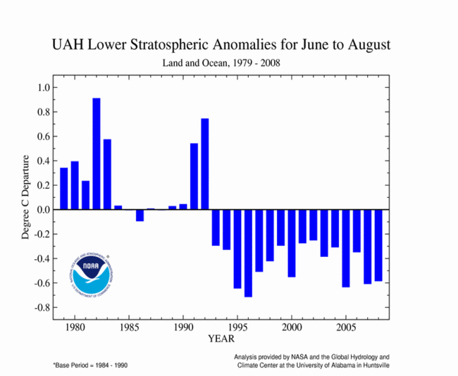
Similar to January-August year-to-date, radiosonde measurements indicate that temperatures were 0.16°C (0.29°F) above average during the boreal summer, giving June-August a rank of warmest in the 51-year record. The table below shows that satellite measurements for the boreal summer were also near to cooler than average, ranking from sixth coolest (twenty-fifth warmest) to eleventh coolest (twentieth warmest) in the 30-year satellite record.
The global mid-Troposphere temperatures were cooler than average during August 2008. As shown in the table below, satellite measurement for August 2008 ranked from seventh coolest (twenty-fourth warmest) to twelfth coolest (nineteenth warmest) on record.
| August | Anomaly | Rank (out of 30 years) |
Warmest (or Next Warmest) Year on Record | Trend |
|---|---|---|---|---|
| UAH mid-trop | -0.15°C/-0.27°F | 24th warmest (7th coolest) |
1998 (+0.45°C/0.81°F) [1992 (-0.27°C/-0.49°F)] |
+0.05°C/decade |
| *RSS mid-trop | -0.08°C/-0.15°F | 21st warmest (10th coolest) |
1998 (+0.50°C/0.91°F) [1992 (-0.25°C/-0.45°F)] |
+0.10°C/decade |
| **UW-UAH mid-trop | -0.02°C/-0.04°F | 19th warmest (12th coolest) |
1998 (+0.61°C/1.10°F) [1992 (-0.41°C/-0.74°F)] |
+0.11°C/decade |
| **UW-*RSS mid-trop | +0.02°C/+0.04°F | 19th warmest (12th coolest) |
1998 (+0.65°C/1.16°F) [1992 (-0.40°C/-0.72°F)] |
+0.16°C/decade |
*Version 03_0
| June- August |
Anomaly | Rank (out of 30 years) |
Warmest (or Next Warmest) Year on Record | Trend |
|---|---|---|---|---|
| UAH mid-trop | -0.14°C/-0.25°F | 25th warmest (6th coolest) |
1998 (+0.48°C/0.86°F) [1989 (-0.23°C/-0.41°F)] |
+0.04°C/decade |
| *RSS mid-trop | -0.06°C/-0.10°F | 22nd warmest (9th coolest) |
1998 (+0.52°C/0.94°F) [1985 (-0.30°C/-0.54°F)] |
+0.10°C/decade |
| **UW-UAH mid-trop | -0.04°C/-0.07°F | 21st warmest (10th coolest) |
1998 (+0.61°C/1.10°F) [1992 (-0.33°C/-0.59°F)] |
+0.10°C/decade |
| **UW-*RSS mid-trop | +0.04°C/+0.07°F | 20th warmest (11th coolest) |
1998 (+0.65°C/1.16°F) [1985 (-0.33°C/-0.59°F)] |
+0.15°C/decade |
| RATPAC | +0.16°C/0.29°F | 19th warmest (out of 51 years) |
1998 (+0.88°C/1.58°F) | +0.15°C/decade |
*Version 03_0
| January- August |
Anomaly | Rank (out of 30 years) |
Warmest [Coolest] (or Next Warmest [Coolest]) Year on Record | Trend |
|---|---|---|---|---|
| UAH mid-trop | -0.16°C/-0.29°F | 27th warmest (4th coolest) |
1998 (+0.55°C/0.99°F) [1989 (-0.25°C/-0.45°F)] |
+0.04°C/decade |
| *RSS mid-trop | -0.09°C/-0.16°F | 23rd warmest (8th coolest) |
1998 (+0.59°C/1.06°F) [1985 (-0.22°C/-0.40°F)] |
+0.09°C/decade |
| **UW-UAH mid-trop | -0.07°C/-0.12°F | 22nd warmest (9th coolest) |
1998 (+0.69°C/1.24°F) [1989 (-0.26°C/-0.47°F)] |
+0.11°C/decade |
| **UW-*RSS mid-trop | -0.01°C/-0.02°F | 21st warmest (10th coolest) |
1998 (+0.71°C/1.28°F) [1989 (-0.23°C/-0.41°F)] |
+0.15°C/decade |
| RATPAC | +0.15°C/0.27°F | 20th warmest (out of 51 years) |
1998 (+0.83°C/1.49°F) | +0.14°C/decade |
*Version 03_0
The table below summarizes stratospheric conditions for August and June-August 2008. On average, the Stratosphere is located approximately between 16-23 km (10-14 miles) above the Earth's surface. Over the last decade, stratospheric temperatures have been below average in part due to the depletion of ozone. The large positive anomaly in 1982 was caused by the volcanic eruption of El Chichon in Mexico, and the sharp jump in temperature in 1991 was a result of the eruption of Mt. Pinatubo in the Philippines. In both cases the temperatures returned to pre-eruption levels within two years.
| August | Anomaly | Rank (out of 30 years) |
Coolest (or Next Coolest) Year on Record |
|---|---|---|---|
| UAH stratosphere | -0.58°C (-1.04°F) | 6th coolest | 1996 (-0.72°C/-1.30°F) |
| *RSS stratosphere | -0.50°C (-0.91°F) | 6th coolest | 1996 (-0.66°C/-1.18°F) |
*Version 03_0
| June- August |
Anomaly | Rank (out of 30 years) |
Coolest (or Next Coolest) Year on Record |
|---|---|---|---|
| UAH stratosphere | -0.58°C (-1.05°F) | 5th coolest | 1996 (-0.71°C/-1.28°F) |
| *RSS stratosphere | -0.50°C (-0.89°F) | 5th coolest | 1996 (-0.64°C/-1.15°F) |
*Version 03_0
For additional details on precipitation and temperatures in August, see the Global Hazards page.
Christy, John R., R.W. Spencer, and W.D. Braswell, 2000: MSU Tropospheric Temperatures: Dataset Construction and Radiosonde Comparisons. J. of Atmos. and Oceanic Technology, 17, 1153-1170.
Free, M., D.J. Seidel, J.K. Angell, J. Lanzante, I. Durre and T.C. Peterson (2005) Radiosonde Atmospheric Temperature Products for Assessing Climate (RATPAC): A new dataset of large-area anomaly time series, J. Geophys. Res., 10.1029/2005JD006169.
Free, M., J.K. Angell, I. Durre, J. Lanzante, T.C. Peterson and D.J. Seidel(2004), Using first differences to reduce inhomogeneity in radiosonde temperature datasets, J. Climate, 21, 4171-4179.
Fu, Q., C.M. Johanson, S.G. Warren, and D.J. Seidel, 2004: Contribution of stratospheric cooling to satellite-inferred tropospheric temperature trends. Nature, 429, 55-58.
Lanzante, J.R., S.A. Klein, and D.J. Seidel (2003a), Temporal homogenization of monthly radiosonde temperature data. Part I: Methodology, J. Climate, 16, 224-240.
Lanzante, J.R., S.A. Klein, and D.J. Seidel (2003b), Temporal homogenization of monthly radiosonde temperature data. Part II: trends, sensitivities, and MSU comparison, J. Climate, 16, 241 262.
Mears, Carl A., M.C. Schabel, F.J. Wentz, 2003: A Reanalysis of the MSU Channel 2 tropospheric Temperature Record. J. Clim, 16, 3650-3664.
Peterson, T.C. and R.S. Vose, 1997: An Overview of the Global Historical Climatology Network Database. Bull. Amer. Meteorol. Soc., 78, 2837-2849.
Quayle, R.G., T.C. Peterson, A.N. Basist, and C. S. Godfrey, 1999: An operational near-real-time global temperature index. Geophys. Res. Lett., 26, 333-335.
Smith, T.M., and R.W. Reynolds (2005), A global merged land air and sea surface temperature reconstruction based on historical observations (1880-1997), J. Clim., 18, 2021-2036.
For all climate questions, other than questions concerning this report, please contact the National Climatic Data Center's Climate Services and Monitoring Division:
Climate Services and Monitoring Division


