|
|
|
 |
| NP-201 |
 |
|
Using remote sensing and modeling for evaluating hydrologic fluxes, landscape states, and constituent transport processes within agricultural landscapes.
National Program 201, Water Quality and Management
Objective 1:
Using remote sensing and modeling for evaluating hydrologic fluxes, landscape states, and constituent transport processes within agricultural landscapes. |

a. Develop mathematical and statistical tools for aggregation and disaggregation of landscape properties, surface states and fluxes using remote sensing and ground truth data from field experiments. |

b. Establish the utility of in situ soil moisture networks in satellite validation, hydrologic modeling and data assimilation. |
Objective 2:
Development of models and remote sensing methods for evaluating environmental impacts of conservation practices at watershed scales. |

a. Determine the dominant spatial and temporal environmental parameters and processes that influence nutrient, agrochemical, sediment, and pathogen fate and transport in surface and subsurface waters at field and watershed scales. |
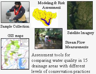
b. Develop and validate new tools and decision support systems within the framework of risk evaluation to evaluate the environmental effects of USDA's major conservation incentives programs and assess effectiveness to mitigate agricultural pollution. |
Objective 3:
Development of remote sensing and data assimilation approaches for improved hydrologic and crop yield modeling and drought monitoring and detection. Refine and evaluate a multi-scale and multi-temporal resolution drought detection and crop condition assessment system using remote sensing and modeling. |

a. Develop a remote sensing-based operational scheme for adjusting land surface model computations due to spatial variability in atmospheric properties caused by dynamic feedback effects with landscape heterogeneity in soil moisture, surface temperature, and vegetation/snow cover. |

b.Develop and evaluate methods for assimilating remote-sensing based soil moisture and ET estimates into hydrologic process models. |
Approach:
A better understanding of the complex hydrologic pathways operating within agricultural landscapes is critical for efforts to minimize the water quality impacts of agricultural production systems, maximize water agricultural use efficiency, and predict the impact of hydrologic extremes on agricultural productivity. Existing shortcomings in process-level hydrologic understanding, modeling tools, and observational resources currently limit our ability to effectively manage many agricultural landscapes. In this project, research will be conducted to develop modeling and decision support tools to quantify and mitigate the impact of agricultural production on water quality. The effectiveness of current major USDA water quality conservation programs, both now and under climate change scenarios, will be evaluated. Our understanding of factors governing the temporal and spatial patterns in soil moisture and surface energy fluxes within agricultural watersheds will be enhanced, and remote-sensing tools for the large-scale measurement of these variables will be improved. Landscape and remote sensing research will be linked through the development of effective spatial scaling tools capable of linking the vastly different spatial supports of ground-based (0.01 to 100 m) and space-borne (> 500 m) observations of land surface variables (e.g. evapotranspiration and soil moisture). In aggregate, these improvements should manifest themselves in an enhanced ability to manage agricultural systems for conservation goals and monitor vital hydrologic variables. In particular, novel remote sensing, modeling, and data assimilation tools will be developed that enhance our ability to detect drought, monitor root-zone soil moisture and forecast crop yields. |
|
|
|
|
|
|
Last Modified: 12/20/2007
|
|