|
|
|
 |
| NP-204 |
 |
|
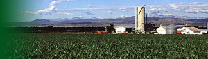
Assessing Climate, Soil and Landscape Processes Affecting Agricultural Ecosystems
National Program 204, Global Change
Objective:
Develop new methods and models to assess the movement and fate of soil carbon and water in agricultural ecosystems at multiple scales. |
Sub-Objective 1
Develop methods to measure and characterize crop residues and soil carbon under different management systems. |

Sub-Objective 2
Assessing carbon sequestration and trace gas emissions under conservation practices at the landscape scales in the Mid-Atlantic region as part of the GRACEnet CLR (cross-location) project. |

Sub-Objective 3
Assessing impacts of soil redistribution on carbon dynamics by use of a biogeochemical model that includes landscape processes and scale measurements. |

Sub-Objective 4
Modeling soil carbon sequestration and carbon fluxes at local, regional scales. |

Sub-Objective 5
Integrate global soil moisture mapping from satellites into the land surface component of atmospheric prediction models. |
< td> |
Approach:
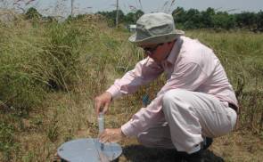
The terrestrial carbon (C) and hydrologic cycles are closely linked and have influence on, and in turn, are influenced by changes in global climate. This project will develop improved methodologies for utilizing sample, flux and remote sensing data in the spatial characterization of key components of land-surface C and water cycles. Quantifying soil and crop residue C by spectoscopic characterization will provide cost-effective methods for monitoring or model validation. In support of the GRACEnet Cross Location Project, trace gas emissions from winter cover crops will be monitored to assess overall global warming potential of prospective best management practices for C sequestration. The C fluxes associated with soil erosion and subsequent C redistribution over a field or landscape is poorly known, so Cesium-137 will be used as a tracer to estimate the magnitude and impact on redistribution patterns at field and watershed scales. Tower flux measurements will be used to validate spatial estimates of CO2 assimilation primarily through the parameter, light use efficiency. Combined crop growth/biogeochemical models use land cover, leaf area index, and soil and residue C for spatial model inputs and light use efficiency for spatial model validation. These models can simulate the impacts of various management practices on the C and hydrologic cycles under current and changed climate. Because CO2 assimilation by vegetation cover is in turn linked to plant availability of soil water, improved technologies and models developed within this project for assessing soil moisture status will enhance global climate models for climate change predictions. |
|
|
|
|
|
|
Last Modified: 12/20/2007
|
|