|
|
- Advisories
- Forecasts
- Observations
- Java Tools »
- Related Information
- Contact Us
|
 |
 |
|
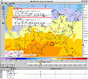
The New Flight Path Tool
This new version of the Flight Path Tool runs as an application instead of an applet.
It supports all of the same features found in the old Flight Path Tool plus:
- a fully resizable map
- map printing and export
- saving configuration between sessions
- semi-transparent data layers
- customizable contour intervals
- preview of available data sets
- fine-grained animation control
- saving cross-section paths
- and more...
Download the new Tutorial (PDF Version)
for a preview of the application, and to provide some
guidance on how to use the tool. This documentation is also
available in HTML format, through the "FYI / Help"
button above.
Although the Flight Path Tool is fairly large to download (approximately 6.8 MB), it remains
cached on your local system for faster startups in the future.
For slow internet connections (28.8 to 56K modems), it will likely take several
minutes to load the first time. We think you'll find the wait worthwhile.
Having any trouble? Check out our Frequently Asked Questions.
More information can also be found in the Product Description Document.
Please ensure you have the latest security patches for your OS and the most recent Java Runtime Environment (look for a button labelled "Java Software Download").
|
|
|

