Skip Navigation Linkswww.weather.gov 
NOAA logo - Click to go to the NOAA homepage National Weather Service Forecast Office   NWS logo - Click to go to the NWS homepage    
Pendleton, Oregon
navigation bar decoration    
 
WFO PendletonWFO PendletonWFO Pendleton

Current Hazards for NE Oregon & SE Washington

Select map to see which areas are affected.
*** IMPORTANT ***
The products listed on this page may have expired.
This list is provided so you may see
when the last hazardous weather message was issued.
Product Last Issued At
Tornado Warning N/A
Severe Thunderstorm Warning N/A
Severe Thunderstorm / Tornado Watch N/A
Severe Weather Statement N/A
Flash Flood Warning N/A
Flood Warning N/A
Flash Flood Statement N/A
Flood / Flash Flood Watch N/A
Flood Statement N/A
Hydrologic Outlook N/A
River Statement N/A
Winter Weather Hazards N/A
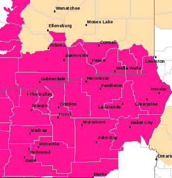
Red Flag Warning / Fire Weather Watch Wed Sep 17 2008, 2257 PDT
Non-Precipitation Hazards N/A
Air Stagnation Advisory N/A
Special Weather Statement Tue Sep 16 2008, 1438 PDT
Short Term Forecast Fri Sep 19 2008, 2257 PDT
Hazardous Weather Outlook Sun Sep 21 2008, 508 PDT
Local Storm Reports N/A
Civil Emergency Message N/A
(Warning...these products may no longer be valid!)

 
 WWUS86 KPDT 180557
 RFWPDT
 
 RED FLAG WARNING
 NATIONAL WEATHER SERVICE PENDLETON OR
 1057 PM PDT WED SEP 17 2008
 
 
 ORZ609>611-630>635-638-WAZ609-631-633-675-681-180700-
 /O.EXP.KPDT.FW.W.0009.000000T0000Z-080918T0600Z/
 EAST SLOPES OF NORTH OREGON CASCADES-
 EAST SLOPES OF CENTRAL OREGON CASCADES-DESCHUTES NATIONAL FOREST-
 CENTRAL MOUNTAINS OF OREGON-COLUMBIA BASIN OF OREGON-
 SOUTHERN BLUE AND STRAWBERRY MOUNTAINS-
 NORTHERN BLUE MOUNTAINS OF OREGON-EAGLE CAP DISTRICT-
 WALLOWA DISTRICT-BAKER VALLEY-
 EAST SLOPES OF THE SOUTHERN WASHINGTON CASCADES-
 LOWER COLUMBIA BASIN OF WASHINGTON-BLUE MOUNTAINS OF WASHINGTON-
 EASTERN WASHINGTON SOUTHERN COLUMBIA BASIN-YAKAMA ALPINE DISTRICT-
 1057 PM PDT WED SEP 17 2008
 
 ...RED FLAG WARNING WILL EXPIRE AT 11 PM PDT THIS EVENING...
 
 THE RED FLAG WARNING WILL EXPIRE AT 11 PM PDT THIS EVENING. 
 
 INCREASING MID LEVEL MOISTURE AND THE WEAKENING OF THE HIGH
 PRESSURE SYSTEM OVER THE PACIFIC NORTHWEST HAS CAUSED THE AIR
 MASS OVER THE REGION TO BECOME LESS UNSTABLE THIS EVENING.
 MEANWHILE SURFACE RELATIVE HUMIDITIES HAVE RISEN DUE TO COOLER
 EVENING TEMPERATURES. AS A RESULT...THE HIGH HAINES OF 6 HAS
 LOWERED AND CRITICAL FIRE WEATHER CONDITIONS HAVE RELAXED.
 MINIMUM SURFACE RELATIVE HUMIDITIES WILL AGAIN BE LOW THURSDAY
 AFTERNOON...BUT THE HAINES VALUES ARE EXPECTED TO REMAIN AT LOW
 TO MODERATE LEVELS. THEREFORE THE RED FLAG WARNINGS ACROSS THE
 REGION HAVE BEEN ALLOWED TO EXPIRE.
 
 $$


Webmaster
US Dept of Commerce
National Oceanic and Atmospheric Administration
National Weather Service
Pendleton Weather Forecast Office
2001 NW 56th Drive
Pendleton, OR 97801

Tel: (541) 276-7832

Disclaimer
Information Quality
Credits
Glossary
Privacy Policy
Freedom of Information Act
About Us
Career Opportunities

National Weather Service Mission: "The National Weather Service (NWS) provides weather, hydrologic, and climate forecasts and warnings for the United States, its territories, adjacent waters and ocean areas, for the protection of life and property and the enhancement of the national economy. NWS data and products form a national information database and infrastructure which can be used by other governmental agencies, the private sector, the public, and the global community."