
 Feeds & Data
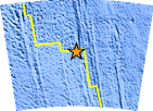
Magnitude 6.9 - WEST OF MACQUARIE ISLAND
2007 January 30 04:54:50 UTC
Earthquake Details
| Magnitude | 6.9 |
|---|---|
| Date-Time |
|
| Location | 54.888°S, 145.733°E |
| Depth | 10 km (6.2 miles) set by location program |
| Region | WEST OF MACQUARIE ISLAND |
| Distances | 840 km (520 miles) W of Macquarie Island, Australia 1905 km (1180 miles) S of MELBOURNE, Victoria, Australia 2190 km (1360 miles) S of CANBERRA, A.C.T., Australia |
| Location Uncertainty | horizontal +/- 12.9 km (8.0 miles); depth fixed by location program |
| Parameters | NST=142, Nph=142, Dmin=>999 km, Rmss=1.38 sec, Gp= 47°, M-type=moment magnitude (Mw), Version=8 |
| Source |
|
| Event ID | us2007yeai |
- This event has been reviewed by a seismologist.
- Did you feel it? Report shaking and damage at your location. You can also view a map displaying accumulated data from your report and others.
Earthquake Summary

The following is a revised REPEAT revised release by the United States Geological Survey, National Earthquake Information Center: A strong earthquake occurred 855 km (530 miles) W of Macquarie Island, Australia. 1905 km (1180 miles) S of MELBOURNE, Victoria, Australia at 10:54 PM MDT, Jan 29, 2007 (Jan 30 at 2:54 PM local time in Epicentral Area). The magnitude and location may be revised when additional data and further analysis results are available. This earthquake is located in a remote area and no damage or casualties are expected.
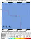
Earthquake Maps


Scientific & Technical Information

- Preliminary Earthquake Report
- U.S. Geological Survey, National Earthquake Information Center:
World Data Center for Seismology, Denver
