
 Feeds & Data
Magnitude 6.8 - SOUTHERN SUMATRA, INDONESIA
2007 October 24 21:02:52 UTC
Earthquake Details
| Magnitude | 6.8 |
|---|---|
| Date-Time |
|
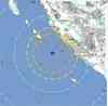
| Location | 3.838°S, 100.909°E |
| Depth | 30 km (18.6 miles) set by location program |
| Region | SOUTHERN SUMATRA, INDONESIA |
| Distances | 140 km (85 miles) W of Bengkulu, Sumatra, Indonesia 335 km (205 miles) SSE of Padang, Sumatra, Indonesia 385 km (240 miles) SW of Jambi, Sumatra, Indonesia 680 km (425 miles) WNW of JAKARTA, Java, Indonesia |
| Location Uncertainty | horizontal +/- 13.2 km (8.2 miles); depth fixed by location program |
| Parameters | NST=163, Nph=163, Dmin=>999 km, Rmss=1.43 sec, Gp= 50°, M-type=moment magnitude (Mw), Version=8 |
| Source |
|
| Event ID | us2007iwca |
- This event has been reviewed by a seismologist.
- Did you feel it? Report shaking and damage at your location. You can also view a map displaying accumulated data from your report and others.
Earthquake Summary


The following is a release by the United States Geological Survey, National Earthquake Information Center: An earthquake occurred about 135 km (85 miles) W of Bengkulu or about 675 km (420 miles) WNW of JAKARTA at 3:02 PM MDT, Oct 24, 2007 (Oct 25 at 4:02 AM local time in Indonesia). The magnitude and location may be revised when additional data and further analysis results are available.
Felt Reports
Felt (IV) at Argamakmur, Lais, Muaraaman and Mukomuko; (III) at Kapahiang. Also felt at Bengkulu, Jakarta and in Singapore.
Tectonic Summary
The magnitude 6.8 southern Sumatra earthquake of October 24, 2007 indicates subduction related thrusting on the boundary between the Australian and Sunda plates. At the location of this earthquake, the Australian Plate moves northeast with respect to the Sunda plate at a velocity of approximately 60mm/yr. The October 24th event occurred within the rupture area of the magnitude 8.4 earthquake of September 12, 2007, which had similar fault slip. Since the September 12th earthquake, this section of the subduction zone has remained very active, producing more than 8 events greater than magnitude 6.0.
Earthquake Information for Asia
Earthquake Information for Indonesia
 Tsunami Information
- NOAA West Coast & Alaska Tsunami Warning Center
- NOAA Pacific Tsunami Warning Center
- Tsunami Information Links
The earthquake locations and magnitudes cited in these NOAA tsunami bulletins are very preliminary and may be superceded by USGS locations and magnitudes computed using more extensive data sets.
Earthquake Maps


Scientific & Technical Information

- Preliminary Earthquake Report
- U.S. Geological Survey, National Earthquake Information Center:
World Data Center for Seismology, Denver
